ORH_wxman
-
Posts
93,092 -
Joined
-
Last visited
Content Type
Profiles
Blogs
Forums
American Weather
Media Demo
Store
Gallery
Everything posted by ORH_wxman
-
I’m sure there will be OP GFS and Euro runs in the next week days that pop fantasy storms. It’s funny though how much hand-wringing there is over not seeing them consistently yet. GFS has shown some modest snow events out in clown range but the angst over no KU type storms showing up reveals just how much the operational runs are dopamine for some of the forum. Show me something inside 6 days, and then we’ll talk.
-
10 days a little short for snow threats if we're talking Euro OP....you're only out to like Dec 9 on the 10th day. I think msot threats would be beyond that date....save maybe if Dec 6-7 trends colder for NNE which is an outside possibility.
-
The PAC at the end of that run gives me hope that even if NAO starts to break down later in December, we won't go into a torchy pattern. That was a pretty weenie run of the EPS.
-
When it comes to ensembles, I usually look for a few things to be more confident: 1. Consistency.....are the runs more or less showing the same thing for several cycles in a row? 2. Timeline gets closer....is the pattern on the ensembles getting closer or staying out in clown range? Typically you want to see the pattern starting to get established inside of 10 days 3. Cross-guidance ensemble support. Are the EPS and GEFS agreeing with each other or are they showing different patterns? When you have multiple ensembles suites showing the same pattern, that increases confidence.
-
They will be quite a bit more accurate than operational runs though out in that time range.
-
I would also note that deterministic model guidance tends to perform quite poorly in high-magnitude blocking regimes...particularly during La Nina when storm threats are northern-stream dominant. But even just general longwave pattern verification tends to be worse in extreme blocking situations as per the literature on NWP guidance. I gave a presentation on this at the 2011 AMEX conference as it pertained specifically to east coast storms. The models were having a really hard time "seeing" storms more than a few days out. It was a decade ago, but same logic would apply. Models are better now, but their relative skill declines in these high latitude blocking setups. During that 2010-2011 winter. almost all the big storms we got hit by weren't well-modeled more than about 3-4 days out. The best one was probably the 1/12/11 event which was pretty consistent on guidance form 5-6 days out. But I recall plenty of storms that season where they were on model guidance 7-8 days out and then disappeared by 4-5 days out never to return, and then vice-versa....nothing at all and then they would show start showing up 4 days out. Boxing day was kind of a weird one in that it disappeared 3 days out only to return 24 hours out.
-
12z GFS could happen....I'd bet against it, but it's just one possibility out of many. Probably 70-80% of the possibilities will be pretty good for us. But there will be a small minority where things go belly-up like on the 12z GFS where it retros the NAO block almost into the arctic ocean and prolongs the SE ridging....but again, that is a weird deterministic solution 10+ days out so you'd bet against it.
-
Starting to get some weird cutoff scenarios on the OP GFS runs out in clown range. That is not uncommon with the type of block in place. You just hope you cash in on one of them.
-
Yeah. Late Feb/Mar 2010. That was the most recycled rotted airmass I can remember.
-
Didnt you poo-poo Feb 2013 and then two years later proclaimed that we would only get nickel and dimes?
-
Blocks this powerful typically last at least a couple weeks but the pattern beyond that is dependent on a lot of other things. In 2010-2011, the block hung around for over a month before breaking down during the 1/12/11 snowstorm. But the fun continued another few weeks because the Pacific became favorable and the Atlantic was still ok even after the massive block broke down.
-
Weeklies look good until near Xmas when they go to crap and stay that way into January. Take it fwiw....they've been pretty awful though this season...esp beyond week 2/3. They missed the upcoming pattern even just last week and they missed the mid-November flip.
-
That is interesting. The rare tropical volcano that contributes to warming rather than cooling. That’s the way to do it though…inject a bunch of water vapor and little to no sulfur.
-
I don't even think the GEPS would be that bad...they are definitely a warmer look but they still have a big NAO block so we'd have chances. Obviously we'd prefer the GEFS/EPS to verify, but I wouldn't be bridge-jumping either if the GEPS was closer to reality. GEPS almost reminds me of late Dec 2002/early Jan 2003 pattern which was very good for the interior.
-
No doubt a lot of similarities between the modeled pattern and Dec 2010 (and early Jan 2011).
-
Yes. There's probably multiple reasons for it....first, we're just entering winter so everyone is impatient. Second, I'll bet a large part of it is there are no snowstorms on the operational runs. That gets a lot weenies anxious, even though it shouldn't. Snowstorms occur from shortwaves.....good luck having models find a shortwave in the flow 10+ days out. Third....there is definitely Tip's psychology aspect to it. Some probably doom and gloom so they can either be "right" or "happy"....if they are wrong, it's cold and snowy and they won't care that they were wrong. But if they're right, they get to troll everyone and pat themselves on the back for calling the bust well in advance.
-
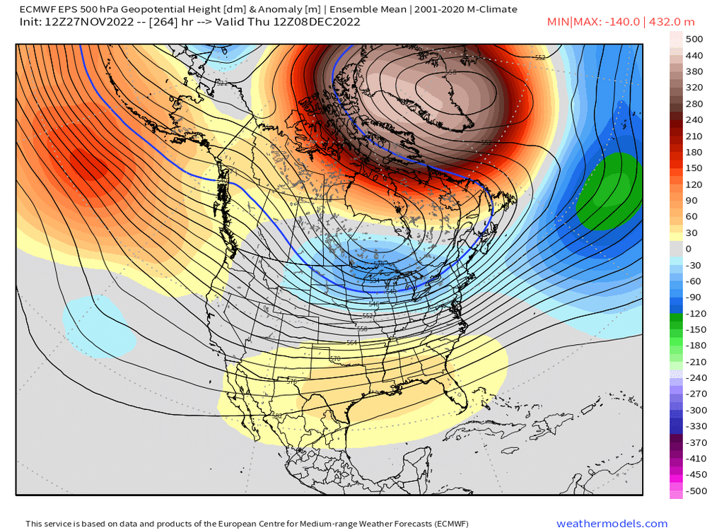
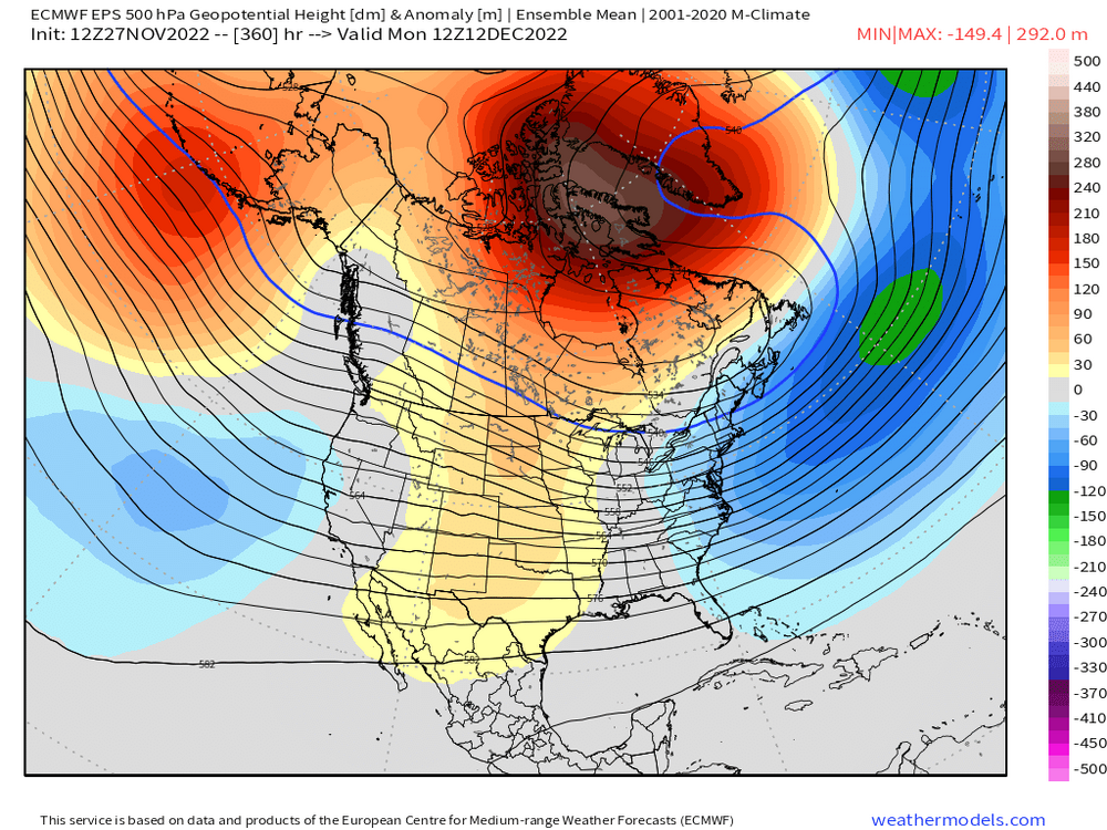
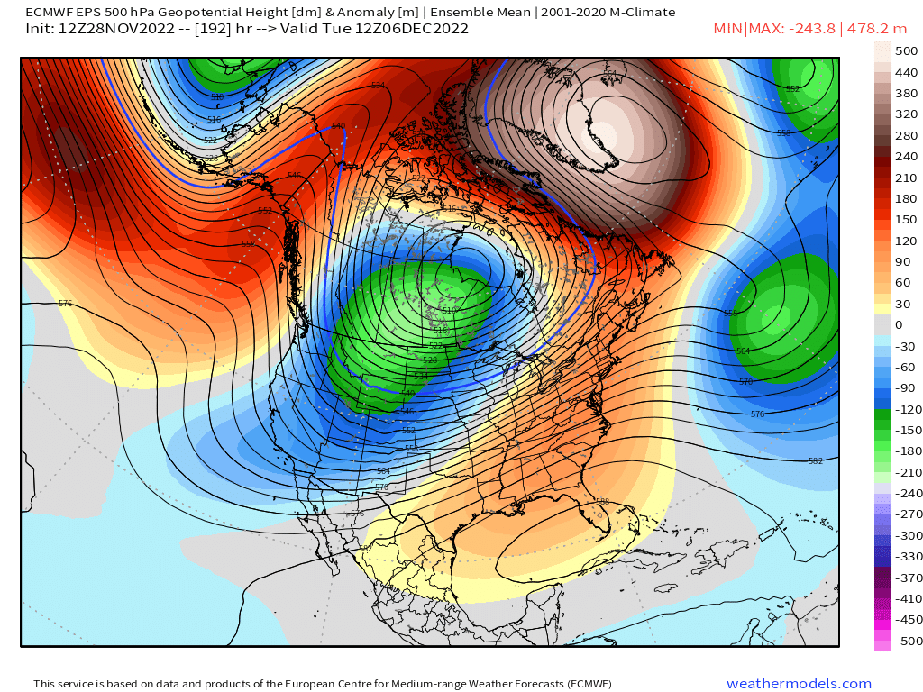
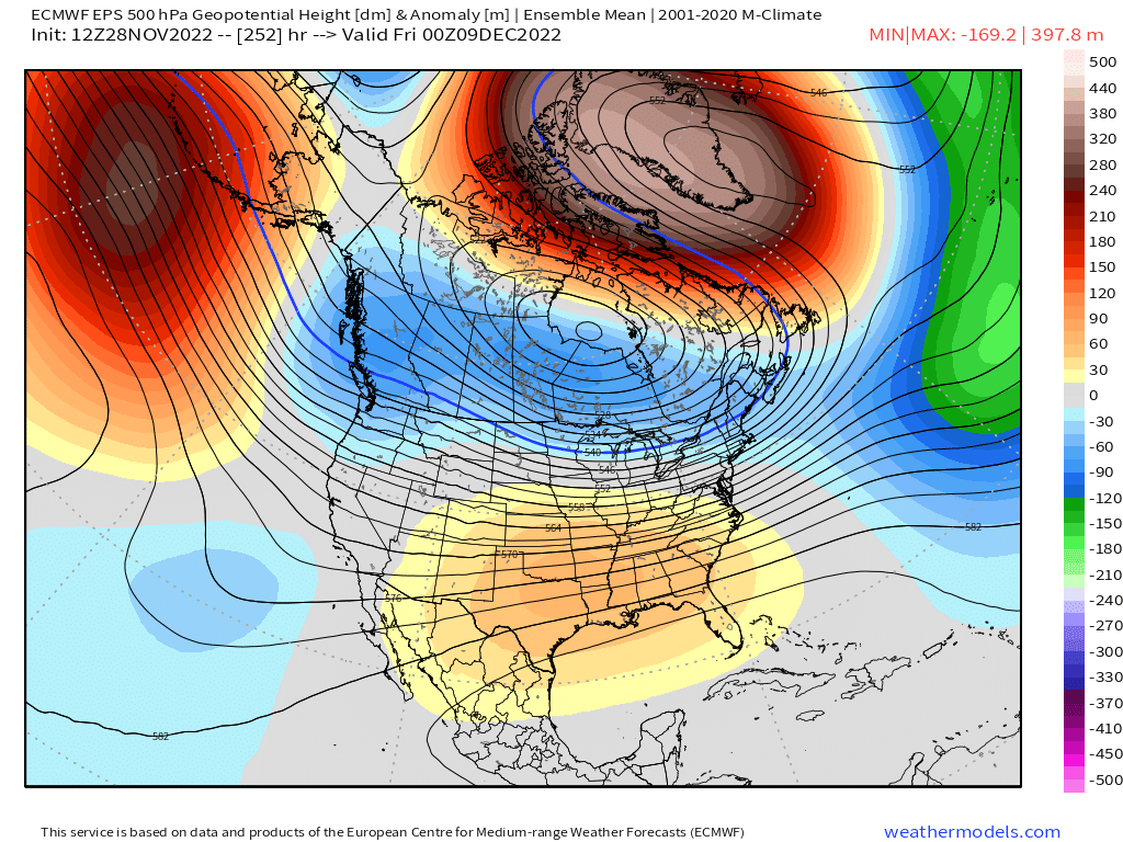
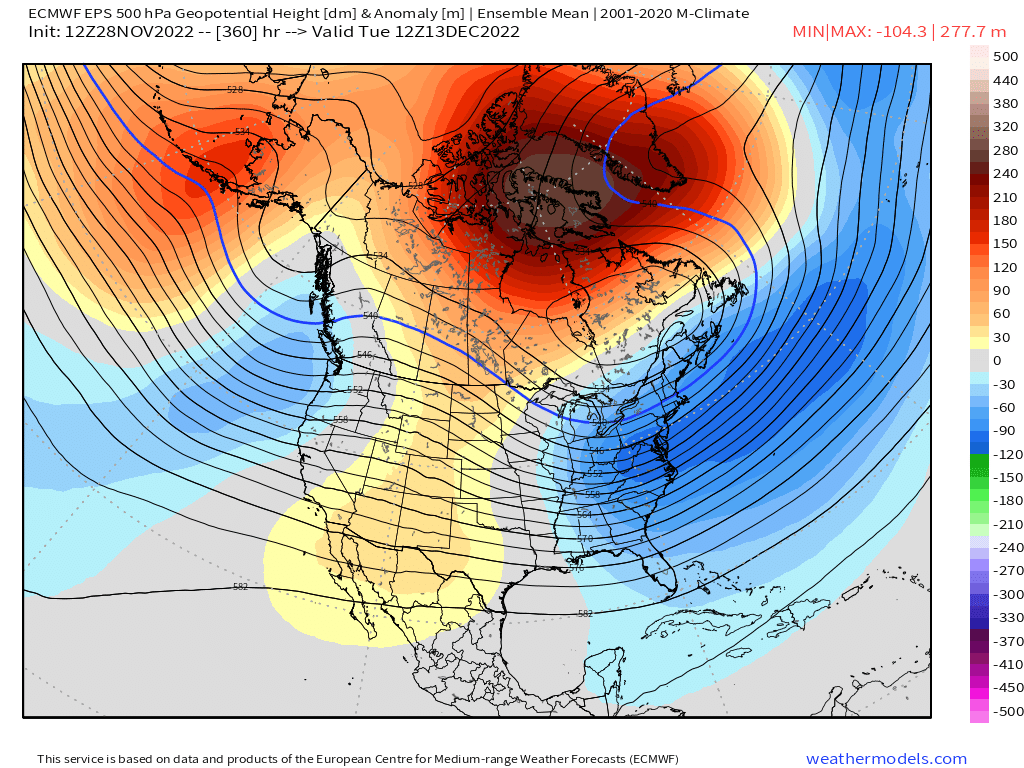
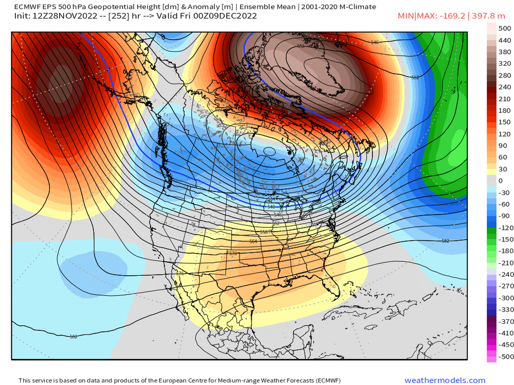
Here is the progression in 3 charts....first one is Dec 6, 2nd is Dec 9, and last one is Dec 13


-
The pattern change is going to go through multiple stages....when the block is first forming, we get the torch with a likely cutter or warmer type system going to our northwest (Dec 5-7) which actually feeds back into the block.....2nd, we get the initial cold push which still has higher heights in the south. This is what Tip was commenting on earlier with "Velocity" issue. This would be like in the Dec 8-12 time frame. We can get a system in this type of flow, but usually clippers and SWFEs. Then finally, you get the higher heights in the south retrograding into the western plains and Rockies (post 12/12....heading toward mid-month) which is what Scooter was talking about above....that's more of a big dog look. That's a very good pattern for larger snow events for us. Hopefully it sets up and hopefully we cash in.
-
Not in Dec '69. Feb '69 maybe. Dec '69 was huge in far western New England....but it was merely just very good over interior spots like from ORH to CON.
-
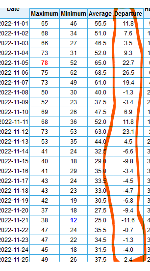
Only in the Vatican is 12 days of AOB average temps after record warmth the first 10 days of the month is considered no pattern change.

-
I haven't kept up in recent months, but back in the first weeks after the eruption, I recall reading that it didn't eject enough mass sulfates up into the stratosphere to really be anything close to something like a Pinatubo when it comes to climate impacts. I'm guessing that is still the case....a lot of the material probably stayed under water and/or settled back to the earth as much of it never got high enough to get into the stratosphere.
-
KCON
-
No pattern change to see here
-
Here's a good visual....you can see early on how there are still above normal heights in the south while we are BN..... Then you will note how late in the period at the end, the heights are below normal across all of the east including the southeast with the ridging pushed back toward western plains and rockies.