ORH_wxman
-
Posts
93,095 -
Joined
-
Last visited
Content Type
Profiles
Blogs
Forums
American Weather
Media Demo
Store
Gallery
Everything posted by ORH_wxman
-
Yeah I bet we’ll have a few runs between now and end of next week that show some ridiculous solutions out in clown range. Fwiw, not exactly same evolution but the “blocky fujiwara” type development happened in the already-mentioned Dec ‘81 storm http://www.meteo.psu.edu/fxg1/NARR/1981/us1206.php#picture
-
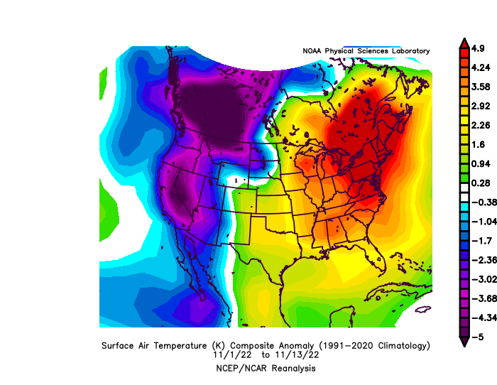
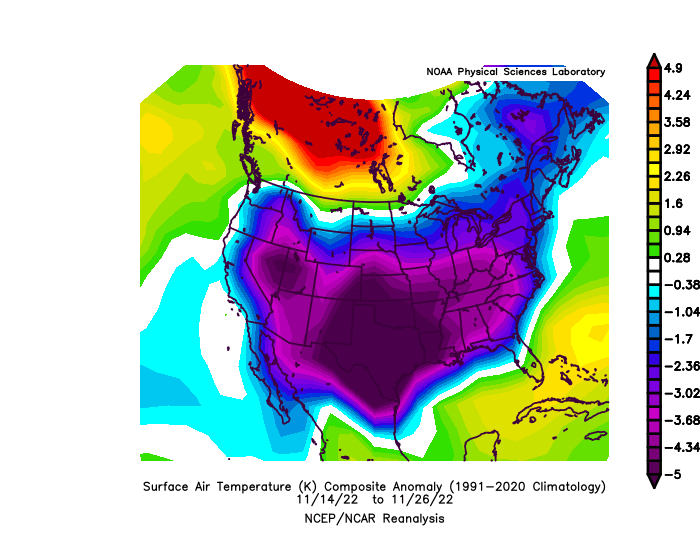
It’s not just that +20 didn’t continue, we reversed the departures and were below normal for the better part of 2 weeks. I’m not sure how Bretton Woods not being buried by the end of November is relevant to the discussion outside of ski enthusiasts who were planning a trip for 11/28-30 when we warmed back up. There were already plenty of ski resorts opening during that pattern shift posted in the ski thread so they took advantage for sure. Let’s not play the anecdotal game where any of us can write a narrative. Sticking to empirical metrics, the pattern was very different on a large scale than the beginning of the month. The numbers are what they are.
-
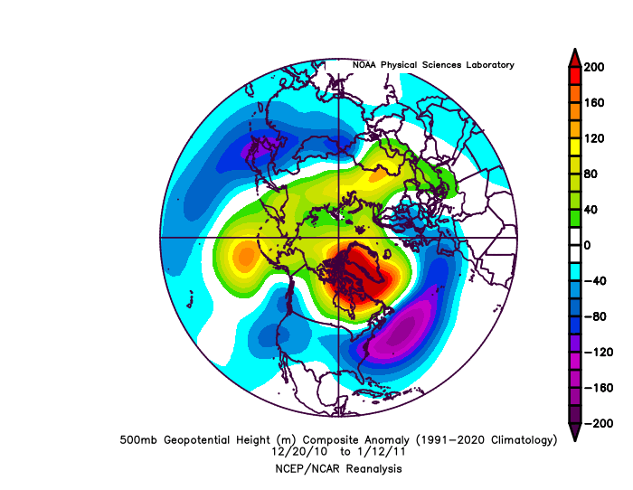
NAO blocks can reload too after a period of decay. That definitely happened in 2010-2011…even after the monster block (with a couple reloads) finally broke down after the 1/12/11 storms, we got some mini-reloads…a more east-based block formed ahead of the 1/27/11 system.
-
By definition a block is decaying as soon s it reaches peak strength. But the decay stage can last a long time...even weeks sometimes. Sometimes you get little reloads too.
-
Yeah and I wonder if we get multiple shots at this....that first window is still kind of early in the pattern. Historically, the better shot would be when the block is kind of decaying which would be more like beyond 12/15. But we've seen multiple storms before in a big NAO block regime. Feb 2021 is one example....March 2018 is another.
-
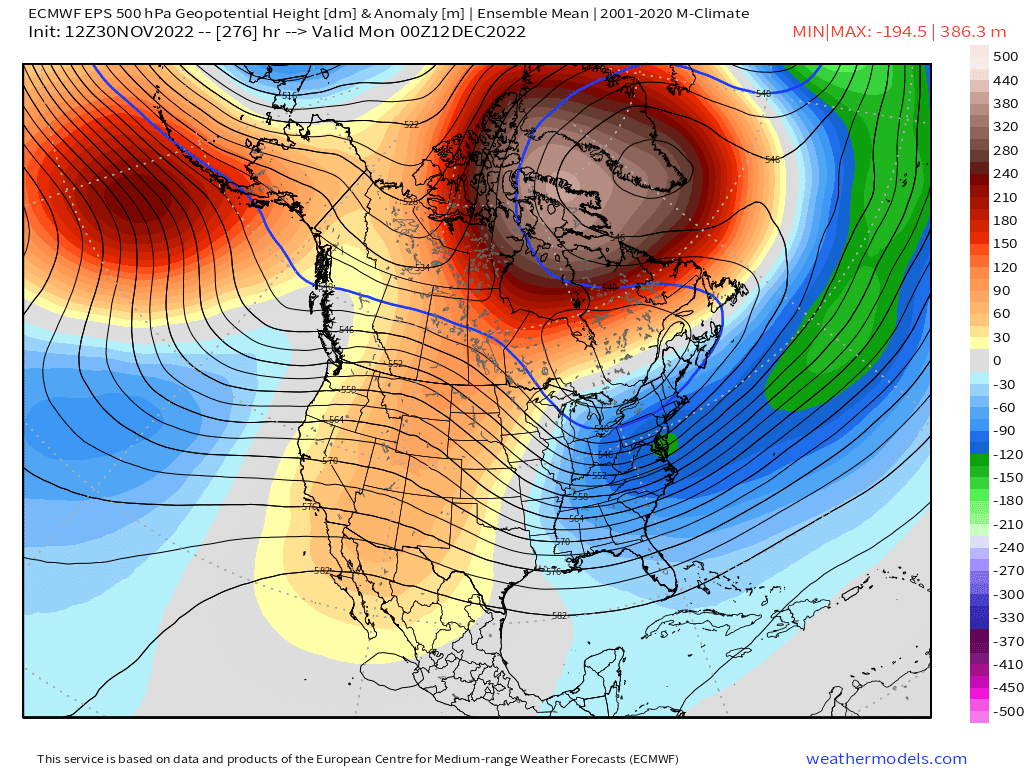
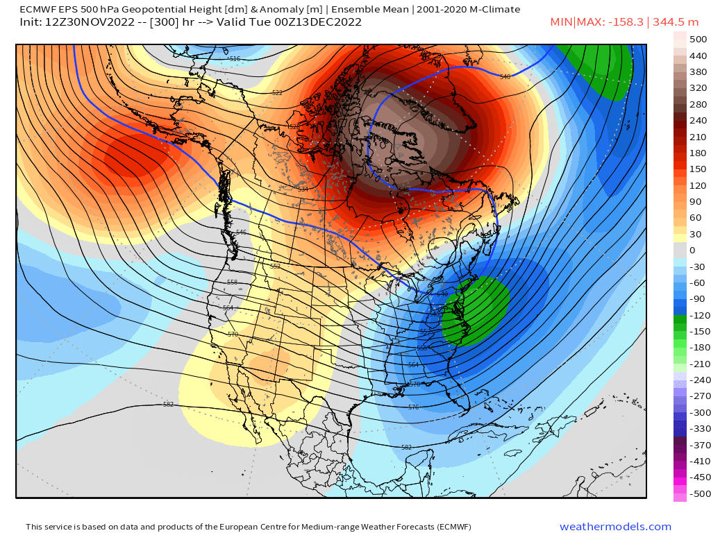
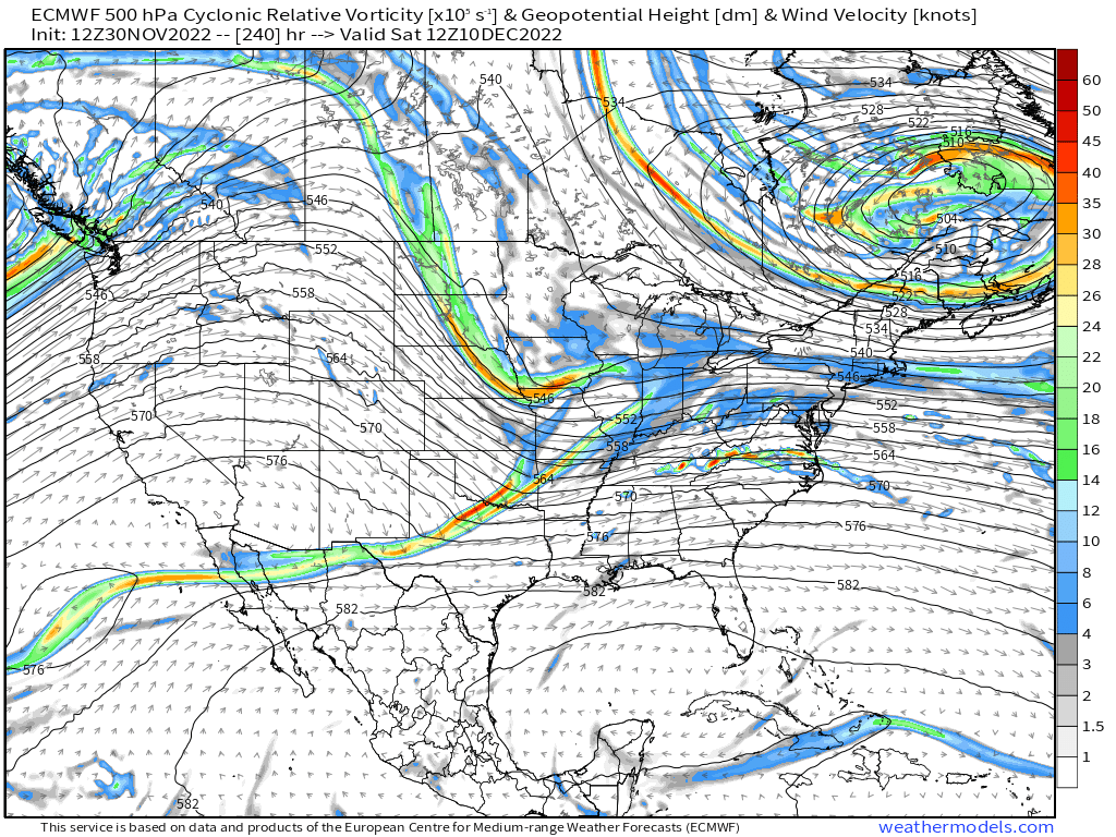
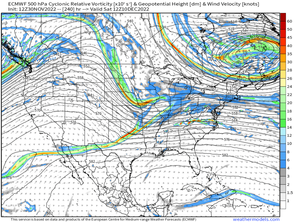
That look around Dec 12-13 is starting to get really good....not just general pattern-wise...but that's very threatening for a big system when you get the Rockies ridge popping coinciding with the Atlantic look there


-
Dec 1960 was one of the all time early season KU doozies, but it wasn’t the same pattern as we have coming up. Didn’t have an NAO block. It did have a temporary 50/50 low though which is what the NAO blocks usually help out with (keeping the 50/50 low in place)…and huge western ridge that went all the way up the Arctic Ocean.
-
Yeah and these dates could move all over the place given that the models won't "see" some of these shortwaves....either that or they manifest/eject from their original location in a different manner than the models thought at further lead time. I mean, just as en example, the OP Euro in clown range at D10 is ready to try and pop an OH valley---> NJ coastal type model.....which is prob one of the few types of coastals that could be supported in the still-high gradient pattern there which I don't have to tell you (582dm heights hanging out over N FL fighting the slowly retreating PV lobe to our north)
-
Dec '81 is actually not a terrible analog either for this pattern. I think late Dec '10- early Jan '11 is a better one, but Dec '81 had that block dominating the pattern for weeks. Parts of Dec 1995 are a good match too.
-
Euro is still mostly rain for Dec 6 system....but there is a bit of ice/snow for NNE this run. That's pretty close though to being something more wintry for a lot of the region....would need another 100-200 miles press on that PV lobe in hudson bay which is certainly doable at D5-6. However, the follow up wave is more intriguing to me....would still be a fast mover, as the gradient hasn't relaxed yet, but that one looks like it could produce something wintry if gradient doesn't grind it up. That would be in the Dec 8-9 range.
-
I wasn't talking about you btw....your view of whether this upcoming pattern is favorable or not is not tied to D10-15 OP GFS runs. The satire of the SE NH/S ME/Essex county MA screwzone was a different topic....
-
You can see why some people jump off the tobin when the OP models don't show snowstorms....all you have to do is look at the inverse reactions when there's a huge storm at 300 hours.
-
GEFS are trying to get that Dec 11 period in a favorable look for a larger type storm....a few days ahead of previous runs and particularly the EPS. GEFS pop that Rockies ridge which is very bullish signal for a coastal given the block already in place
-
Looks like ORH over to my hood is just far enough south.
-
It's probably one reason (even if minor) that causes models to sometimes underestimate cold in a favorable pattern....on the front side of that, we may lay down snow pack in upstream areas and the models then struggle with how to handle that...and then of course, if the model guidance is wrong on where the snow pack increases, it will be wrong on its lower level boundary layer gradient in that area so all the future frames are corrupted too.
-
Lavarock just saw this run

-
Yes, Dec 6-7 would be an overrunning/SWFE type winter system if it trends cold. The potential for coastal storms would be later into the pattern....most likely beyond 12/12.
-
To steal a term from Tip....when you have that type of arctic configuration, the "Correction vector" is colder for us more often than not.
-
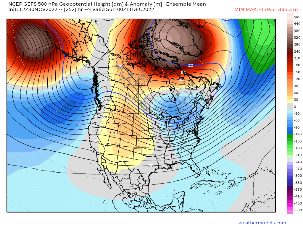
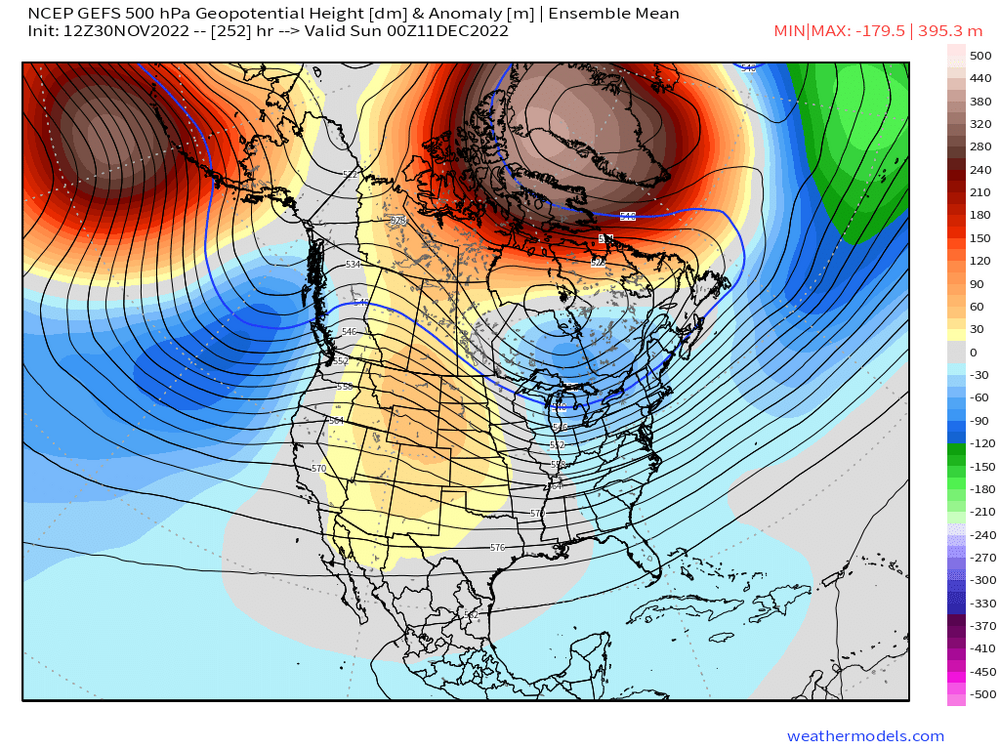
The extremely amplified EPO ridge is often something that causes systems to trend colder inside of 7 days....we have been talking a lot about the developing monster NAO block, but in the early stages of that, we actually have a very stout EPO ridge dumping cold into Canada....see below.....this is what is starting to cause the flow to become flatter over the east....pressing the cold further south ahead of the Dec 6-7 system

-
Gotta hedge for being unlucky sometimes....we remember the good patterns that smoked us, but sometimes we have good patterns that don't produce...there's been some big disappointments in good patterns before (see Dec 1987, Jan 1985, Feb 2010 in SNE, Jan/Feb 1980) Man, the '80s sucked considering we had some good patterns, lol
-
2020-2021 def left some on the table. This year though, we do have significantly better blocking than that year had at least in December....we'll see how later in the winter goes. We also had a poor Pacific for the first 3 weeks of January 2021....even a neutral N PAC would've probably produced more snow events for us those first 3 weeks. Instead, we basically condensed winter in a 3 week period from end of January through mid-February....sans the 1 wintry week we had in December before the cutter from Dante's Inferno. Seems like you are going for a better N PAC in January than Jan 2021 had.
-
N PAC was also pretty damned ugly in Jan 2021 until later that month...once it shifted to a better look, we really went to town for about 3 weeks. The block also kept retrograding and became a Davis Strait block by the end of the month. We did have a bunch of close calls though earlier that January which easily could have been decent storms. That block essentially kept us from blowtorching all month....we didn't have any fresh cold, so it was still above normal, but if you recall, I think we struggled to get warmer than 40-45F in any of those days....most being in the 30s with lows in the 20s...minimums were a lot more AN than the maximums were.
-
Hard not to compare these two...people shouldn't expect the same results, but there's obviously potential
-
Full blown El Nino North Pacific look. I'm a bit skeptical it looks that nice, but the EPS were showing a more favorable PAC near the end of the run.