ORH_wxman
-
Posts
93,095 -
Joined
-
Last visited
Content Type
Profiles
Blogs
Forums
American Weather
Media Demo
Store
Gallery
Everything posted by ORH_wxman
-
We fight the western troughing until around 12/12….which is what helps keep the SE ridging stout. The Dec 7-8 system though gets pinned under the block and provides enough confluence to give us a shot for Dec 9-10 if it can amplify enough. One good trend in the past 24h is pretty good agreement that the PAC gets a lot more favorable beyond 12/12. Our best period might be 12/15-12/25 with the combo of decaying NAO block and a vastly improved N PAC.
-
Dec 9-10 I think is our best shot until post-12/12 when the southern ridge starts retrograding.
-
Happy birthday old man winter. Keep them coming.
-
I remember when we had a massive cutter on 12/12/10 in the middle of that monster block and the meltdowns were just epic. Stuff like “the cutter should be impossible because there’s a -NAO”. Lol.
-
The first thing I always looked at when forecasting for the monadnocks and ORH hills in Decembers was to pull up the SST anomaly map
-
The most hilarious part of the reasoning going with the anomaly map is that the lowest anomalies were over New England from interior New Hampshire to interior MA….. You can tell instantly that person has had almost no experience forecasting in New England.
-
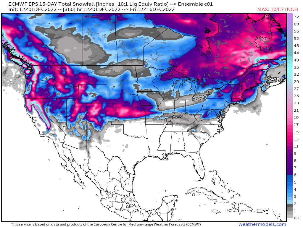
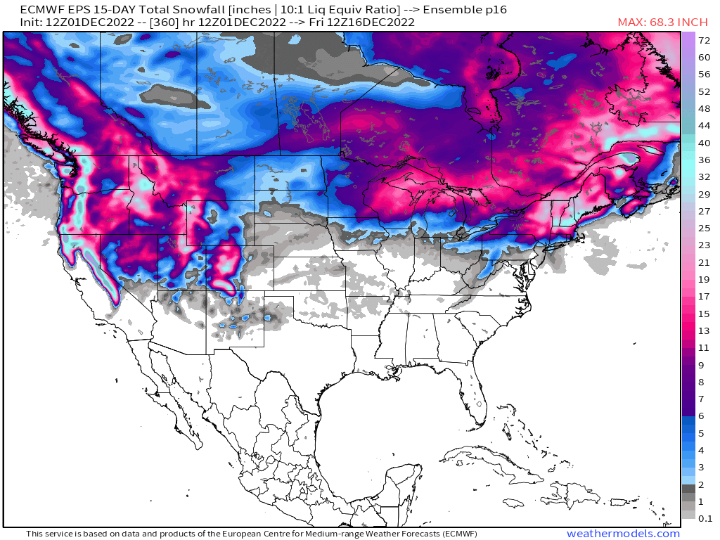
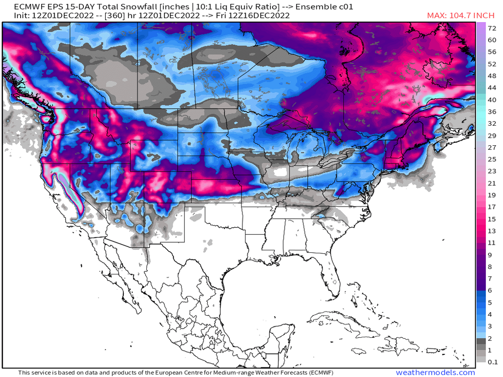
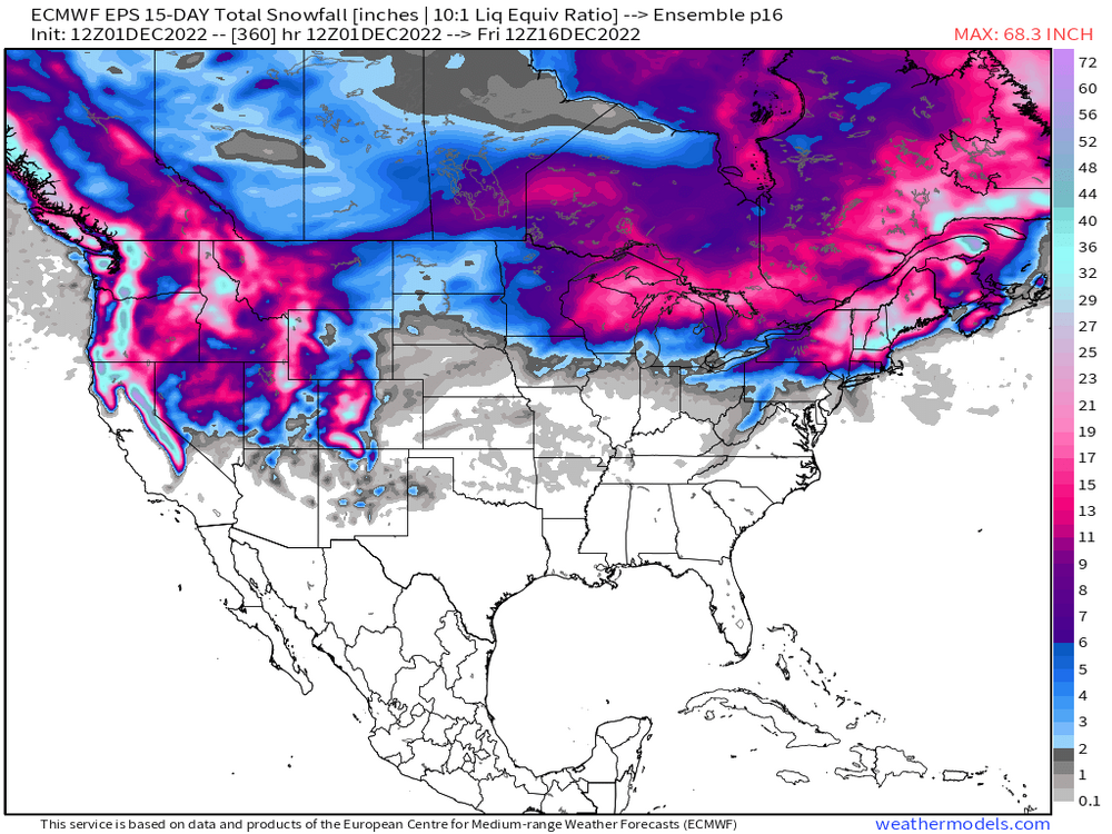
The Pacific is definitely the biggest difference between the GFS suite and the ECMWF suite. GFS has been screwing around with the troughs out west more aggressively than the Euro.
-
18z gfs digs a western trough in Mexico….shades of Dec 2021
-
Pattern change set in during early Dec 2010....here's what it looked like for 16 days Dec 5-20, 2010.....BOS, ORH, and PVD all had zero measurable snow during this 16 day stretch. BDL had 0.3" from a squall I think. This isn't trying to scare anyone, but it reiterates that great patterns can sometimes not produce, or take a while to produce. WE know it eventually went gangbusters, but it didn't happen right away. OTher years like 1995 it happens almost right away.

-
I still think we need to watch the follow up wave (Dec 9…maybe as early as Dec 8 or late as Dec 10) for something. It wouldn’t be huge but it could be one of those fast movers if things align.
-
People want clown maps that show good snow. That’s really what the anxiety is all about. Deep down many won’t admit that it’s the OP runs not showing blizzards is what is concerning to them….it’s not the ensemble mean they are concerned about. You’d think it wouldn’t be that way since most posters here have been on these forums for years (if not decades).
-
The control run was more for me and Tip
-
Ray ran P16 member from his basement
-
The Pacific look keeps changing in that Dec 8-13 time range. Most of the storm threats are going to be from the pacific as shortwave eject out and underneath the block....and there's the added complexity of the central/southeastern ridge in the process of retrograding westward which also mucks up the ability for guidance to show a lot of continuity in handling shortwave traversing the flow. So basically we get: Atlantic ---> Stable on guidance Pacific ---> Volatile on guidance CONUS ---> Semi-volatile on guidance Not a good recipe for getting consistent storm threats showing up on model guidance.
-
PAC almost looking slightly El-Ninoish at the end. Subtle drop in heights SW of Aleutians and pumping of heights over AK and PNA ridge region.
-
This is prob not far from the truth. Not uncommon at all for models to be all over the place until much closer on individual storm threats. Esp in a high blocking pattern.
-
Retro storm in clown range on Euro today. You’re gonna see plenty of weird solutions that appear and disappear from cycle to cycle with this pattern.
-
He really needs to move out west with some elevation....that's where the seasons match the solar insolation the most. We're significantly more lagged here.
-
Yeah it's definitely about 300-400 miles south of yesterday's 12z run. Not sure it means much though....EPS didn't trend with the block between 12z and 00z...so I'd want to see other guidance do it too.
-
GGEM was a close miss for Dec 9th....prob gonna be a lot of large run to run swings on these threats more than a week out.
-
Yeah it was intriguing that it was trending colder, but now that the trend sort of stopped....it's pretty meh. It was always tougher for us too vs NNE.
-
Dec 1961 had an epic one on Xmas eve that ended predawn hours Xmas morning. Much of the interior from ORH-eastward had 18-20+, but even the coast did well until you got to the south coast and Cape.
-
PNA spike is what you’ll want to look for when trying to get a big dog storm. We typically don’t have big dogs without a PNA ridge spike. It’s possible (like 1/12/11) but not common. Events will typically be more of the fast movers and quick redevelopers when it’s -PNA/-NAO
-
The following Decembers had at least one day where the AO reached -4 SD (dataset goes to 1950) 2009 1976 2010 2000 1968 1963 1950 1995 1978 1962 1966
-
It can go well too…..Feb 22-28, 1969