

ORH_wxman
-
Posts
93,095 -
Joined
-
Last visited
Content Type
Profiles
Blogs
Forums
American Weather
Media Demo
Store
Gallery
Everything posted by ORH_wxman
-
‘64-65 was a weak La Niña.
-
All 3 of those were El Niño’s too (2 of them super ninos) where climo is a lot more favorable in the 2nd half of winter. Harder to rally in a La Niña but maybe we do this year.
-
This has been more like 2015-16…esp recently with the shitty El Niño pattern. It does look like we go more favorable El Niño pattern for later in the month but not before another 10-12 days of horse shit.
-
We’ll see how poleward that ridge gets out west. If it doesn’t get sufficiently poleward, then that period is likely to be a dud…at least in terms of major snow potential. We’ll prob get something in New England just because out of sheer chance and latitude, but I’ll be watching the ridge amplitude…esp since there doesn’t seem to be any Atlantic blocking during that period, though that could always change.
-
TWC music from '93-94 winter. Basically its code for "the pattern looks like a cold gradient pattern" where we are on the cold side. Week 3 looks more classic big ridge out west but week 4 starts going toward more typical La Nina look but it's cold at least...not a torch February look. Everything retros a bit in week 5/6 but still seasonable around here so it would be a decent pattern....though we're getitng into utter clown range at that point.
-
Should've waited for the weeklies to post this @CoastalWx
-
If only we had an arctic airmass on the cold side of the boundary.
-
The final week of January into early February probably has to be our Waterloo moment if it's going to happen. Anything after that would likely be too late. If we can rack up 2 or 3 decent storms in that period, then winter is at least salvageable to a certain extent. Can't fully make up for losing half the winter....well, unless we maybe go 2015 or 1956, lol.
-
It's a pretty nice pattern being depicted....there will be some of us forced to jump back on the bandwagon by the weekend if it keeps showing that.
-
Too warm.
-
Looks like a chunk of that is rain, so it prob only gives a few inches at the very end.
-
I think the new england fraud five is backlash, anafront, windex, severe wx, and IVT edit: lol, the creator beat me to it
-
Attribution studies are inherently very difficult. We've seen periods of larger storms before too surrounded by periods of lackluster storms but the recent uptick is unique in its magnitude. It's probably some combo of being luckier recently and CC....just hard to weight each one. Is it 80% CC and 20% luck? 50/50? 30/70? It would take an awful lot of data to analyze it....looking at almost every type of larger storm and analyzing the PWATs, analyzing the H5 flow, etc.
-
I'm getting Bruce Schwoegler backlash PTSD just reading this.
-
Seems like we'll want that whole trough orientation to be shifted a bit east for getting much snow out of it where we are....maybe far western areas don't need too much movement. It would be fitting this winter to get a legit wave bombing on the front, only for the front to be stalled too far west and we get another round of heavy rain while it snows in NY State.
-
A large majority of the recent warming is man-made. Some of the warming earlier in the period (like say, late 1800s through 1940s or so) was largely natural. We came out of a very cold period (aka “The Little Ice Age”) that had established itself in the 1700-1900 time period (even going back to about 1300, but the pronounced cold was more centered in the 1700-1900 time period). I don’t think it does the science or advocacy for reducing fossil fuels much good to hyperbolize and exaggerate claims or focus headlines on tail-end of distribution risks…they are important and should be noted, but we don’t want to start reducing credibility by claiming the RCP 8.5 scenarios as remotely likely. That’s how you undermine the entire issue of CC. But this last paragraph is really out of scope even on the wx side…it’s getting more into a political discussion on the best strategy for public awareness and communicating the science.
-
That even gets part of SNE too. Wonder if we can get that to form a little faster and track over the Cape or something. But that would require a trend actually going right this winter....
-
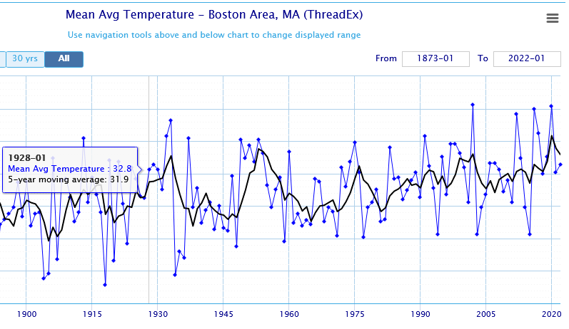
I think this is a good graph for people to see....this is Boston temperatures for winter....you can see both CC and mother nature on this graph....you can see we've warmed over the past 100+ years but even using the 5 year running average (black line), you can clearly see how it's not a smooth line up....there's torch periods and cold periods.....the torch periods have gotten warmer and you can see how the cold periods have also gotten warmer....they don't get as cold as they used to. Some of the pre-1937 stuff is going to be not apples to apples since Logan airport only took obs starting in 1937....prior to that it was not right on the water so you had much colder minimums.
-
They are definitely understaffed and underfunded, but they had him if they had only double checked the trade tickets with DTC to see if they actually were being processed. They never bothered to. It wouldn't have taken much effort at all. But Madoff was a well-respected member of the Wall St community....he ran a successful market-making business and was chairman of NASDAQ for 3 years. It was easy to trust him as long as the documents looked real enough.
-
1913 is a really heavy lift around here, but it's possible if the end of month pattern change is kind of meh.
-
Next 10-12 days are definitely a furnace.... We slowly wait and see if the ensembles keep the post-1/20 pattern change around. So far they have and haven't pushed it back yet, but that doesn't mean much until maybe another 3-4 days pass and we're comfortably inside of 10 days.
-
CC may not directly cause a bad pattern, but it will make a bad pattern warmer than it was decades ago (i.e. "enhance" a warm pattern so to speak)....so you'll get some of those days where it spikes 65F in January and 70F in February when it was almost impossible to do that back in the day. Certainly more frequent now anyway. Anyways, no use in beating the dead horse here. We're not going to turn into a DCA climate in winter....that's not credible. But we're not going to have consistently cold winters like the '60s/70s either. We can still get obscene cold as 2015 taught us (or late Dec 2017/early Jan 2018), but the frequency is less.
-
We're in a rough stretch, but they happen. CC makes them worse than otherwise, but people need to also not fall into being climate weenies too and start assuming these winters will become normal...that's not really any better than assuming they are not affected by CC at all. They are both extraordinary claims that require evidence. Most people would probably be surprised that the entire winter warming trend for us since 1990 is due to post-2015 winters. No surprise when you'd seen the hemispheric pattern since 2015.
-
One thing CC will help with is when we get the right pattern again, we'll prob get buried with like a 150-200" winter in your 'hood (maybe not quite as extreme down here). You'll be pimping the 47" auger housing andf everyone will be jealous.


