

ORH_wxman
-
Posts
93,095 -
Joined
-
Last visited
Content Type
Profiles
Blogs
Forums
American Weather
Media Demo
Store
Gallery
Everything posted by ORH_wxman
-
I would too...it looks more favorable in the Jan 21-25 period than the GEFS, though GEFS look like they are about to go nuclear on the cold near the end. But EPS looks like it might want to build the EPO ridge much higher if it went out further....you could see it building at the very end. Regardless, either pattern is going to give chances better than the current pattern. Hopefully we can get some good timing for once.
-
You won't finish with 3"...the question is whether you limp your way to something like 15" or rally to a more respectable number. I think we need to get on the scoreboard with a decent event prior to the end of the month if we're going to rally to a more respectable number. Hell, I average over 60" and I'm sitting around 3" as well. It's been pretty amazing to avoid even smaller events or front enders. Though we may pick up an inch or so tomorrow morning before it's washed away.
-
EPS is definitely more of a +PNA with a neutral EPO versus the GEFS which is more solid -EPO and neutral PNA. Both patterns are way better than what we currently have but offer different threat profiles.
-
N Conway is on the line there....verbatim it looks like they get a decent shot of snow, but it's close.
-
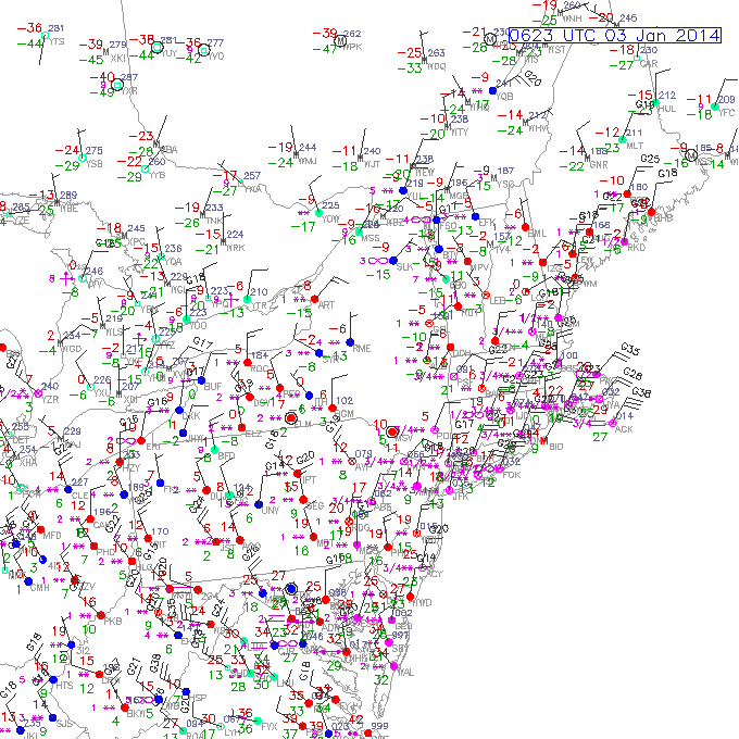
That storm with temps near 0 was actually Jan 2014.
-
Funny you mentioned that year...that map is on there but it's not the first one....it's the last one. The first one is actually a complete rat....Feb 1989. It had cold, but no snow and the largest precipitation event of the month was a 57F cutter that dumped 1-2 inches of rain.
-
Yeah it's hard to get over 30 inches. I've done it maybe half a dozen times in ORH....first time was Jan 1996 after the 1/12 storm that rained on the coast. We had 10-11" of DENSE snow in that which just boosted the piles to unimaginable levels since it had no compacting ability. The depth on the level at that point was around 40-42 inches. Then again in March 2001....that was actually the highest I ever saw in ORH....level depth was somewhere in the neighborhood of 45-46"....I did measure 50" in spots but I don't think that was truly level. It was hard to tell at that point though because the pack had been on the landscape since about 12/20. That pack was different than some of the other ones because it probably held about twice as much liquid equivalent as other packs that exceeded 35". There's a reason that there was still full deep pack (even in sunny areas) across much of the northern half of ORH county a solid week into April 2001 despite no storms for over a week. Then we did it amazingly frequently in the 2011-2015 years.....first in early Feb 2011 when we peaked at 38-39" (i remember being distinctly annoyed we didn't break 40), then again in March 2013 peaking around 35", then again the next year in Feb 2014 peaking around 33" and then of course the 2015 bonanza peaking at 43". We did come close here in Holliston in March 2018 but we were just shy of 30" depth after the 2nd storm.
-
They are sort of taking on a different tenor than the past few days....they kind of screw around with a transition in the Jan 20-25 time range and then hint at something more extreme near the end of the run....which is dumping the PV down into Hudson Bay which would signal something far colder in the CONUS than previous advertised. It is differing from the EPS suite on this....though the EPS looks more faovrable for coastal storms than the GEFS does even if it's not advertising the arctic air intrusion the GEFS is.
-
"Snow shards" should be in the snow weenie glossary. All of us weirdos know exactly what they are.....when the sun (specifically later in the winter when sun angle is higher) starts eating away at the snow banks and piles, they form razor-esque shards sticking out that we all recognize.
-
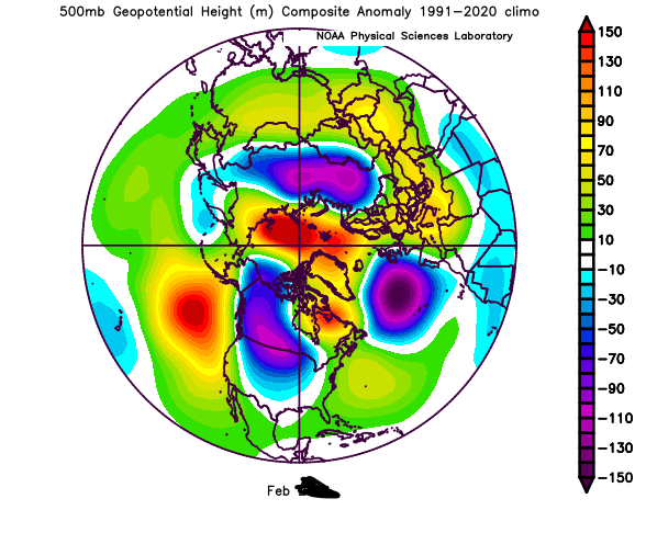
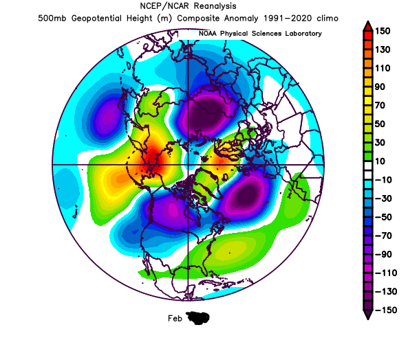
2nd map I posted with the trough axis centered over MN/WI and the SE ridge just offshore was February 2014. I had over 40 inches that month with zero cutters and a -4 temp departure.
-
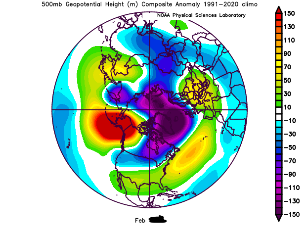
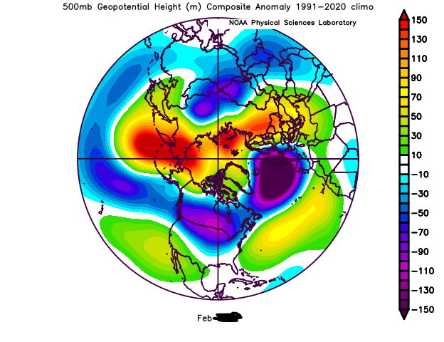
A fun exercise would be to post a bunch of months of H5 composites with the dates on each month blacked out and have people guess if the month was a big snow producer or not. My guess is a lot of people would get them wrong. Everyone is obsessed with looking for the "perfect pattern"....trying to find this unattainable fantasy pattern where cutters are not possible and every threat hits New England with accumulating snow. Example below: Guess which year each of these February maps were? And were any of them prolific?
-
Why all the hand-wringing about a marginal day 8 system on a single OP run? Jesus, some of you have lost it.
-
There's a thread for that system already
-
WaWa has always had exceptional snow making....I remember how well they kept their trails open back in the early 1990s during some of those torchy horrific winters. I took it for granted at the time, but looking back, it was impressive how well they kept coverage on the mountain.
-
Euro was pretty nice up north too. Ski trip saved?
-
Right…the ol’ saying about persistence is you are right until the stakes are highest and then you’re very wrong.
-
Cranmore is a decent family skiing area so I’m betting their snowmaking is pretty solid. Esp being in a really cold area but not quite as snowy as some of the surrounding terrain.
-
I ain’t biting on the new pattern anyway until we’re closer. It’s primarily PAC-driven so Bruce Willis caution flags are out.
-
Kind of reminds me of some of those events in early Jan 2005 when we had that hostile torch pattern but we snuck a couple decent snow events in anyway (one of them produced a narrow zone of big icing in CT)….those top end winters all seemed to feature something like that where you steal an event or two in an otherwise hostile pattern. The shit seasons are mostly the opposite…you never score in a bad pattern and you whiff more than you should in a good one.
-
Yes it’s been nothing but high heights up there since Xmas.
-
Even in 2015 we had great timing on 2 events…2/2/15 was a would-be cutter where the primary made it to CLE and then hit a brick wall of confluence…so it redeveloped we we got 12-20”….then, less than a week later, we had the Feb 7-9 overrunning event that was like 60F in Philly and DC…we avoided a warm rainer in that one due to some well-timed confluence up north yet again. The south coast actually had some issues in each storm so you can see how it wasn’t that far away from being more tainted for the rest of SNE. It was a great pattern that turned epic because we got “lucky” on small scale nuances in 2 events. When we’re looking at ensembles, we cannot tell how those nuances will play out. We only see the very larger picture on the longwave pattern. I think if you’re nitpicking the ensemble pattern shown, maybe you want to see some lower height anomalies in the 50/50 region. But you only need them there when a storm is trying to cut…otherwise it doesn’t really matter
-
There’s no such thing as a pattern that doesn’t risk cutters. Maybe something like Feb 2010….lol…but that’s about it. I’ll take that ensemble look anyway though. Poleward ridge in the eastern EPO domain will give us chances. There’s no guarantees in wx.
-
Quite a bit colder looking on GEFS than previous runs. More like EPS now.
-
Canadian too.
-
Snoozefest…hopefully something looks interesting after the 20th by the weekend or early next week.


