

ORH_wxman
-
Posts
93,092 -
Joined
-
Last visited
Content Type
Profiles
Blogs
Forums
American Weather
Media Demo
Store
Gallery
Everything posted by ORH_wxman
-
Wednesday Feb 18 Mixed event. NOPE …ain’t happenin’
ORH_wxman replied to HoarfrostHubb's topic in New England
Whatever happens on Wednesday, looks like advisory snow or better is in a pretty narrow band…something like 50-75 miles tops. -
Wednesday Feb 18 Mixed event. NOPE …ain’t happenin’
ORH_wxman replied to HoarfrostHubb's topic in New England
Yep wrong thread but NAM looked like a loaded gun at 84h there. -
Yep. Stein over the last week-plus sucks. Especially once you get deeper into February. The sublimation/melting around the edges is pretty minimal when you are cold/dry in mid-January. But once you are in mid-February, even in a cold pattern, it really gets noticeable with those shards forming on snow banks and edges. Need to refresh that stuff.
-
At least there’s a lot of action to track. Very very active pattern coming up. Could be a lot of disappointment too when you’re playing with fire along the boundary but there’s always a few patterns where you need to ride the line if you want the goods.
-
I like the 61/31 with 9.5” of snow. Looks like a coop from elevated Utah or Arizona.
-
On the flip side, that’s a great spot to be right now. Having each storm teasing you. If it was doing this inside of 3 days that would suck but decent chance you get something good.
-
The system that improved the most today on both EPS and Euro Skynet was Friday night/early Saturday. Doesn’t get shredded as much but also pretty cold too. Monday still has the most upside imho, but Friday night could end up pretty good too if we trend it like today. Monday definitely got some more support too today. But being 8 days out makes it less meaningful when you see a model shift.
-
Let’s split the difference.
-
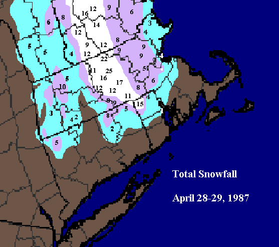
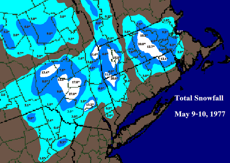
Given it was also my very early days of making maps, I put north foster coop too far north. It can extend a bit further south with the 12”+ on both maps.
-
I did maps for April ‘87 and May ‘77 almost 20 years ago. They are of course, primitive MS paint jobs but they still give a decent idea. Only annoying thing is for some reason I did not use to nearest tenth in the April ‘87 map.
-
Even almost a quarter give ORH 20”+. Definitely the most aggressive in a while. Lot of ways for it to screw up but the benefit of having like 3-4 different waves is you also have a decent chance of one or two of them working out.
-
EPS is sneaky decent for Saturday too. Pretty snowy for SNE and CNE on that one.
-
Saturday and Monday are in pretty good spots for 6 and 8 days out respectively.
-
Compromise works great!
-
OP run is warmer for Wednesday. More of a CNE deal.
-
Yeah euro skynet is pretty cold for both smaller waves (Wed and Fri)…the Wed event is pretty suppressed on that model. Doesn’t get precip north of pike.
-
The site also looks like it’s missing Nov 10-12, 1987 for the early season notable storms. Oct 10, 1979 is another good one.
-
Yeah it’s basically a temporary spike producing a good Rockies ridge…not a classic full scale PNA ridge but eastern Rockies ridges have often produced excellent systems. That allows the shortwave to dig more and produce a coastal. We just don’t know quite yet where it makes the turn north. GFS was wide right.
-
Euro skynet is a huge hit for Monday. Let’s hope it has a clue. It’s actually ok for the Friday system too. CT peeps get a bit on Wednesday.
-
The AI guidance has seemed to like the Monday threat more than the others. Though I thought the 06z OP Euro looked pretty threatening at 144h.
-
GGEM is focusing most of the stuff on the Saturday/Sunday shortwave…decent little event but again, those prob have limited upside potential of high end advisory or maybe low end warning.
-
GFS trying for next Monday but this run will be wide right. That’s the one to watch. There’s advisory potential on the earlier events but upside is limited. The Monday system would have more upside.
-
The funny part is the real pics in many cases are more impressive than AI for that stretch. A lot of the pics from 2015 in Boston look not credible.
-
Torch tiger has been like metfan this winter except usually it’s metfan posting bombs at 300+ hours that never verify. This season it’s been Torch posting 300+ hour warm spells that never verify.
-
Next Sunday/Monday is the system I’m watching. Anything before that is stein/shredded and obvioisly could be ptype issues too…but again, even the all snow areas on those doesn’t look prolific. Maybe advisory snowfall for whoever is lucky enough. Sunday/Monday could miss too but it has more room to amplify into a real system than the others.


