ChesterfieldVa80
-
Posts
118 -
Joined
-
Last visited
Content Type
Profiles
Blogs
Forums
American Weather
Media Demo
Store
Gallery
Everything posted by ChesterfieldVa80
-
Thanks. Im trying to decide if I want to go up near the blue ridge parkway in Southwestern Nelson County for this. Elevation 2700. I dont want to go up there for less than half foot.
-
Do you have maps of the rgm?
-
What are the thoughts on the sleet shown on the NAM for the Richmond area? With upper air cooperative wouldn't this be a rain or snow situation?
-
Jan 31st - 33rd Storm Obs and Disco like it's 1979
ChesterfieldVa80 replied to Bob Chill's topic in Mid Atlantic
3" here in Western Chesterfield/midlothian VA area -
Richmond Metro/Hampton Roads Discussion
ChesterfieldVa80 replied to RIC Airport's topic in Mid Atlantic
Going to be tough to get more than 3-4" in the metro with this setup. -
Jan 31 - Feb 1 Event - STORM MODE THREAD
ChesterfieldVa80 replied to stormtracker's topic in Mid Atlantic
Why are the ensembles so much snowier down here in the Richmond area? Is this skewed by an outlier or too? -
Jan 31 - Feb 1 Event - STORM MODE THREAD
ChesterfieldVa80 replied to stormtracker's topic in Mid Atlantic
Can you share this image for entire state of Va? -
I'm surprised by the all of the snow/freezing rain wording in the point/click NWS forecast out of Sterling. Im specifically referring to Sunday and talking the northern Shenandoah valley. They even have it in the forecast for Highland County....
-
It seems to me one of the best places to be for this one is out towards SW VA. All guidance seems to give that are a no nonsense thump of 7-12" followed by some light fluff
-
Do you think the Richmond area is still squarely in the game? I appreciate all your detailed analysis!
-
One thing I like about this mean for the Richmond area is that it's basically the exact same as the operational. Leaves room for improvement down this way.
-
January Storm Term Threat Discussions (Day 3 - Day 7)
ChesterfieldVa80 replied to WxUSAF's topic in Mid Atlantic
Where was the low positioned in comparison to its previous run? -
I cant believe it does l I title to nothing in VA east of 77.
-
32 here 25 miles southwest of Richmond. Not expecting much of anything.
-
Nasty dry slot across South central Virginia there. Ouch
-
I'm sure he will trim back the northern extent in VA. That map was based upon information from 18 and 00z yesterday/last night
-
Where do you access the RGEM?
-
Canadian is well south of its previous runs as well.
-
This was 21z for reference. Things are going the wrong way.
-
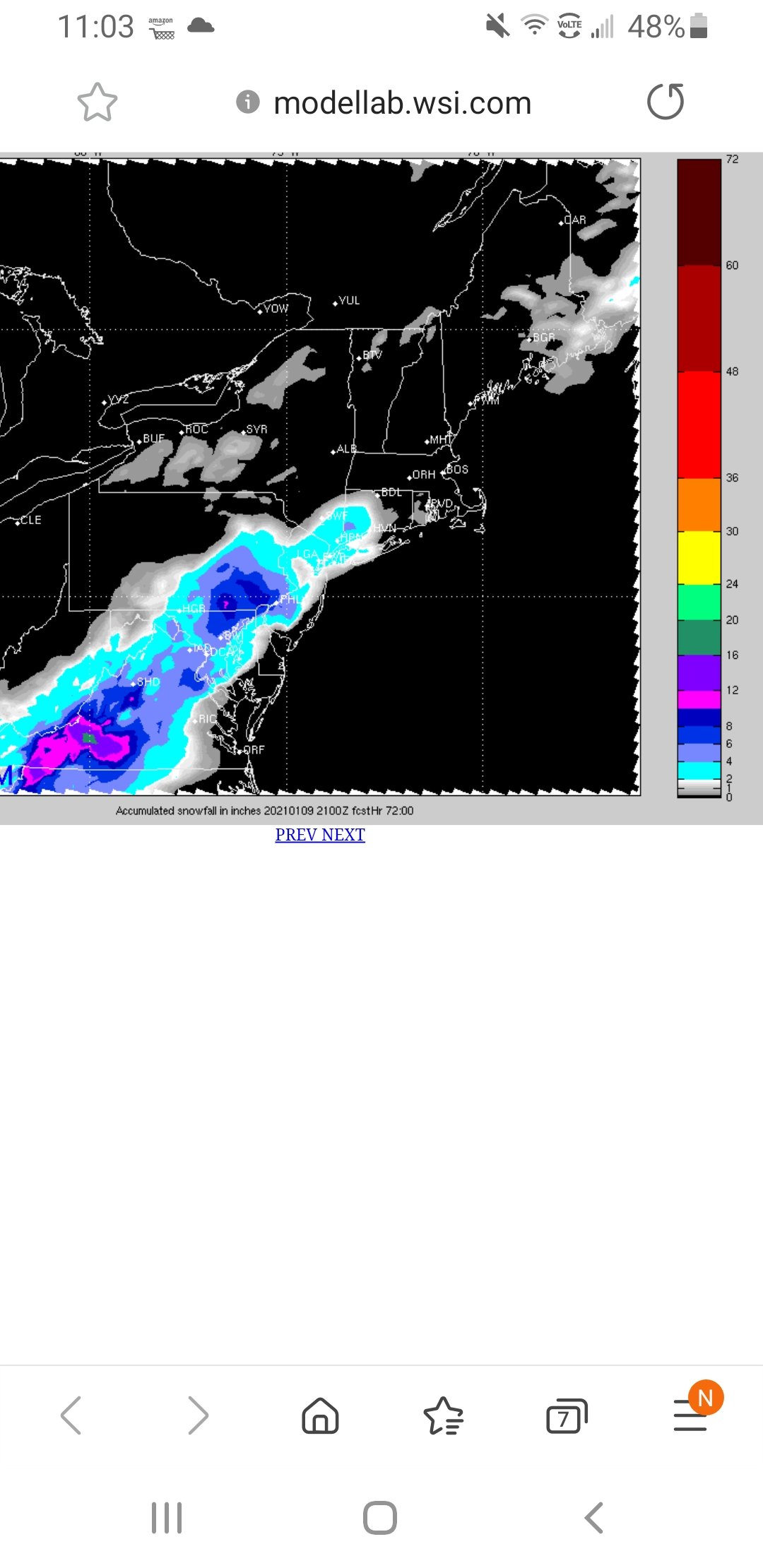
I have it through WSI. It may look north of other guidance..... But its been trending south the last several runs. At 15z it had accumulating snow into Winchester and near Baltimore if that helps..
-
This seems to be trending to a Southwest NC mountain special.
-
This is really surprising considering the nam was a whiff for VA. I wonder if there is a member or two skewing the mean.
-
What about south central VA? 25 zmiles southwest of Richmond
-
Do you think this is trending in the direction that may get areas 20 mikes SW of Richmond involved?
-
Does it extend to Southside richmond?