

baltosquid
-
Posts
507 -
Joined
-
Last visited
Content Type
Profiles
Blogs
Forums
American Weather
Media Demo
Store
Gallery
Posts posted by baltosquid
-
-
2 hours ago, MN Transplant said:
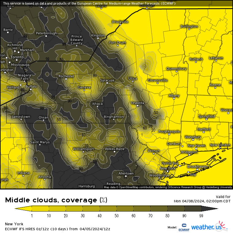
Ok, here's the 12z Euro for NY. Yellow is good, dark is bad.
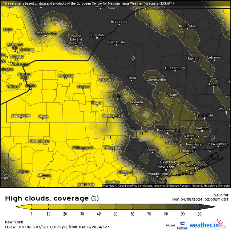
First up, no low clouds as we've been talking about. Splotchy mid-level clouds, and then an exiting deck of high-level clouds.
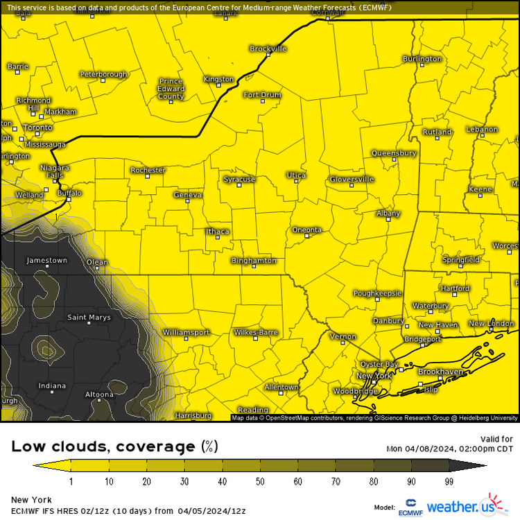

King Euro, go and get your crown and make this happen… seems like the best I can realistically hope for if fully clear is off the table.
-
 1
1
-
-
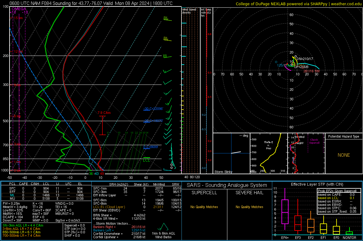
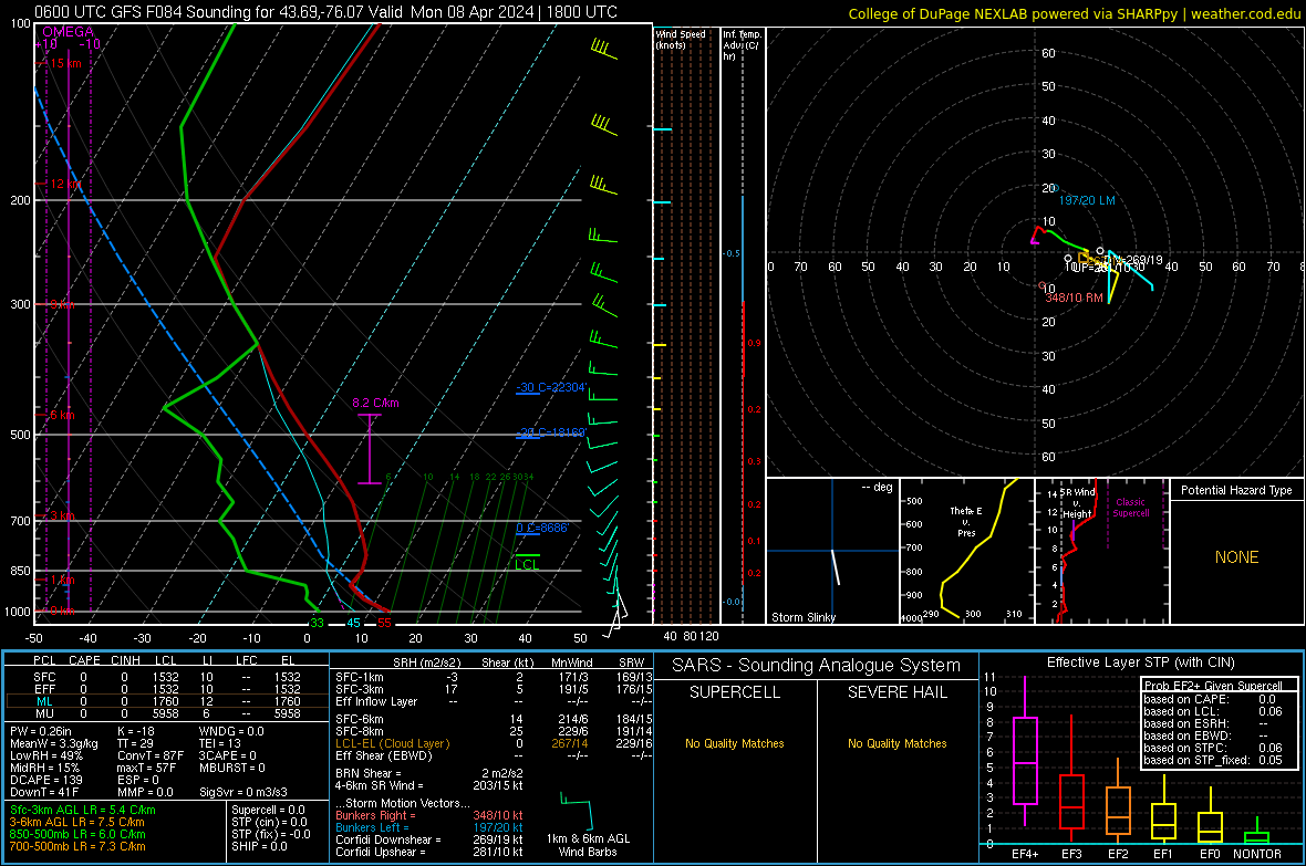
3 hours ago, MN Transplant said:
And we got one! Here's the big difference between the NAM and GFS. You can see the saturated layer from 250 to 350mb on the GFS sounding, which is our upper-level clouds. On the NAM, not so much.
(edit - for the Watertown/Syracuse area)
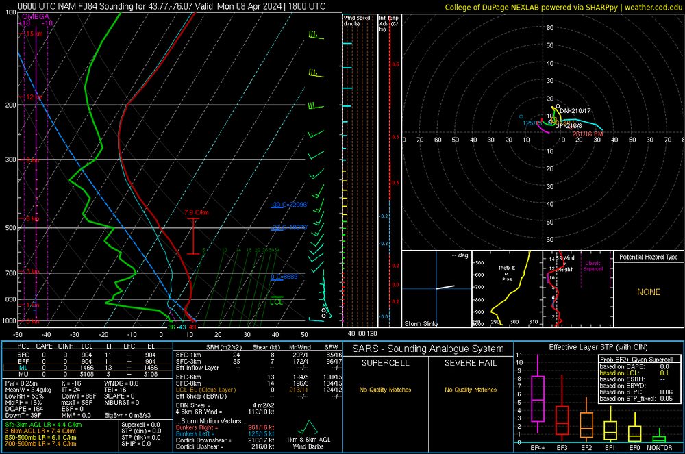
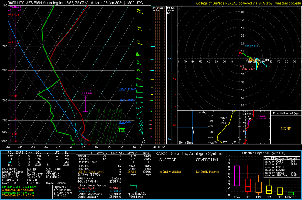
I will hear no slander against the NAM today
Edit: #TeamMeso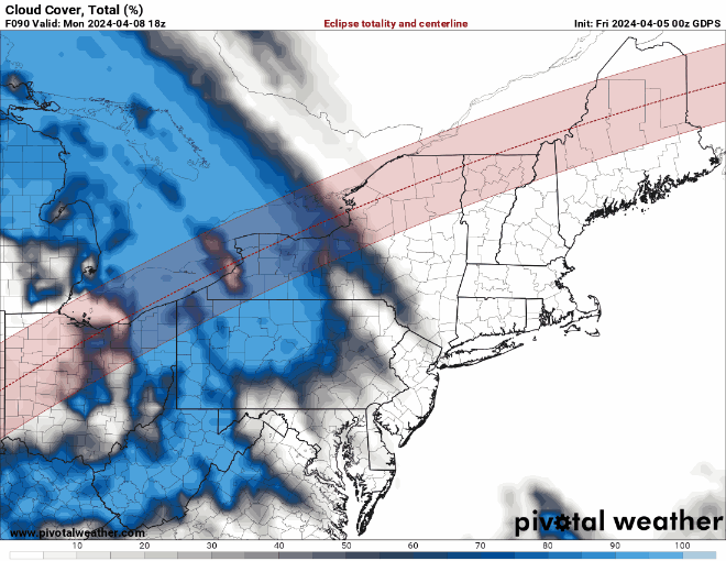
-
1
-
-
4 minutes ago, MN Transplant said:
The OP GFS was trending well until 12z
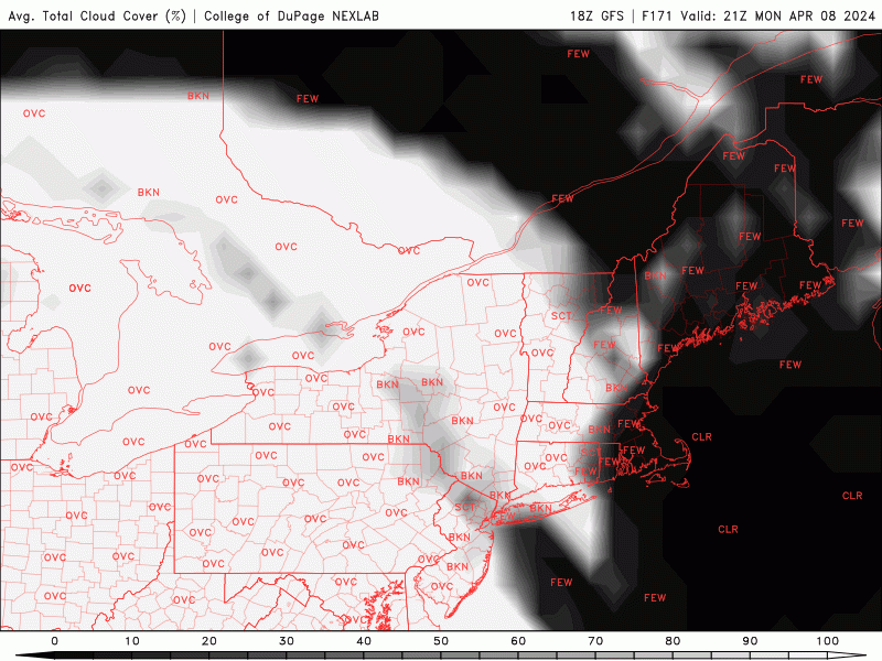
18z ticked the middle clouds further SW, low clouds still not a factor... just super aggressive with the high clouds, despite being a bit drier at 18z. I'm fully onboard the "GFS overdoes clouds, especially thin high ones" hopium train at this point... Here's the GEFS cloud thickness, if it was just the 18z and not time lagged it would probably be a few points higher in most places. Worse for WNY but not as much as the op verbatim clouds would suggest. Hopefully that projected thinness comes through.

-
2
-
-
psst... get excited... 06z tomorrow, NAM range!
-
1
-
 3
3
-
-
1 hour ago, WxUSAF said:
Hugging the hell outta the 12z GGEM
Opposite sentiment... Canadian is by far the most aggressive with the precip moving NE right now
-
2 minutes ago, WxUSAF said:
Tomer’s eclipse city dashboard shows 77% of ensemble members have “favorable” or “somewhat favorable” conditions for eclipse viewing west of Austin. Despite the NBM showing 65-80% cloud cover. So maybe that implies just thin cirrus?? That’s what I’m hoping for at this point. I’ll definitely take the under on just about any prediction of convective cloud cover around the totality path. As I recall from 2017, only the hrrr actually accounted for the reduction in insolation? And it made a visible difference in cumulus coverage.
Yeah there’s definitely some confusing differences between the NBM and tomer’s blend of clouds/shortwave depending on the model. I think NBM is just using clouds? Which could be overdone compared to shortwave. Rochester has the same but smaller conundrum, 70% favorable, 18% somewhat, 12% unfavorable but 51% cloudy on NBM.
I think the trends should bring that NBM down though! Combo of faster movement through Texas and quicker dissipation as things move north east could see both ends of the eclipse path luck out.
-
1
-
-

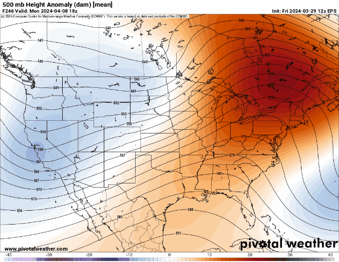
The omega block:

-
1
-
13
-
-
06z GFS continues idea of having the low dissipate before it can traverse the lakes fully which reduces the eastern extent of the cloud cover - using the basic, overdone GFS cloud product. It seems like the bleeding may have stopped for the northeast but for my chosen WNY spot, it has still gone from looking like an 80% or more chance of getting a viewing window to closer to a coin flip. Hopefully there’s a bit of a countertrend today…
-
6 minutes ago, Scarlet Pimpernel said:
GFS continues to look completely awful for the Great Lakes/Ohio Valley area. Just about the worst possible outcome with rain all day as the low goes right through Ohio. Guess we'll see but I don't like the trends in that shortwave that runs into the Omega block, even on the Euro and the ensembles. Although the Euro is much farther northwest with the low and the precip looks a lot more scattered. Almost wonder if it might be better to just stay local here in the DC area and observe a partial eclipse (~87% coverage), and get some photos of that (I have a solar filter for this purpose). At least so far, it looks pretty clear around this region. Might have to see until later in the week. Still may say screw it and go up to see family in Ohio and at least have a fun visit even if it rains all damned day Monday and you can't see anything other than it getting darker.
I think a positive is it got much weaker. For this run, that unfortunately does not help Ohio much. It does improve things further NE and verbatim there’s just a spike of partial high clouds over WNY and then clear rest of the way. Maybe it can trend weaker over the next couple runs and more south and the cloud/rain line can retreat from the Lake Erie/Ontario coastlines.
-
At this point I just hope maybe the trend to squash the whole thing latitudinally might make the clouds a north south dividing line rather than an east west one; I am at this point ready to accept (seethe at) my being screwed in the current longitudinal fiasco and hope maybe to find myself in a better spot if it becomes a latitudinal deal.
-
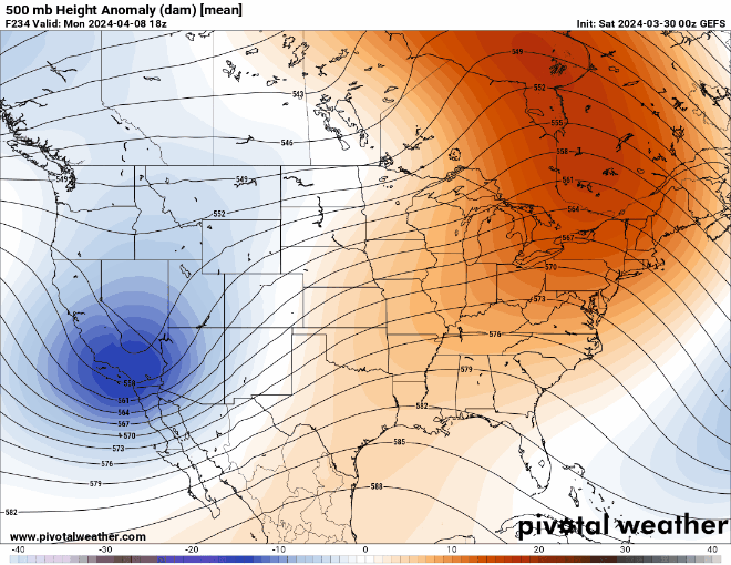
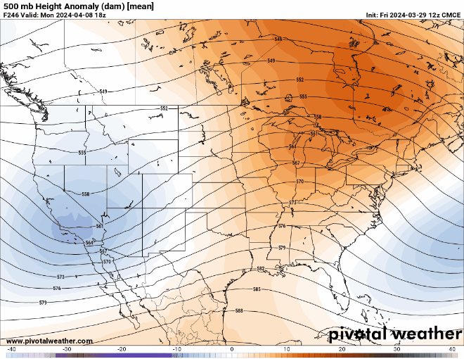
ECMWF took a step in the wrong direction for the northeast.
-
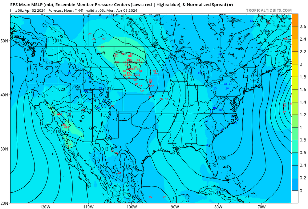
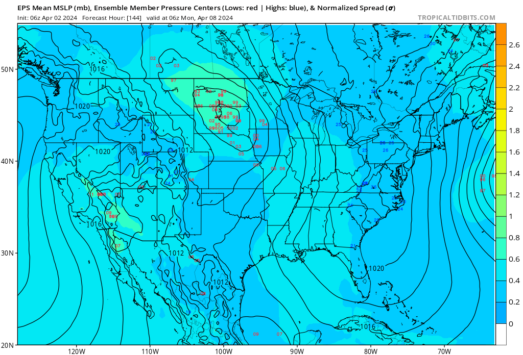
EPS 06z still seems unconvinced by the extreme eastward camp, a touch NW for the low 13 hours before game time. Clustered well around the middle of the Dakotas, nothing east of the Mississippi per lows shown on TT. Hoping the GEFS and GEPS drop their eastern extreme members and cave…-
2
-
-
Alright the models need to quit it with that low barging into the lakes or we’re going to have trouble
-
3 hours ago, bdgwx said:
I was not able to find the downward solar radiation plot. Can you post a link or an brief description of how to get it?
2024 Eclipse Forecasts (ou.edu)
If you go to "Ensemble Forecasts" here, GEFS and EPS have the Downward Shortwave (solar was my mistake) Radiation plots. The GEFS has it because its cloud plot is extremely overdone, and the EPS has it because it does not have a dedicated cloud product otherwise.
Tomer Burg goes into how and why he did it here in this thread:
https://x.com/burgwx/status/1774231279523021285?s=20-
1
-
-
Latest GEFS seems to set up the nailbiter - lots of variance on how the northern low sets up if you look at the member MSLP chart. Just hoping it can't nudge into the ridge so much and set up on the lakes as one camp of members suggests...
-
 1
1
-
-
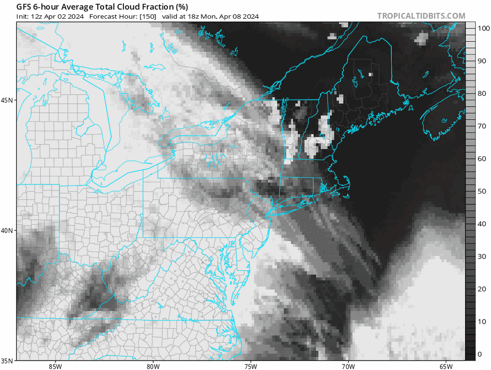
Use the downward solar radiation plot for the GEFS/GFS - it's available on Tomer's site! Tomer Burg uses that to address the GFS and its ensembles having a huge cloud bias. Just compare the GFS and CMC 24 hours out on pivotal on the cloud map, or the GEFS vs GEPS... GFS/GEFS is crazy. Now, for Texas right now that's little comfort as it does not improve the picture much. But much of the path fares better.
-
 2
2
-
-
Slight concern though... I hope the high doesn't trend too far north and let something sneak underneath into the lakes region... that's what I'd be most afraid of.
-
1
-
-


Not ready to put any faith in cloud maps. Willing to use precip as a bit of a proxy for "is it even worth getting hopes up" though...
-
1
-
-
Ridge placement looks improved for the northeast through the 00z ensembles and 06z GEFS. Gotta keep rooting for that low up in Canada to walk back westwards, let that high be totally unmolested! Some PWAT negative anomalies really starting to creep in towards Buffalo now as well, as that shift west moves the moisture train from the gulf farther away.
-
I'm thinking as the solution is zeroed in on, we'll stop seeing the widespread precipitation as the multitude of solutions that are distributed across the members (slower, four corners? slightly faster, affecting Texas? much faster, ejected to the east?) settles into just one. I'm not really concerned with ops, or ensemble precip maps so much, since they show a lot of signatures of individual members... I think looking at the 500mb, you just have to take that big ridge in the east and feel reasonably good about the chances for anyone at or east of the great lakes portion of the track.
-
1 hour ago, nj2va said:
Will be in Niagra Falls Canada so I'm rooting for a fat ol' ridge to park over itself right over the WNY area.
Rochester for me!
-
1
-
-
Cautiously optimistic about WNY with the ridging starting to show up on the ensembles, getting inside 300 and got all 3 votes from EPS, GEFS and GEPS.
-
1
-
-
49 minutes ago, bigtenfan said:
This!!
By the time that the enviornmentalist and their lawyers are done with this it will take 4 years to get permits!
From NEPA: Most Emergency Relief projects and emergency repairs qualify as a categorical exclusion under 23 CFR 771.117(c)(9), which includes the repair, reconstruction, restoration, retrofitting, or replacement of eligible facilities if the work 1) occurs within the existing right-of-way; 2) conforms to the pre-existing design, function, and location as the original; and 3) is commenced within two years of the date of disaster.
Basically, they can avoid a lot of environmental red tape if they largely rebuild the old design, but I think we'd all hope there's leeway to make the supports stronger and then add barriers. I don't think this exception would work if it was going to be a new type of bridge altogether.
-
2
-
1
-
-
On weather - any tips on what long range patterns to look for that might suggest cloudier/clearer (as light a suggestion as that may be at range)? If it’s going to end up cloudy, I’d like to be able to comfort myself by setting expectations early lol.


April 8th Eclipse- Last Easy One To See In My Lifetime
in Mid Atlantic
Posted
Still can see the sun thru the clouds with the eclipse glasses in Rochester, I think pulling off a veiled but still visible totality is possible! HRRR is trending better it seems. Will probs miss out on the corona though.