
.gif.a8150e126cebc480193fad2934fe975c.gif)
Torch Tiger
-
Posts
16,202 -
Joined
-
Last visited
Content Type
Profiles
Blogs
Forums
American Weather
Media Demo
Store
Gallery
Everything posted by Torch Tiger
-
you must be agonizingly close to those showers near I-93?
-
.thumb.gif.f92b16c631a1d15d405ed77b33f0710d.gif)
Saturday 9/6 Strong/Severe storm potential
Torch Tiger replied to Torch Tiger's topic in New England
If only we had respectable mid-level lapse rates. Would most likely have a few discrete monsters -
Saturday 9/6 Strong/Severe storm potential
Torch Tiger replied to Torch Tiger's topic in New England
any damage reports? ..TIME... ...EVENT... ...CITY LOCATION... ...LAT.LON... ..DATE... ....MAG.... ..COUNTY LOCATION..ST.. ...SOURCE.... ..REMARKS.. 0215 PM Tstm Wnd Dmg 3 ENE Ancram 42.07N 73.58W 09/06/2025 Columbia NY 911 Call Center Tree and wires down across the roadway. -
Saturday 9/6 Strong/Severe storm potential
Torch Tiger replied to Torch Tiger's topic in New England
lots of bubbly TCU popping to my west -
Saturday 9/6 Strong/Severe storm potential
Torch Tiger replied to Torch Tiger's topic in New England
first tor warning! -
Saturday 9/6 Strong/Severe storm potential
Torch Tiger replied to Torch Tiger's topic in New England
Yeah decent velocity on that cell near Milan NY -
Saturday 9/6 Strong/Severe storm potential
Torch Tiger replied to Torch Tiger's topic in New England
watch up! SUMMARY...Scattered thunderstorms are beginning to develop along a boundary from central Maryland northeastward into parts of New York/Vermont. These storms will intensify through the afternoon, with locally severe storms expected. Damaging winds will be the main risk with the stronger cells, although a few could also produce hail and perhaps a tornado or two. The severe thunderstorm watch area is approximately along and 60 statute miles north and south of a line from 45 miles west of Wilmington DE to 25 miles east of Bangor ME. For a complete depiction of the watch see the associated watch outline update (WOUS64 KWNS WOU7). -
Saturday 9/6 Strong/Severe storm potential
Torch Tiger replied to Torch Tiger's topic in New England
missed this earlier. 80% Probability of Watch Issuance...80 percent SUMMARY...Strong to severe storm development is possible by early afternoon. Issuance of one or more watches is likely. DISCUSSION...Filtered heating is ongoing late this morning from parts of NJ/eastern PA into parts of New England, to the east of a substantial cloud shield and embedded weak convection. Morning soundings depict generally poor midlevel lapse rates, but relatively rich low-level moisture (with dewpoints in the 60s to near 70 F) and continued heating will result in MLCAPE increasing to the 1000-1500 J/kg range. Scattered surface-based storm development is expected as soon as early afternoon, as a cold front begins to impinge upon this destabilizing environment. Deep-layer shear is already rather strong across the region, and will continue to increase in response to a notable mid/upper-level shortwave trough approaching the lower Great Lakes region. Initial development may quickly evolve into a few supercells, though deep-layer flow/shear roughly parallel to the front may eventually result in a tendency toward storm clustering and possible QLCS development. Some increase in low-level shear/SRH with time could support a tornado threat with any discrete or embedded supercells, especially where surface winds remain locally backed near a weak surface wave that will traverse the front this afternoon. Isolated hail may also occur with any supercells. Otherwise, scattered damaging wind will become increasingly possible with time, as storm coverage increases and low-level lapse rates steepen. One or more watches will likely be issued by early afternoon in order to cover these threats. -
Saturday 9/6 Strong/Severe storm potential
Torch Tiger replied to Torch Tiger's topic in New England
convection looks shallow and meh. hope that ramps up soon -
Saturday 9/6 Strong/Severe storm potential
Torch Tiger replied to Torch Tiger's topic in New England
womp womp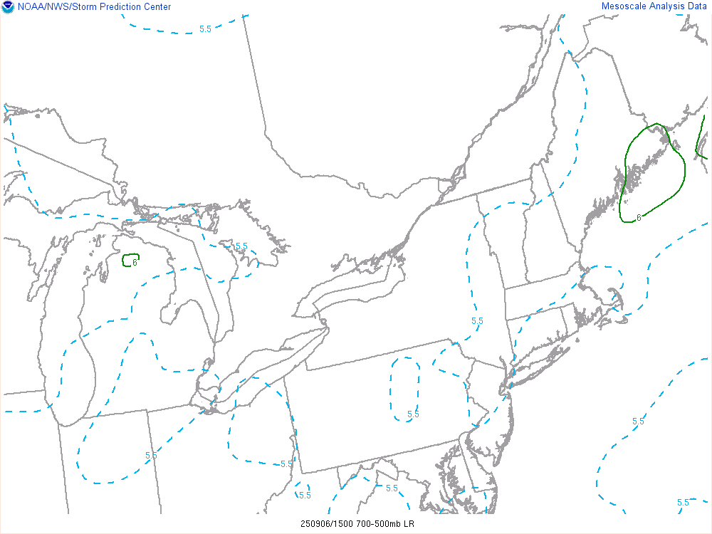
-
Saturday 9/6 Strong/Severe storm potential
Torch Tiger replied to Torch Tiger's topic in New England
Great day to go for a drive even if the storms aren't particularly good. -
Saturday 9/6 Strong/Severe storm potential
Torch Tiger replied to Torch Tiger's topic in New England
Debbie's gonna debbie -
Saturday 9/6 Strong/Severe storm potential
Torch Tiger replied to Torch Tiger's topic in New England
Hrrr is terrible. Hope 3k is right -
Saturday 9/6 Strong/Severe storm potential
Torch Tiger replied to Torch Tiger's topic in New England
Looks and feels like a big day -
9/7/23 was ok
-
Early September is a mini-peak for severe, often as good as it gets around here. 9/7/98 is a great example
-
Saturday 9/6 Strong/Severe storm potential
Torch Tiger replied to Torch Tiger's topic in New England
Mine are bulletproof. Talk to me tomorrow when your roof is in Epsom -
Saturday 9/6 Strong/Severe storm potential
Torch Tiger replied to Torch Tiger's topic in New England
Hopefully a few tors to spice things up. -
-
yeah.
-
Sniffed this out firstly on Monday! Some knew ...Northeast... A wave of low pressure is forecast to develop over eastern PA early in the day, translating northeastward along the front and into ME by late afternoon. Stronger heating and steep low-level lapse rates should develop from VA into eastern PA/NJ and into interior southern New England, with MLCAPE around 1500 J/kg as an areal average. As the warm air mass develops and accelerates north ahead of the cold front, both instability and shear parameter space will become favorable for severe storms, including supercell potential. A line of storms is expected by 17 to 18Z, from eastern PA toward the Hudson Valley, expanding N/S and pushing east through the afternoon. Given 40-50 kt effective deep-layer shear and enhanced low-level shear with the midday surface theta-e surge, the initial storm mode may be cellular along the boundary, with a brief tornado or two possible along with some hail. Damaging winds are then most likely as outflows merge, and spread east across the remainder of the region through late afternoon.
-
Yeah just like that, poof. Nothing to track in the LR. This season blows
-
The coast is never really "favored" versus interior, but the best time of year is typically Aug/early Sept. for coastal areas lol
-
Cloudy and cool in Bedford NH. Misting a bit too
-
I'm hoping the line outpaces models, not really expecting it.


