

tiger_deF
-
Posts
490 -
Joined
-
Last visited
Content Type
Profiles
Blogs
Forums
American Weather
Media Demo
Store
Gallery
Posts posted by tiger_deF
-
-
Just a general meteorological question; I understand that closed low pressure systems tend to form from shortwaves that elongate troughs to the point of separating them from a synoptic ridge/trough pattern and "closes" them off, but how come these low pressure systems tend to intensify so much more, and appear more symmetrical, over water?
-
We just need to stop the bleeding right now
-
 1
1
-
-
My worst fear is that we'll see every subsequent model run back off slightly until by Friday we have a middling event
-
Just now, PhineasC said:
LOL yeah BOS seems kinda suspect on that map.
The Falcons just can't catch a break...
-
Hopefully we see the GFS tick east and slightly deeper to both mitigate some of the mixing issues and keep the shield of precipitation nice and broad. Unfortunately this season the EURO has seemed to follow the GFS more than vice versa, so shifts in this evening's/tonight's runs would be excellent
-
I say we reach 100 pages by Wednesday, forget about in total
-
 1
1
-
-
10 minutes ago, CoastalWx said:
The airmass is not really cold ahead of it. 925 and surface temps out of southwest and mild. As the storm deepens, the cold then gets pulled down. The euro shows this nicely. The GFs does the same, but unfortunately taints a lot of SNE.
So what I'm hearing here is, unlike other synoptic setups of some past storms, is that the stronger the low the less tainting there could be?
-
People are paranoid because this is the kind of synoptic setup that has the potential to truly produce a historic beast... provided that all the factors (northern stream, southern stream, positioning of disturbances, high pressure interactions) line up just right. With models setting expectations this high this early, while the end result could end up being exactly what is modeled now, there will certainly be some movement with us being 5 days out. Getting 6 inches of snow as a max out of this system would leave the board majorly disappointed, while getting 6 inches out of a system that comes out of nowhere would be considered exciting.
-
Just now, Damage In Tolland said:
The danger on this is it keeps coming west. That is real
If this thing ends up in NY/Philly like the abortion a few weeks ago the board is gonna lose it
-
9 minutes ago, weathafella said:
Euro looks like it’s losing this battle. I would love a 2 footer on DC/RIC while New England smokes cirrus to watch the melts…
Look at Mr. Ice Miser over here with snow left to melt
-
I wouldn't be surprised if, given the modeled strength of this upcoming system, if a good chunk of SNE got anywhere from a coating to 3" of snow just from the outer precipitation bands.
-
12 minutes ago, CoastalWx said:
I don't have hopes, but we hope lol. Since I am getting rear ended Monday, would be nice.
Likewise. Almost certainly will whiff, but if you took the NAM and bumped it 50 miles to the west that would be feet of snow for parts of SNE. Just an absolute conveyer belt of moisture
-
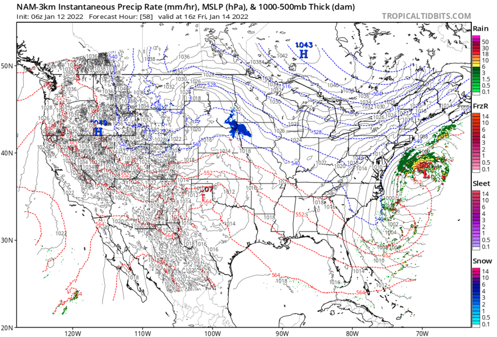
I think our best shot at getting a decent amount of snow from Friday is the system shooting to the North slightly faster than currently modeled. The NW high, with accompanying arctic air, will prevent the system from being tugged West and will in the end force it to the east. One major difference from prior runs in the 3z Nam is the northern flank of precipitation and low pressure advances farther to the North before getting forced west. A stronger system would definitely help with this, so unlike Monday's system we want this to become stronger earlier.
If the shifts that would need to happen (still somewhat unlikely as of now IMO) happen, this storm will catch the general public off-guard big time. Even cape cod weather forecasts have little to no precipitation in the forecast for Friday/Sat.
-
Maybe we can get the best of both worlds out of this pattern, with a mild-medium thump on Friday for eastern areas, and a large thump from Monday's system for Western areas (which received little benefit from the system last Friday).
-
46 minutes ago, ORH_wxman said:
Where are you getting the 12z CMC already?
Apologies, I was looking and comparing the 00z and 12z from last night/yesterday. I do believe that just like with our last storm, the interaction of the lows is going to be crucial to determine the path of the storm, which will best be observed via nowcasting.
-
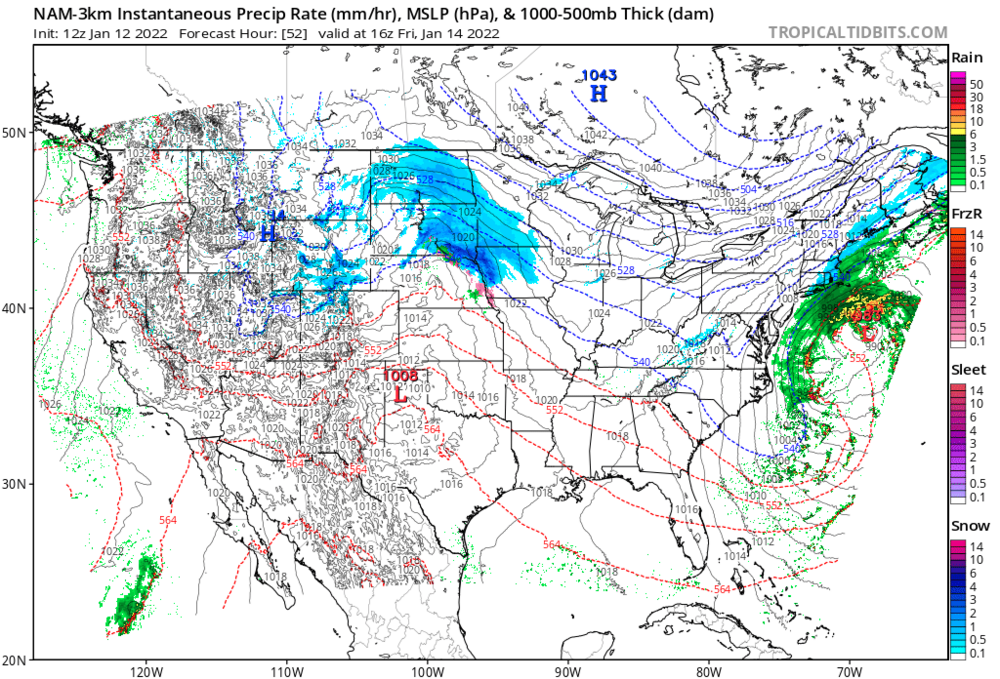
For what it's worth (which isn't much) the CMC also has a substantial West shift for Friday's system, and 12z coats a good chunk of SNE with 2-3" of snow, where previously the edge of precipitation was hundreds of miles offshore
-
Just now, TauntonBlizzard2013 said:
3k NAM offers some weenie fodder for eastern ma Friday
06z vs 12z for reference
-
1
-
-
7 minutes ago, ineedsnow said:
NAM has some snow for eastern areas Friday now
The whole system has been modeled as a mess of lows for a while now, if the eventual low consolidation is West-biased I could see an advisory-level event for SNE in the cards
-
Just now, dryslot said:
Extrapolating is never a good idea but that H5 look would not be any good if that's what JC was looking at.
Maybe he was talking about Friday? Significant west shift, though it's pretty late in the game for enough future shifts to make it an event
-
1
-
-
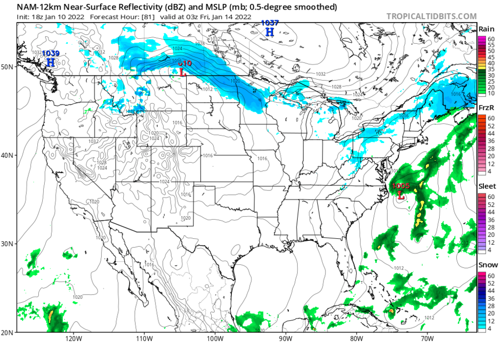
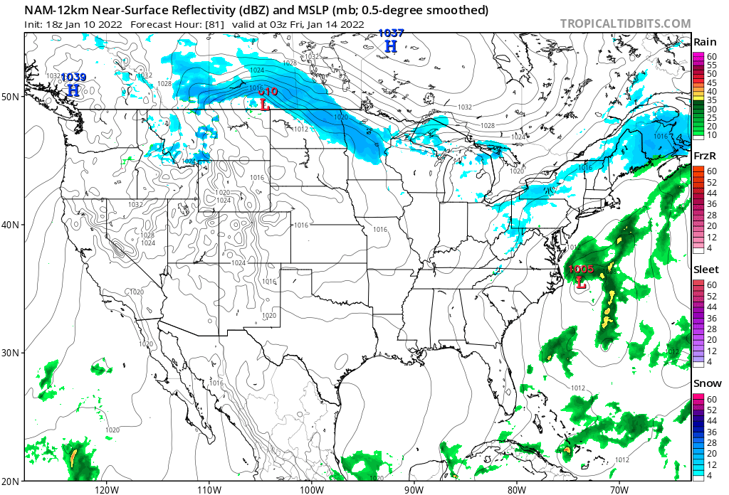
18z NAM at 84 hours is interesting. It's been consistent with showing this low for the past two runs
-
2
-
 2
2
-
-
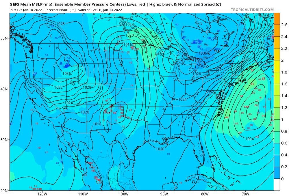
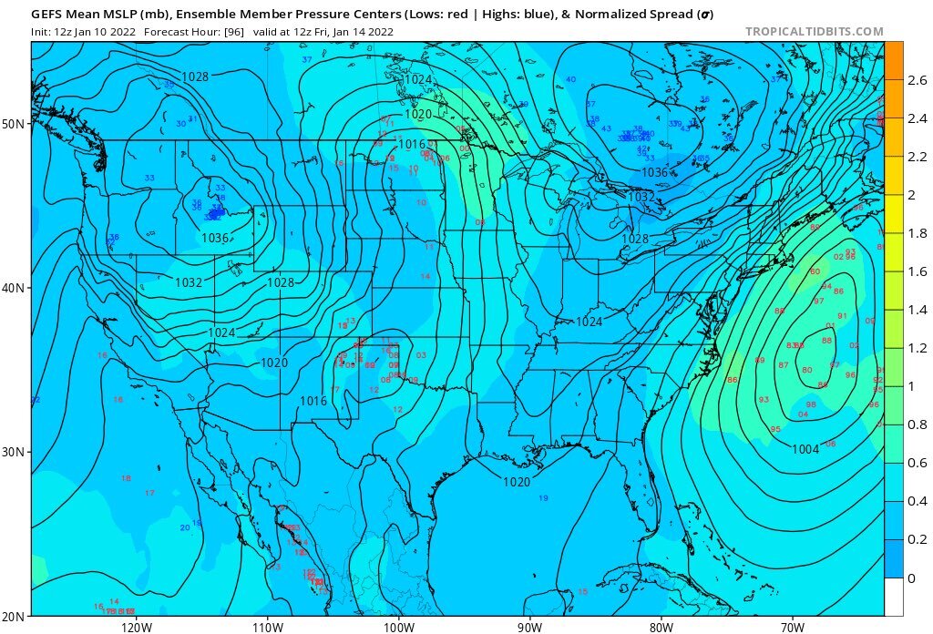
At least the EPS has shifted Friday's event to the West... still need a few more shifts
-
1
-
-
1 minute ago, 40/70 Benchmark said:
Anyone under the impression that Friday or Monday has a reasonable chance to be major is deluding themselves...that's just fact, IMO. Is what it is. Not saying winter is over.
I've come to realize that since there is a 99.99% change nothing we say or think about upcoming weather in this forum will actually change the synopsis, I'd rather stick with delusional optimism than realistic pessimism. I get to ride the absurd wave of excitement leading to an event, coupled with (potentially) crushing disappointment. Much preferable to "meh" which life has too much of anyway.
That being said, I'm cheering on a West shift >50 miles in the 18z suite

-
Just now, ORH_wxman said:
Ukie has a light event for Friday.
What about Sunday? All the other guidance shoots it so far OTS out to the SW that I doubt we would even get cirrus. Definitely favoring Friday, but maybe Sunday-Monday whiffing will help us down down road
-
How many of the EPS ensembles show effects from the storm Friday in NE? Still think that, versus Sunday, is where our bread may be buttered
Also that warm signal at the end of the GFS is no bueno.. shows a coastal storm that literally brings rain to the entire region outside of Northern Maine.


Powerful Multi-regional/ multi-faceted east coastal storm now above medium confidence: Jan 29 -30th, MA to NE, with snow and mix combining high wind, and tides. Unusual early confidence ...
in New England
Posted
If the central pressure of this system ends up near the lower floor of modelled pressures (let's say ~960's mb), what could we expect for maximum winds? Given the current track Cape Cod would probably get the worst of it, but I could see a storm of this magnitude having a fairly large fetch of winds.