

tiger_deF
-
Posts
490 -
Joined
-
Last visited
Content Type
Profiles
Blogs
Forums
American Weather
Media Demo
Store
Gallery
Posts posted by tiger_deF
-
-
Impressive convective pattern

-
Heaviest snow of the day here in Arlington, been shoveling for an hour and there is easily 3 inches of snow on the stairs I shoveled first
-
 1
1
-
-
How many more hours of heavy snow are we in for in Boston?
-
Even if the low is fairly displaced to the East, I'm really hoping we get at least some sort of capture, which would make this storm go from a monster SE snowstorm to a historic one
-
1
-
-
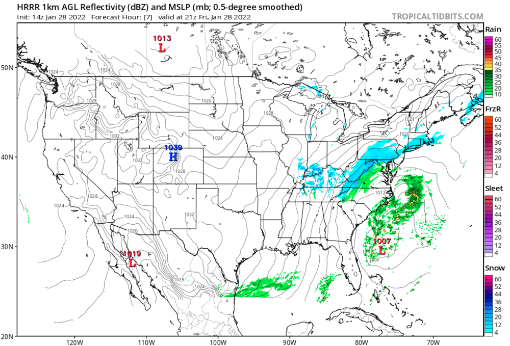
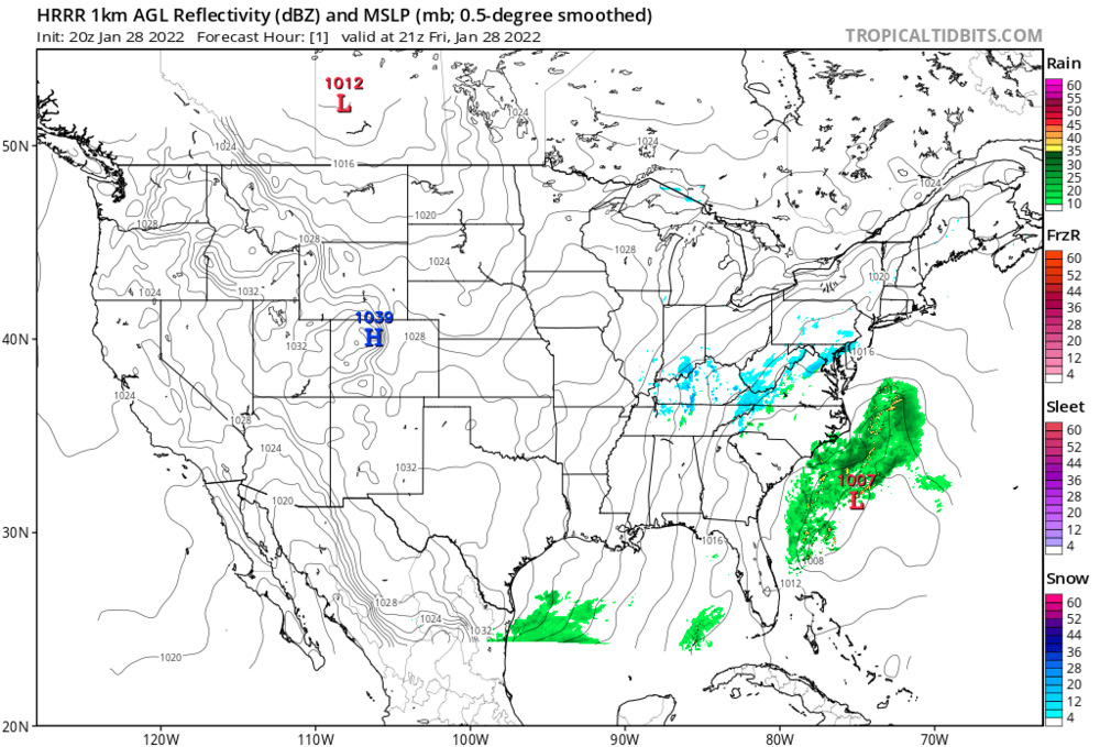
This is shaping to either be a complete bust for the models, of a complete bust for many snowfall maps
-
HRRR for +1 at 14z vs HRRR for +1 now at 20z
-
1
-
-
How's our low pressure system down South looking?
-
GfS looks deeper, and doesn't really trend much through 18h
-
We should really have a nowcast thread so we can observe the development of the low and any possible signs of two lows developing
-
2
-
-
-
Just now, BRSno said:
Really wish I had booked a flight for tonight on Tuesday. Can't wait to live vicariously through you guys.
If this starts trending East on the next GFS run we know why
-
 1
1
-
-
I'm curious to see if the strength of the low will be trimmed up as we head closer to go time, or if it will maintain the low 970's-960's that most of the models strengthen it to. How many sub-970 Nor'easters have we had up here?
-
Do the actual computational models themselves work in 6 hour increments, or is that just how the data is presented? Sorry if this is a stupid question
-
2 minutes ago, PhineasC said:
Anybody got any more of those snowy model runs...?
I'm getting antsy and need a fix, man.
These hours after the GFS and before the ECMWF are truly the dark times
-
1
-
-
5 minutes ago, wxsniss said:
Wow
Metrowest 18z Sat:

From someone still relatively new to meteorology, what about this is so impressive?
-
Just now, TauntonBlizzard2013 said:
The euro ensembles having so much spread are definitely eye opening. Hopefully it’s not setting the stage for a rug pull to a gfs like solution
There was far more consensus on Monday than there is today...
-
Are we writing off a tuck/capture or is it still a possibility?
-
Now watch the Euro do something completely unexpected at the 11th hour and ruin the consensus again
-
4 minutes ago, dan11295 said:
Appears the dual lows may actually be a thing. RGEM/NAM/ICON all show it now. Will have to see how that impacts storm evolution going forward.
On one hand I can see the dual lows robbing eachother of energy and intensity, but I can also see a scenario where they significantly prolong the snowfall
-
1 minute ago, George001 said:
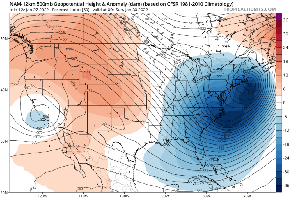
models are underestimating the strength of the low if anything. With the frigid arctic air meeting up with the warm gulf and Atlantic moisture, the atmosphere is primed for extreme cyclogenesis as the trough goes negatively tilted. Low closes off leading to a stall and continued deepening. We also have the wildcard, the PV energy. Right now most models aren’t showing this, but the NAM is very close to having yet another northern piece behind it diving in and phasing into the trough as the low stalls so much that it has time to catch up. If this happens, those totals we see on the nam (2-3 feet eastern mass, 1-2 feet NW) would be doubled. Even as is, there are FIVE closed contours at the 500 millibar. As Bernie Rayno talked about in his livestream, a good rule of thumb is a foot for every closed contour of the upper low. This suggests that the QPF and snow output would likely be higher than shown. Lets see what the Euro does at 12z, if it starts trending towards the NAM, this has a very real shot of going from a “once or twice a decade” type storm to a “once or twice a millennium” type storm. That is where we are at right now, the goalposts aren’t 6-12 inches or anything like we see in normal storms, we are talking feet of snow here.
My mind is telling me no but my body is telling me yes

-
1
-
9
-
-
All the models have massive differences in where they first generate that low off the coast of Fl/Carolinas, until we know just where that low generates there is going to be a degree of uncertainty.
-
1
-
-
Just now, weatherwiz said:
Even at BOS you have a high spread

I have a feeling we still have lots of suprises left, whether good or bad we'll find out
-
1
-
-
Just now, CT Valley Dryslot said:
Why anyone would write a storm off that hasn't formed yet is a complete mystery to me.
We've been really unlucky this year with last minute modeling shifts and storms escaping away to the East. I really think that deep down some people think this one is going to continue to follow the same pattern
-
Just now, RUNNAWAYICEBERG said:
And come here instead…he’ll get a much more accurate take

He'll definitely have much more fun

-
1
-


2022 Atlantic Hurricane season
in Tropical Headquarters
Posted
Given how bearish the board is I was suprised to see our AOI off of Africa looking pretty healthy