

Cary67
-
Posts
1,372 -
Joined
-
Last visited
Content Type
Profiles
Blogs
Forums
American Weather
Media Demo
Store
Gallery
Posts posted by Cary67
-
-
1 hour ago, Baum said:
AFD:FOR THIS FORECAST PACKAGE, SNOWFALL AMOUNTS THROUGH TUESDAY NIGHT
LOOK TO GENERALLY BE IN THE 1-2 INCH RANGE (NO MATERIAL CHANGE
FROM THE DAY SHIFT'S FORECAST), BUT SWATHS OF 2-4 INCH AMOUNTS
APPEAR IN THE CARDS ACROSS FAR NORTHERN ILLINOIS ONCE YOU GET
MORE THAN 20-30 MILES AWAY FROM THE MILD LAKE INFLUENCEZone Forecast:TONIGHT
MOSTLY CLOUDY. SNOW LIKELY AFTER MIDNIGHT. LITTLE OR
NO SNOW ACCUMULATION. LOWS IN THE UPPER 20S. EAST WINDS AROUND
5 MPH. CHANCE OF PRECIPITATION 60 PERCENT.
TUESDAY
SNOW. SNOW ACCUMULATION AROUND AN INCH. HIGHS IN THE
MID 30S. NORTHEAST WINDS 5 TO 10 MPH. CHANCE OF PRECIPITATION
90 PERCENT.
TUESDAY NIGHT
CLOUDY. SNOW SHOWERS LIKELY, MAINLY IN THE
EVENING. LOWS AROUND 30. NORTHWEST WINDS 5 TO 10 MPH. CHANCE OF
PRECIPITATION 60 PERCENT.Time to put distance vs Alek in snow totals
-
 1
1
-
-
2 hours ago, A-L-E-K said:
They were p fun, minus the whole cary grove part, couldn't get out of that shithole fast enough
Going dab final call 4 next week
Culture has arrived. They even built a new fine arts center

-
1
-
 1
1
-
-
19 hours ago, CheeselandSkies said:
Kinda sorry I missed that, but I'm currently at a resort in Puerto Morelos, Q.R., Mexico and just had my first ever professional massage earlier today, so I'm not really jealous.
Sent from my Pixel 4a using Tapatalk
Nice. Spent some time at the Iberostar Paraiso Lindo a few yrs back in that area. Enjoy
-
1
-
-
Not looking forward to flying out of ORD early tomorrow morning.
-
43 minutes ago, A-L-E-K said:
Wholesome tree talk > banal lawn talk

-
1
-
-
Don't recall any significant October or early November snows in these parts leading to great winters but will leave that to the stats guys.
-
11 hours ago, Baum said:
The BAM map looks more like a layout of each snowfal that fell in the LOT area last snowfall season. Minus the overdo in Mchenry county.
Exactly
-
On 9/24/2022 at 3:50 PM, Baum said:
1. Models show a Oklahoma hooker 4 days out. Complete model consensus for my back yard.
2. As the hooker organizes in the desert southwest an energized clipper rides down and lays a 4" blanket of powder down and storng winds from N-NE usher in arctic air.
3. In clippers wake on going snowshowers blow in from Lake Michingan.
4. 48 hours out all models consensus 12"-18" swath of 15:1 ratio snows with winds in excess of 35 mph sustained.
5. 24 hours out complete model consensus on a blizzard. Consensus so strong no board arguments as a my backyard as the lollipop is a lock.
6. Blizzard warnings issued. Snowshowers begin to increase off lake as storm intensifies over Texarkana. Kansas City already shut down due to 5 hours of 2" per hour rates and thunder and lightning.
7. Gametime. Radar lit. Winds howling. Businesses closing in preparation. Snow begins in earnest.
8. After 12 hours of non stop snow/wind/ thunder 19" has fallen citywide. Drifts 5-6' in areas.
9. Complete forecast verification. High spot downtown Chicago with 26" amounts due to lake enhancement. Mchenry County and Cedar Rapids IA are the lower end of the spectrum with 4" and 6" respectively. Mets can't explain the phenomenon.
10. As the storm winds down, another organizes over Colorado.
Pulling out Ouija board to conjure up the winter spirit of 2007-08. Mchenry Co. will reign supreme again.
-
1
-
1
-
-
Some pea sized hail here
-
5 hours ago, SchaumburgStormer said:
Going to be another rinse and repeat season.
- Warm snowless November
- Warm snowless December - "I'm dreaming of a brown Christmas..."
- Hoosier starts talking futility records in snowless start to January
- Snowy February
- Snowy March
- Snow in April, dear god make it stop
- Cold start to May
Copy and paste for 2023-24?
-
1
-
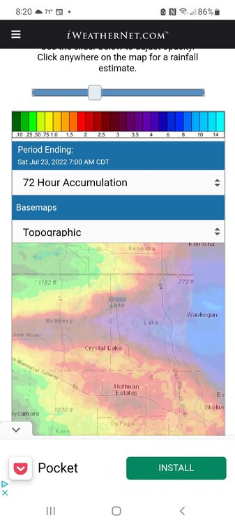
Making up for drought in extreme N.IL from last summer. Keep getting decent rains. About 2.5" here this evening.
-
1
-
-
4 hours ago, Hoosier said:
Took me a sec to realize why 8/28 seemed like a significant day. Then I thought oh yeah, Plainfield tornado. 32 years.
Plainfield and Oak Lawn are basically 1a and 1b for me as far as historical tornadoes in Chi metro, because of the amount of death and destruction caused by each. Everything else is in tiers below that with the possible exception of the 3/28/1920 tornado that went through western/northern Cook county.
Even though Plainfield was F5, I don't know if I'd call it "worse" than Oak Lawn. That F5 was based on damage to a field, not to any of the buildings, so it's quite likely that the same tornado today would not be rated over EF4. I think the Oak Lawn F4 rating would probably hold up as EF4 though as some of the damage in Oak Lawn looked pretty extreme, at least based on pics. Plainfield does have the out of season claim though, as it's extremely rare to get something of that magnitude at this time of year (especially in IL).
Remember that day well. First year medical student at Loyola Stritch in Maywood in 1990. Hospital went on full alert to receive trauma patients.
-
12 hours ago, A-L-E-K said:
More micro storms
Managed to hit on a few of those
-
1
-
-
11 minutes ago, canderson said:
The reason for the trip is an event in Chippewa Falls - trust me the brewery is on my list
Brits Pub was unique with multiple levels and within walking distance of Target Field
-
1
-
-
19 hours ago, canderson said:
Hey hey! Random but I’ll be in the region in two weeks - Eue Claire for 3 days and Minneapolis for 1. Any suggestions on anything to do at either or in between? Seeing the Sox vs Twins game the night we”re In Minneapolis, staying at the new Four Seasons. Any tips on good bars around?
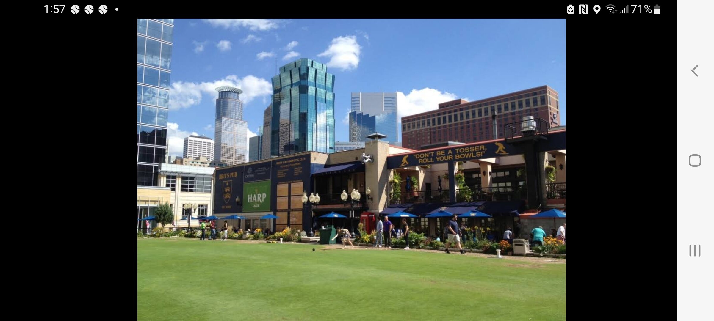
In nearby Chippewa Falls outside of Eau Claire is the Leinenkugel Brewery. Could do tour or just sit in their bar/ gift shop area and drink. If you golf Wild Ridge GC pretty stout challenge. I've rented a pontoon boat on Lake Wissota if you like boating. Target field is nice went to a bar downtown Minneapolis called Brits Pub. Has cool criquet lawn with seating to drink on the roof.

-
1
-
-
On 7/25/2022 at 5:12 PM, Chambana said:
Can’t believe next week is August. Good lord Summer ‘22 is flying on by.
It's been a good summer here. Any real heat has been short lived with timely rains to keep drought prospects away. Would like to see more tstorms but we've had a few decent rds.
-
3
-
-
29 minutes ago, tuanis said:
7” of rain, 4 rounds of hail, somehow we didn’t flood but it came so damn close. I’m exhausted from preparing the house for water all night, and now another noisy cell pops overhead.
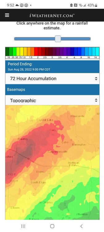
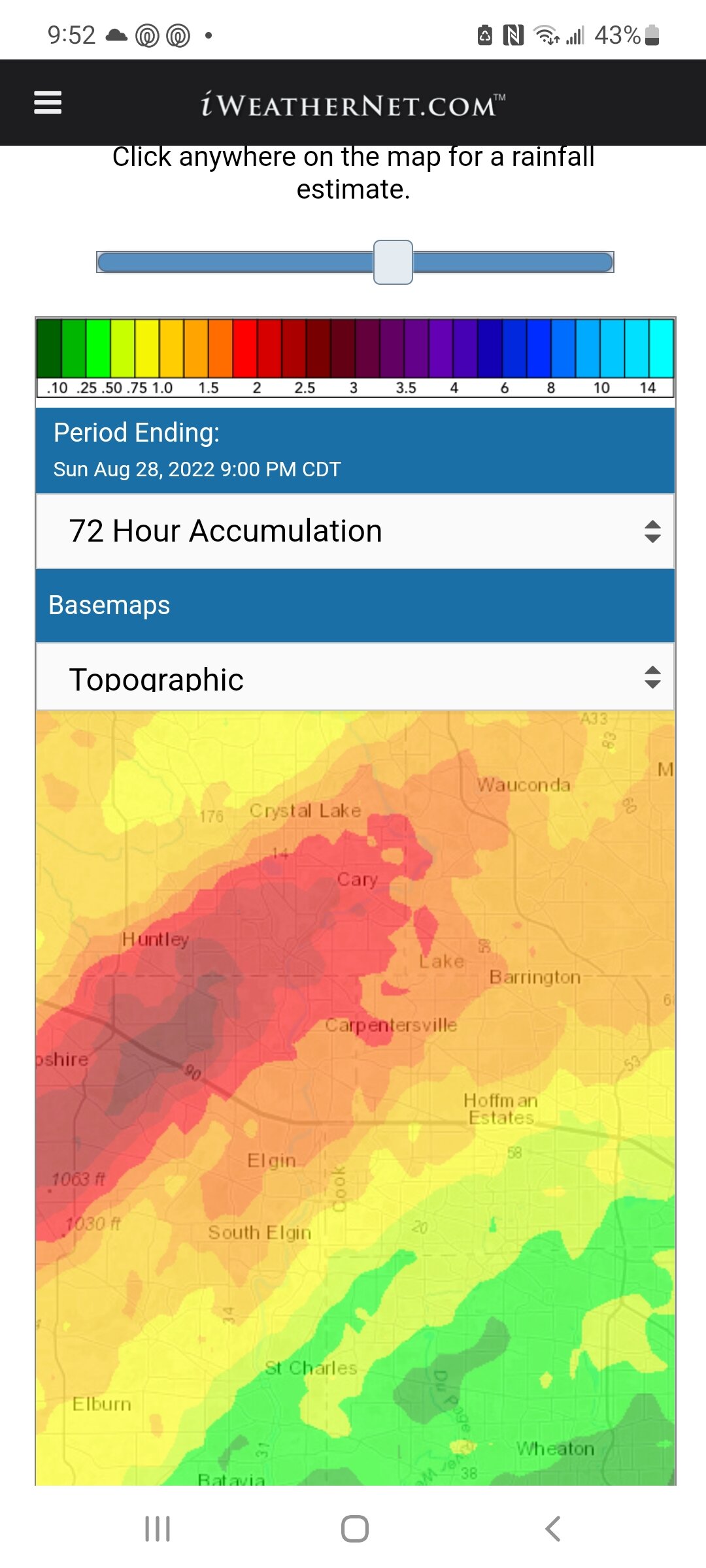
Looks like worst of it skirted just north of here and hammered Lake Co
-
1.3" of needed rain
-
1
-
-
25 minutes ago, WestMichigan said:
Would be nice if we could share the wealth a little. Many areas in the have and man areas in the have not categories right now.
Hopefully some rain comes your way soon. Can empathize after our drought conditions in extreme N.IL last year
-
1.6" rain here last night. Two day total of 3.9"
-
1
-
-
2.3" rainfall last night. At one point we had a water main break on our street with no running water and power was out last night. Village workers were there in some nasty weather finishing the repair.
-
Lost power under severe tstorm warning. Looks to be training over us for the next few hrs
-
2
-
-
51 minutes ago, Baum said:
should I water the flowers? Was hoping for a good soaking, but the board optimism seems to waning a bit.
Watered the lawn last night anticipating convection weakening as it arrives here today. Wondering if we miss tonight NE as LLJ points more to southern lower MI
-
A bit off topic but reports of a large meteor spotted around the Chicago area.
-
1
-
November 15-16 Snowfall Potential
in Lakes/Ohio Valley
Posted
Maybe an inch here.