

Cary67
-
Posts
1,372 -
Joined
-
Last visited
Content Type
Profiles
Blogs
Forums
American Weather
Media Demo
Store
Gallery
Posts posted by Cary67
-
-
16 minutes ago, kevlon62 said:
Around 6 inches down and now coming down heavy again. We had a nice rally band around the 4 a.m. hour that tipped the scales - school called off. Maybe we make a run at 8 inches based on what's still upstream.
Sent from my SM-G935P using Tapatalk
Wonder if we switched to rain here overnight since you had quite a bit more
-
3" down here. Maybe squeeze out one more.
-
-
Radar looks pretty patchy. Alot of lulls.

-
 1
1
-
-
LOT just pulled the trigger on a WSW for McHenry Co. Maybe a case where extreme SE Mchenry not warranted for snow amts. but lumped in with areas further west.
-
5 minutes ago, Chicago Storm said:
The really sharp cutoff will be around DeKalb up to Fox Lake it looks like, for now.
Ouch that's painful
-
-
39 minutes ago, michaelmantis said:
25, heck 10 miles will make a huge difference in parts of extreme NE IL.
I am 15 miles west of you, if I had to guess now both of us end up with an icy sloppy mess for most of this followed by 2 inches of snow and the tail end. Basically icing on the cake to give a fluffy snow layer to the cement that will form.
Anyway, we should know by mid afternoon areas that are trending cooler/warmer than expected.
This is one of those days where comparing model positions makes all the difference to the Nowcast:
Will have to see if there is a difference that sets up just in the distance from Elgin to Cary
-
May get interesting for my area.
-
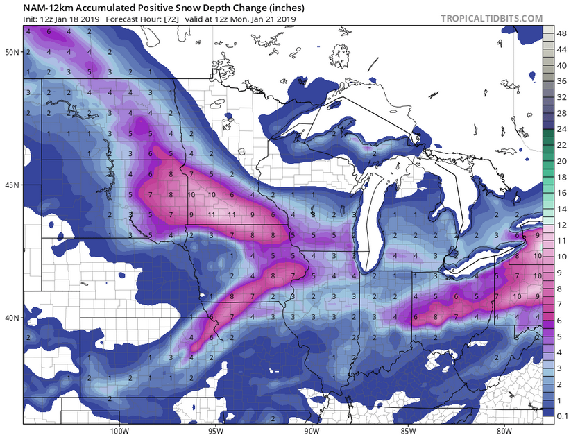
Skilling looked like he was using the latest NAM runs. Had areas in the NW burbs staying in snow for alot of the event. Rockford, Bevidere,Crystal Lake coming in between 5-6". Will see if this verifies.
-
-
About 7.8" down. That should be the storm total as LES should not affect my area.
-
Looks to have been crushed overnight. Still snowing. Will measure after coffee

-
38 minutes ago, Chicago Storm said:
RAP/HRRR/NAM all in lock step for 6-10" along and north of I-88 in N. Illinois, with the highest toals in a narrow gradient from the Quad Cities to just north of ORD.
My radar says it's not happening in imby. Lol

-
Just now, SchaumburgStormer said:
Red flags coming from about every direction to lower expectations locally.
No faith in the Euro.lol

-
10 minutes ago, whoosh said:
Will see if FGEN band stays north or hits our area as depicted earlier. You can usually find some short range model on a particular run that disagrees with prevailing thought. Funny at longer range posters tend to find the model scenarios that optimize snow possibilities whereas at short range the globals plus short range models give us a lot more looks to discount it.
-
24 minutes ago, Chicago Storm said:
I would say that...
Most recent pure LES occurrence was 3/13-14/17 for those areas, which did provide accumulation. Actually had a couple inches of LES from that here as well.
.Yeah lived here since 2002 and can't remember any LES events of consequence this far west. Remember you from accuforums back in the day circa 2007/08. That winter was kind to our area.
-
18 minutes ago, michaelmantis said:
So is the right way to read this is the yellow is just lake enhancement in the first wave and any potential lake effect isn’t included?
What a change from overnight. The enhancement goes pretty far out west.
Elgin and Cary could receive lake enhancement but too far west for LES. Have received some flurries from LES. Think of 294 and east for LES.Still suspect of hi-res models since Euro holding steady further south and has been the most consistent. NAM can be volatile.


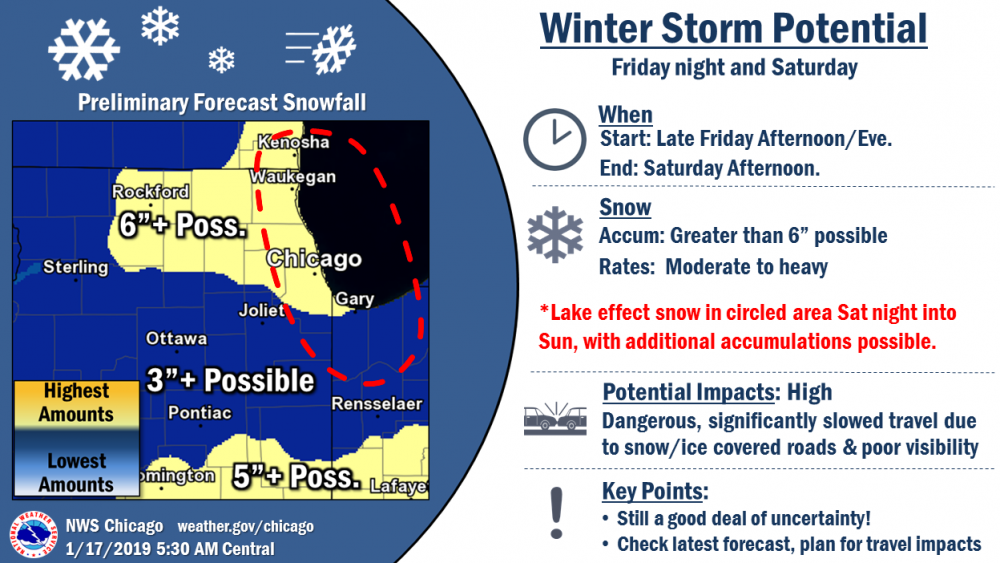
January 21-24 Winter Storm Potential
in Lakes/Ohio Valley
Posted
There was alot of dry pockets in the bands here also