

Cary67
-
Posts
1,479 -
Joined
-
Last visited
Content Type
Profiles
Blogs
Forums
American Weather
Media Demo
Store
Gallery
Posts posted by Cary67
-
-
4 minutes ago, A-L-E-K said:
even euro down to 3 or so lakeside and dropping each run, gonna be another $$$ call
looking like cyclone will play the detroit role this storm and manage a decent hit from a dud
At some point the Euro will come in with a negative snowfall. It will actually remove existing snow from the ground.
-
 3
3
-
-
We have <1" probably
-
This point click forecast not too optimistic

-
The spin machine is on full tilt.
-
2
-
-
19 minutes ago, A-L-E-K said:
ride it


Married to the sref plumes and cousin to the NAM. Cut off timewise a bit early to 2nd wave
-
 1
1
-
-
1 hour ago, A-L-E-K said:
Call is looking $$$
Plume mean looks about 1.9 on the nose and taking the most dud like route to get there
Euro gonna shit the bed like usual
The essence of Jerry Taft lives on
-
 2
2
-
4
-
-
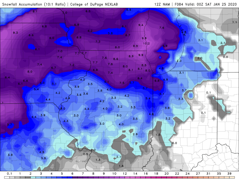
18 minutes ago, hawkeye_wx said:
At the end of the NAM run, there is still solid snow falling from Cedar Rapids to Chicago/Milwaukee.
The last snow system lasted four hours. This week's event has the potential to last 60 hours. Now, if we could just pair the 1"/hr rates from the last event with the 48+ hour duration of this one, we'd really have something.
Have to admit I am skeptical of some snow event lasting 60hrs. And the NAM at this range whatever it shows is toss worthy.
-
1
-
-
13 minutes ago, ILSNOW said:
12z NAM response to ALEK
Cherry picking for a 12ZGFS clunker
-
Starting to snow again. Seasonal total 17"
-
Reached 5" here last night. Now its compacted ZR snow melted sludge.
-
 1
1
-
-
15 minutes ago, RCNYILWX said:
Are you in McHenry County too? I was gonna relay some reports to the office
Sent from my SM-G965U using Tapatalk
Yes SW corner of Cary
-
1
-
-
4" down here. Still +SN
-
1
-
-
Moderate snow continues
-
1
-
-
Moderate snow here
-
2
-
-
21 minutes ago, A-L-E-K said:
the real question, will i see flakes before it gets dark
Fortunately if IL legislators have their way it wont be as much of a problem next year.
-
3 minutes ago, CoalCityWxMan said:
Just judging by the posts in here I fully expected models to show a pathetic outcome for LOT atleast before I checked but it seems about the same/slightly better even than last night on most hi res guidance atleast. I know it’s certainly been the trend lately but

Hedging on their emotional buy in. If it underperforms- told you so. If it meets forecast or overperforms here come the photos and gleeful posts that models finally got something right this god forsaken winter.lol
-
3
-
1
-
-
1 hour ago, Baum said:
your good for 5". MBY...not so much.
Hopefully it will be a spead the wealth system across the metro
-
23 minutes ago, weatherbo said:
Nice long duration event with 12-14" (or more) likely before things wind down on Sunday. Cold this morning, -6.
You do well synoptically with mild winters. Looks good for you the rest of the month into early Feb. Getting ready to use the umbrella again here save this system for the rest of January
-
1
-
-
1 hour ago, jlauderdal said:
1-3 event for metro chicago, models heading in the wrong direction for anything more

-
1
-
-
5 minutes ago, ChiTownStorm11 said:
Garbage

Better drive to Starved Rock State Park to get in on the action
-
 1
1
-
-
25 minutes ago, Stebo said:
Not a good look for your call.

No worries winter storm Alek is on the horizon

-
1
-
-
21 minutes ago, Chicago Storm said:
You can say that about any snow then.
We track it, it falls/accumulates, then it melts.
Not referring so much to the tracking of it meteorologically but in recreational use and shelf life. Surely snow falling Dec-Jan has a better chance of sticking around than in May. You know those picturesque winter landscapes Beavis dreams of.
-
1
-
-
LOT will continue to pay for Halloween storm till around St. Patricks Day. There's nothing quite as useless as Halloween and Easter snow
-
1
-
2
-
-
30 minutes ago, DaveNay said:
LOL @ Cook County

Donut hole moved from Cook to Mchenry Co. 6Z Euro looks like it has a bit of a dry slot pointed toward same area


January 22nd-25th Winter Storm Potential
in Lakes/Ohio Valley
Posted
Huh..have about .5-.75" down here