

Cary67
-
Posts
1,479 -
Joined
-
Last visited
Content Type
Profiles
Blogs
Forums
American Weather
Media Demo
Store
Gallery
Posts posted by Cary67
-
-
2 minutes ago, UMB WX said:
Holy shit that was a brutal last 2 pages. guess we need some model skill classes
Small melt downs are good for the soul.
-
 1
1
-
-
1 minute ago, Sciascia said:

Is the NAM slowing this event down?
-
5 minutes ago, Baum said:
if your so sure on the UK solution which is still an outlier, though a trend southeast has been apparent vs. a trend NW by all models yesterday than you certainly cannot discount the far north solution of the GFS which has been the most consistent. A consensus puts you at 5-10". I think your okay. That said, it's weather so it could crash and burn. If so, motor on...because today was a nice taste of spring, and I love that too.
Can't discount the GFS and would reasonably expect models to slightly wobble back north by tomorrow evening. But this year seems to be the winter of SE weaker and lame so the Ukie represented that. Went for a walk today it was nice. Golf seems far off though.
-
6 minutes ago, Baum said:
would you say you've been modeled consistently for 5"-10" for the last 48 hrs?
Not by the Ukie. 1-2". A little more SE shift and weakening by 0Z Euro and your there. Also MKE area in the same boat.

-
If anything the volatility of these models would indicate NWS offices should issue winter advisories no sooner than 12 hrs out. For this event nothing sent out till tomorrow afternoon or evening for LOT.
-
12 minutes ago, StormChaser4Life said:
I think GFS is northern outlier and Euro likely a south outlier. I'm thinking something in between, I feel like NAM is closest to that in between. Crazy how bad model guidance has been all winter
I thought the Ukie was the southern outlier?
-
Ukie gaining momentum. Starting to take control of the fight. Pull a little on the loose string and it all falls apart.
-
Just now, UMB WX said:
One more Euro run south and we'll be toasting the UK with the Crown
Oh yeah. Holding to that 2.5" call
-
1
-
-
3 minutes ago, SchaumburgStormer said:
I like our general location. North of the south outlier, south of the north outlier.
In all honesty we seem to be in a good spot. Will see if Euro stays the course
-
7 minutes ago, A-L-E-K said:
the mimillman madison special vs cary#s ukie ridin' showdown is good
Ukie's calling all the models home for supper but their late and the food ran out. Ukie has me busting high on my 2.5" call
-
4 minutes ago, ILSNOW said:
And the watches begin
URGENT - WINTER WEATHER MESSAGE
National Weather Service Quad Cities IA IL
1035 AM CST Sun Feb 23 2020

...HEAVY SNOW POSSIBLE MONDAY NIGHT THROUGH EARLY WEDNESDAY...

.A slow moving winter storm system moving out of the southern
plains is expected to bring snow across eastern Iowa and
northwest Illinois Monday night, which will continue through
Tuesday night. Precipitation will start out as rain during the
day Monday which will change to snow Monday evening. Snow may be
moderate to heavy at times, especially Tuesday through Tuesday
night. Increasing north to northwest winds may cause blowing and
drifting snow Tuesday night into Wednesday morning.

The storm has the potential to be one of the strongest winter
storms of the season so far. While it is too soon to determine
specific snowfall amounts, there is above average confidence that
this system will produce heavy snowfall amounts over portions of
the watch area.

IAZ063>068-076>078-087-088-ILZ002-007-009-015-016-024-240045-
/O.NEW.KDVN.WS.A.0003.200225T0000Z-200226T1800Z/
Iowa-Johnson-Cedar-Clinton-Muscatine-Scott-Keokuk-Washington-
Louisa-Jefferson-Henry IA-Stephenson-Carroll-Whiteside-
Rock Island-Henry IL-Mercer-
Including the cities of Marengo, Iowa City, Tipton, Clinton,
Muscatine, Davenport, Bettendorf, Sigourney, Washington, Wapello,
Fairfield, Mount Pleasant, Freeport, Mount Carroll, Sterling,
Moline, Rock Island, Geneseo, and Aledo
1035 AM CST Sun Feb 23 2020

...WINTER STORM WATCH IN EFFECT FROM MONDAY EVENING THROUGH
WEDNESDAY MORNING...

* WHAT...Heavy snow possible. Total snow accumulations of 6 inches
  or higher possible.

* WHERE...Portions of east central and southeast Iowa and
  northwest Illinois.
If its too soon to determine snow amts its too soon for a WSW. Why not issue them tomorrow after 12Z runs to see if it holds up then warnings Monday evening or early Tuesday?
-
 1
1
-
-
Uncle Ukie calling the models home.lol CMC first back
-
1
-
 1
1
-
-
19 minutes ago, A-L-E-K said:
still a little room on the hype train if you want on
Will board the train 12Z Tues. when WSWs are in place. We still have 36hrs to watch mesoscale models contradict globals and for people who thought they were out of it to gain temporary hope.
-
2 hours ago, A-L-E-K said:
Gonna be sad when the euro does its usual shave off 10% of qpf each run routine starting at 12z. Still liking my call imby and somewhat discounting big dog amount 1'+ this far south, liking far nw burbs / s wisc to jackpot around 10.
Hopefully the snowy solutions gain some consensus soon, hard to trust the euro lately
EDIT: catching up on 6z guidance, NEST was hotness and GEFS appear to have taken a big step towards big hit based on freebies.
Tue night into Wed accum snow event. More than enough model run time to tame this thing.
-
1
-
-
1 minute ago, hawkeye_wx said:
00z UK - Slight improvement, but STILL weak and well southeast of the other models.
My guess is amts will generally decrease as we draw close to the event as well as margins will narrow. Ukie still offering a lame way out.
-
10 minutes ago, Baum said:
Haven't really seen a good meltdown in a while despite the general futility of this winter. Definitely, seeing some cracks in this post. I suspect this storm could be the one to really push some folks over the edge given it's potential.
We need Beavis for some perspective
-
2
-
2
-
-
34 minutes ago, hawkeye_wx said:
Madison has been hot recently.
That area and pts north have been favored area this winter.
-
48 minutes ago, Stebo said:
Look for 0Z GEFS trends towards a dud. Models all over the place. Watch Euro be SE and weak no phase.lol
-
1
-
3
-
-
1 hour ago, SchaumburgStormer said:
I won't get sucked into watching another storm shit the bed... I won't get sucked into watching another storm shit the bed...

Too many days..too many ways. Initial call 2.5"
-
1
-
-
I can cherry pick ensembles to keep this thread going for days
-
2
-
 1
1
-
1
-
-
1 hour ago, Baum said:
that euro ensemble is what i envision
Dealing out false hope is my business
-
1 hour ago, Baum said:
Bomb somewhere. All patterns die eventually. Concern is an east coast theft. And yes, it will be an amped rainer and 1-3 incher for those directly under the storms path.
Here it is on one of the Euro ensembles


-
5
-
-
1 hour ago, Baum said:
too soon per the euro.
Uncle Ukie still has your back. This winters trademark has been amped up systems that cut hard.:)
-
1 hour ago, cyclone77 said:
Lol. They need to just cut their losses and decommission the current version of the GFS, and put the old version back in use. Time to go back to the drawing board boys.
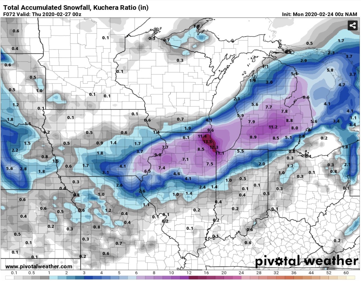
Amts.are absurd but likely to see more accumulating snow for that corridor. North central Wi. from Madison up to Wausau, Green Bay, Rhinelander all above average snow wise. Here a couple rainers to end February then maybe a few slider/coastals for early March. Only 7 more weeks to mid late April and spring. Until then enjoy Thanksgiving weather but with more daylight.
.
-
1
-
 1
1
-


Mid-week potential of something somewhere
in Lakes/Ohio Valley
Posted
Did the GFS slow down also and phase later like the NAM?