
Steve25
-
Posts
587 -
Joined
-
Last visited
Content Type
Profiles
Blogs
Forums
American Weather
Media Demo
Store
Gallery
Everything posted by Steve25
-
I got a pretty good kick out of the 6z FV3 showing rain and 57 degrees at 1 AM next Sunday, then 25 degrees and heavy ice/snow by 7 AM. Then later in the run had temps around -15 LOL.
-
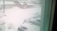
Measuring about 4.5 inches in the grass, with an inch less on the pavement in Baltimore. Not sure if I should be expecting more accumulation throughout the day.
-
I'm north of Baltimore City and I'm still getting moderate snow with big flakes. I looked at radar a few hours ago and figured it was almost over. I must literally be right on the edge of the snow.
-
Is it ridiculous that I'm worried about falling asleep because I don't want to wake up to brighter skies and melting/compacting snow in the late morning? It's one of my nightmare scenarios whenever there's overnight snow.
-
Trying to keep myself up because I don't want to miss what may be the best part of this storm. I don't know if I'll make it.
-
I'm not nearly as educated in this as most of you, but I notice a smaller event around Friday. Do you see that as impacting the potential Sunday storm in any way?
-
Near Baltimore City, I'm probably somewhere around 3" on the grass. I will say though, roads look like they're going to be okay. Even my side road was getting white but salt truck cleared it right up. I have to imagine the main roads are fine.
-
I'm the same way!
-
Very fine flakes just starting in Parkville. Just Northeast of Baltimore City.
-
Do you guys believe in the idea that the final product will be a tad north of what the guidance is showing?
-
Long time observer, new to replying. Just wanted to thank you all for the constant flow of information! I had a question, I use Tropical Tidbits for my weather models. It's free so it doesn't have access to all the models a lot of you have access to. I'm wondering what sites you use because I'm willing to pay to get an upgrade in that department.


