

NYCweatherNOW
-
Posts
1,313 -
Joined
-
Last visited
Content Type
Profiles
Blogs
Forums
American Weather
Media Demo
Store
Gallery
Posts posted by NYCweatherNOW
-
-
7 minutes ago, HeadInTheClouds said:
I agree with all the previous posts about the GooFuS. It's not very good but the FV3 which is supposed to replace it is worse IMO.
The only thing is the FV3 got November 15th snowstorm right. Besides that it’s just as bad imo
-
 1
1
-
-
14 minutes ago, allgame830 said:
The GFS is the only model showing this at this point.... continue to toss!
Sometimes the GFS only completely catches on once the event has begun LOL
Gfs during the November 15th snow event initialized during the storm as rain meanwhile we were getting a snowstorm. I hate that model
-
1
-
-
Just now, ny10019 said:
dumb question what is a CAD
Cold air damming
-
1
-
-
Just now, NJwx85 said:
The problem isn't surface temps.
This is what's driving all the precip and it's mostly at the 850mb level.

The 850’s will cool too with the pv pressing like that. No doubt we’ll have a battleground between snow and sleet for a bit around jfk area but in my opinion this is mostly a snow event as it stands to me. Still plenty of time to change
-
 1
1
-
-
9 minutes ago, NJwx85 said:
Now this is what I'm talking about. 18 degrees in Rockland County and it's only 06z Sunday.

U see how the last frame the Pv presses and it cools down
-
1
-
-
19 minutes ago, White Gorilla said:
I respect your opinion and I hope it comes true because snow is way better than ice and nobody wants a rainstorm. However, for my own education, I would like to know what trending global indeces lead you to believe in stronger confluence resulting in a more southerly track and/or earlier redevelopment. I am curious. What are the NAO, AO, EPO, PNA and MJO projected to be around that time that would give credence to your prediction? I am assuming that the stronger confluence and earlier transfer and redevelop will be due to stronger blocking than currently being projected?
Honestly, not trying to be cute here.. I am needing some education about what teleconnection indeces influence a more southerly and earlier redevelop resulting in higher snow..
Every run the last 3 days the high to our north scooted more east. First it was north of North Dakota now it’s around Montréal area. It’s hard to punch through a high like that with a low around 999. Therefore it dies out and a new low forms along the boundary layer. Resulting a switch back. In my opinion this is heavy thump of snow to freezing rain ending as a burst of snow Sunday afternoon. Horrible look. If this primary low trends the dying of the low just 50 miles southeast of today’s runs this could result in an earlier transfer of the new low off the Delmarva and ride towards just east of cape cod
edit: gotta factor in the evaporative cooling from the overrunning and dynamic cooling from the new low forming off the coast.
-
22 minutes ago, bluewave said:
It says something when the Euro and EPS have been showing the same storm evolution every run going back to last weekend. It usually does pretty well when it locks in early. The Euro/EPS have been indicating P-type issues for days.
I agree this is mostly a Wintry mix as it stands but it’s not done trending in my opinion. Let’s see by tomorrow Chris
-
27 minutes ago, Wannabehippie said:
The GFS and the FV3-GFS both turn us over to rain pretty quickly.. The soundings don't look promising either.
Thermals on those models are the worst. Gfs and it’s partner are probably worse off than cmc. I would pay attention to nam thermals once we get closer
-
Just now, bluewave said:
The Euro and EPS have been pretty consistent showing an elongated low pressure pressing up against the ridge to the east. So this allows the LLJ advance to the north of the low pressure track warming the levels above the surface.

Fair enough you’re entitled to your opinion I am entitled to mine. I still think the euro and eps are not done trending southeast. If that low goes another 50 miles southeast this is an all out snowstorm for our region. I look at models and I base my forecast on my knowledge. Models are guidance and not an exact science. I look at the pattern and I see the confluence getting stronger each run, making the primary dying more south, which is making a new low form and essentially becoming a big snowstorm for us. I don’t think this is done trending. I just think this ticks south slowly for the next 36 hours. You’re a very knowledgeable poster but I base my forecasts on my experience. I think this will be mostly a snow event with brief shots of sleet.
-
James what do you think about New York City?
-
Just now, mahk_webstah said:
Any sense of timing yet? Sat 7pm flight Boston to London.
I think you’ll be fine!
-
3 minutes ago, powderfreak said:
EPS snow map. The EPS has been much more consistent than the OP runs (shocking)...seems to tickle north or south but overall it just keeps aiming a band of heavy snow through the heart of New England. It's about 50 miles south of yesterday's mean. Not quite as wild as the OP.

Any members show out an all our blizzard for New York City and Boston sorry to bother you
-
 1
1
-
-
28 minutes ago, snowman19 said:
Very good points. We have seen every storm come north in the last 2 days before so far this winter. If I’m betting, I think the weekend definitely comes more NW in the next couple days. The southern branch disturbance probably strengthens much more than the models show right now given the huge latent heat/convective release from all the Gulf of Mexico moisture and warmth streaming north
Oh come on the trend has been south this year. Last year was north. I’d bet this trends to ukmet yesterdays run or close to it. Euro caved so far
-
1
-
1
-
-
Just now, bluewave said:
The 850 mb 0C line makes it up to POU this Euro run.

50 miles south trend and New York City stays all snow. Just need that primary to die off a bit earlier and the new low to form a bit more south. Which is possible because we still have about 84 hrs till go time.
-
1
-
-
Just now, ORH_wxman said:
EPS has low go from near ACY to just outside ACK....similar to OP run in how far north the pellets get...prob near pike...maybe slightly north.
Is it south and colder sorry to bother you
-
1 minute ago, Ericjcrash said:
The southern December storm as well.
The trend this year has been south. Period
-
4 minutes ago, Snow88 said:
It's very close
If this thing trends another 30 miles south it’s all snow for New York City simple as that
-
Anyone have the soundings for ukmet. That track looks like the euro track from Sunday.
-
18 minutes ago, dryslot said:
But it didn't.


It went east which is better for us southerners
-
11 minutes ago, dryslot said:
That's outside the BM as you look closer, Jimmy would get his snow though

Anyone got the soundings for ukmet. That looks good for all
-
Ukmet looks a lot better than last nights. Although it doesn’t look as good as yesterday’s 12z run. I wonder if rjay could show us the thermals
-
33 minutes ago, Powderboy413 said:
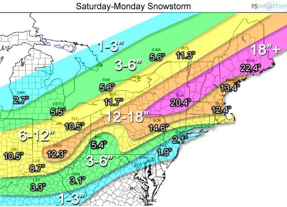
2.1 for the city. Come on we’ll get half that Friday.
-
1 minute ago, allgame830 said:
06z EURO very consistent with 0z maybe even slightly SE... great sign
FYI it really only shows the very beginning of the storm.
Can you post it
-
Pix or it didn’t happen
-
1
-


Winter Begins Jan 20th AWT
in New England
Posted
You guys want to see my snow maps?