Snowcrazed71
-
Posts
3,216 -
Joined
-
Last visited
Content Type
Profiles
Blogs
Forums
American Weather
Media Demo
Store
Gallery
Everything posted by Snowcrazed71
-
I have to laugh at some of the comments. If the models don't show something, the mood is, "we're done nothing's happening". If the models are showing there's a storm happening then the mood is, "this is awesome, let's get one more". I just think several people have winter fatigue at this point. If it happens, it happens. It's been a good winter thus far. Especially after having several years of lackluster Winters
-
Sunday? Is that something new?
-
Well.. the GFS led the way for the blizzard. So I have a bit more confidence in the GFS over the Euro for this upcoming storm
-
Doesn't it kind of seem a little more like the one we had back in January? That one kind of slid up through Tennessee in the states that surround into our area, but wasn't an actual Nor'easter storm. IDK ..
-
I have to laugh, some of my family have been texting me this morning with these ridiculous maps for next Tuesday showing a lot of snow. They're asking me if this is true and freaking out LOL. I told him breathe and wait until the weekend.
-
Let's talk about next Weeks possibility. That one seems like it could be bigger. Other than tomorrow morning...it stays fairly quiet ( with a few milder days thrown in for the weekend )
-
What did you wind up getting? Edit.. saw you reply to Kitz.
-
Bob on WVIT took out anything for Thursday night/ Friday. He said there was some agreement with the medium range models showing everything being pushed out South, but he's not writing it off. That storm next Wednesday looks like it could be another potential snowstorm
-
"Don’t do it" 2026 Blizzard obs, updates and pictures.
Snowcrazed71 replied to Ginx snewx's topic in New England
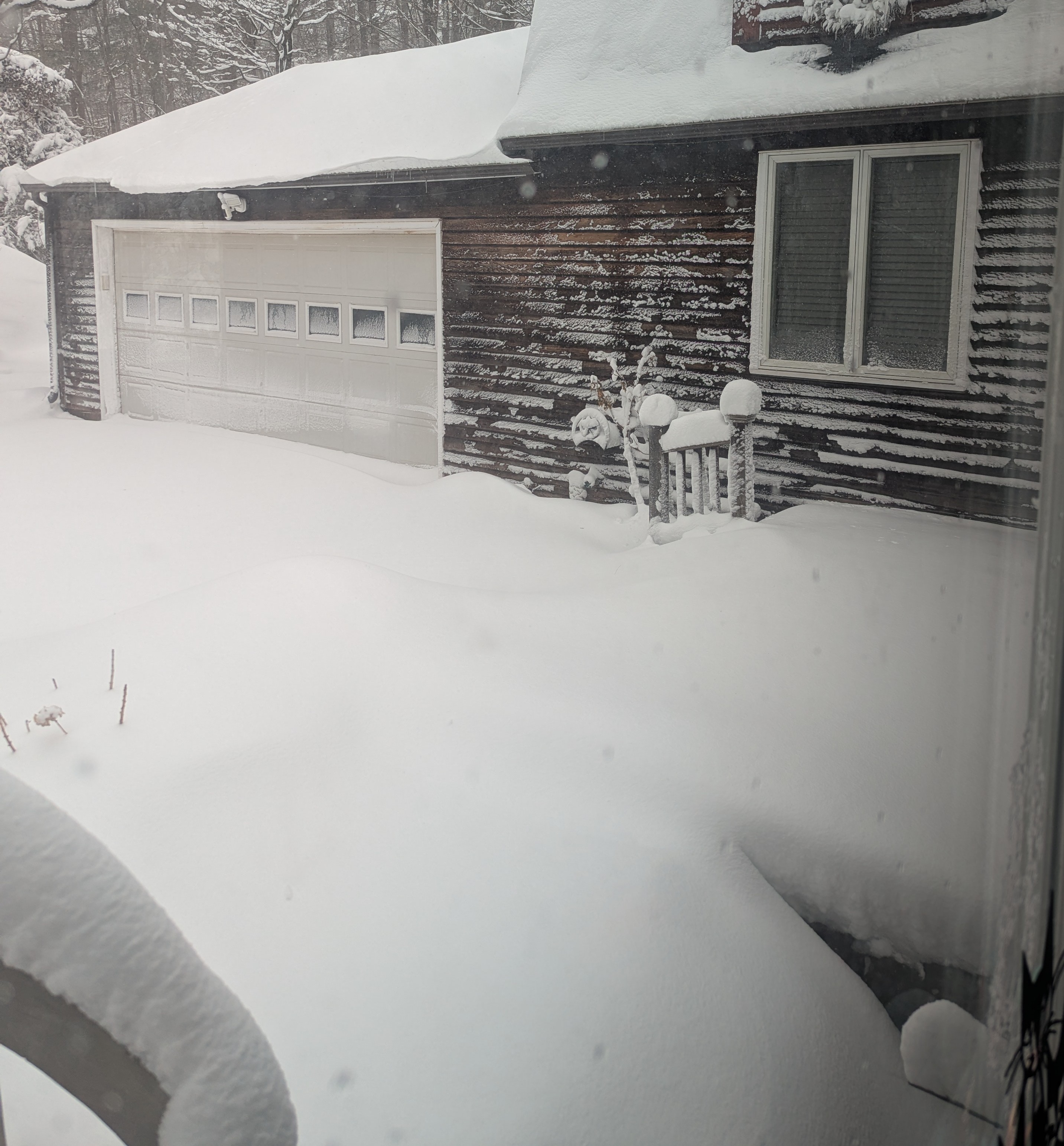
So it was a nice storm. Thought I'd wake up to a bit more, but I think we'll end up about 12 to 13 here. That's about it but nothing to shake a stick at. I know there's a bunch of people out in Massachusetts and Rhode Island that have crushed it, and I know they have been due. Still seems like there's more winter on the table. Enjoy the snowfall
-
"Don’t do it" 2026 Blizzard obs, updates and pictures.
Snowcrazed71 replied to Ginx snewx's topic in New England
So many Debbie downers .. but it looks amazing on radar and also on the satellite imagery. -
“Cory’s in NYC! Let’s HECS!” Feb. 22-24 Disco
Snowcrazed71 replied to TheSnowman's topic in New England
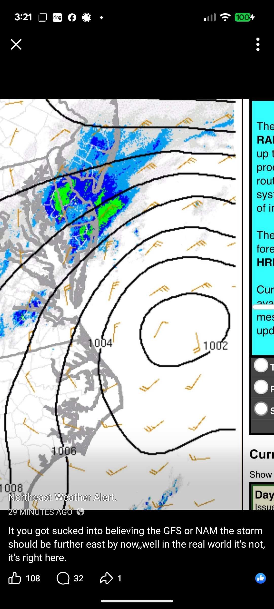
I'll tell you, one thing I like about this guy is he sticks to his guns unless he knows he's wrong. With that said, the low is already west of where the GFS and Nam run from 12z were showing. Things look like they're on track.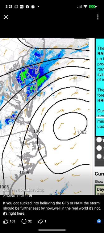
-
"Don’t do it" 2026 Blizzard obs, updates and pictures.
Snowcrazed71 replied to Ginx snewx's topic in New England
Did someone already 06z NAM?!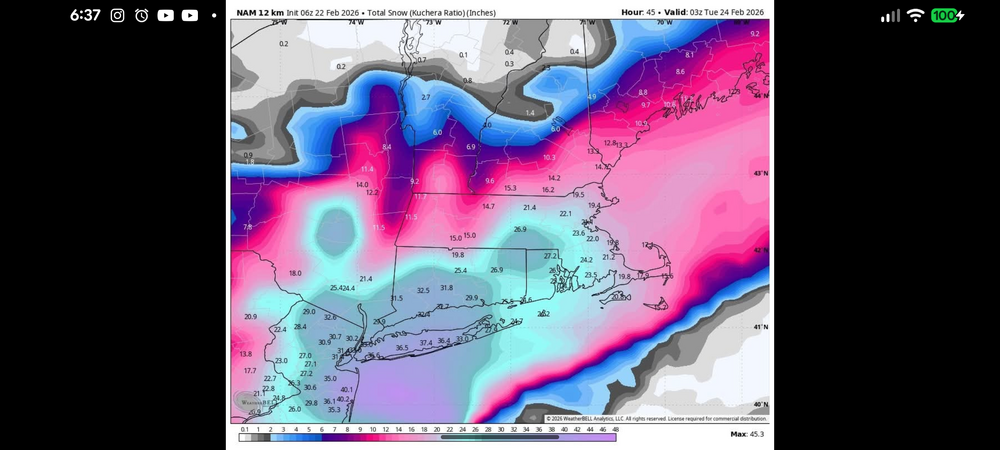
-
Is the one Friday still looking Wintry? I believe the model run yesterday was more rain?
-
“Cory’s in NYC! Let’s HECS!” Feb. 22-24 Disco
Snowcrazed71 replied to TheSnowman's topic in New England
I was looking back on Nemo from 2013 right before the storm got going. The GFS was showing the storm well SE of where it actually was on radar. Point is, when we're getting this close, accuracy on the major models isn't really as important. If I do remember correctly, I was watching Joe fury the night before talking about some the NAM output for snowfall accumulations, and Joe was saying he's not sure he believes what it was projecting. We all know where we ended up in Connecticut. So the Nam snowfall projections wound up coming true.
-
“Cory’s in NYC! Let’s HECS!” Feb. 22-24 Disco
Snowcrazed71 replied to TheSnowman's topic in New England
Since we're within 24 hours of the start of the storm, doesn't it make more sense at this point anyway to use short-range models, not the long-range models like the Euro at GFS? I know the Nam is considered one of the short range models, is this also one of them? -
“Cory’s in NYC! Let’s HECS!” Feb. 22-24 Disco
Snowcrazed71 replied to TheSnowman's topic in New England
Just got the alert on my phone that we're upgraded to a winter storm warning for Northern Connecticut. I wouldn't be surprised if we're upgraded to a blizzard warning even here by tomorrow. This has happened many times before where once the storm gets going, blizzard warnings get extended. Why do I feel like a little right before bed on Christmas Eve..lol -
“Cory’s in NYC! Let’s HECS!” Feb. 22-24 Disco
Snowcrazed71 replied to TheSnowman's topic in New England
Did he post that now for NBC? -
“Cory’s in NYC! Let’s HECS!” Feb. 22-24 Disco
Snowcrazed71 replied to TheSnowman's topic in New England
Most of my family and some of my friends are already done with this. They're all calling me already blaming me for this storm coming. All I could do is laugh. Hysterical. Wouldn't it be ironic if we got another one next weekend...lol -
“Cory’s in NYC! Let’s HECS!” Feb. 22-24 Disco
Snowcrazed71 replied to TheSnowman's topic in New England
Phew! I think at this point we may see fluctuations now with the models but pretty much looks like we're in line for a Whopper. I'm still thinking you could could trend just bit more West. -
“Cory’s in NYC! Let’s HECS!” Feb. 22-24 Disco
Snowcrazed71 replied to TheSnowman's topic in New England
Yeah.. the NWS has us ( you ) with the WSW and is calling for 8-13 inches. There being conservative to say the least. Btw... I saw some of the nerves come out last night with some posts with the 00z runs. Of course everything's looking fine this morning. I'm truly feeling it for this. -
“Cory’s in NYC! Let’s HECS!” Feb. 22-24 Disco
Snowcrazed71 replied to TheSnowman's topic in New England
Which is zero here -
“Cory’s in NYC! Let’s HECS!” Feb. 22-24 Disco
Snowcrazed71 replied to TheSnowman's topic in New England
Well, just like us knowing last night with some of the models showing the storm getting much closer, but most of the media outlets, meteorologist, etc were being very conservative and very careful. They're also being very careful with accumulation amounts for the storm here in Connecticut. I'm just waiting for the NWS in Boston to hoist winter storm watches for the rest of Connecticut and most of Massachusetts. Maybe they're thinking that things will change again and they don't want to put up the watches yet? Or maybe because we're too far from the event ( I would think by tomorrow morning they'll be hoisted ) -
“Cory’s in NYC! Let’s HECS!” Feb. 22-24 Disco
Snowcrazed71 replied to TheSnowman's topic in New England
Give it time.... Things already took many steps in the right direction. Remember, just yesterday this was a " Non-Storm ". -
“Cory’s in NYC! Let’s HECS!” Feb. 22-24 Disco
Snowcrazed71 replied to TheSnowman's topic in New England
Your a dork...lol -
“Cory’s in NYC! Let’s HECS!” Feb. 22-24 Disco
Snowcrazed71 replied to TheSnowman's topic in New England
Wow... The winter storm watches are exploding across the Northeast. Now they have them all the way down into Maryland, Delaware, all of Southeastern, Pennsylvania Southeastern, New York all of Southern Connecticut Rhode Island Southern Mass the islands. I'm feeling pretty confident they'll expand those through Connecticut into the rest of Massachusetts ( maybe not the Berkshires as of ). Maybe by the 4:00 update more of us will be in the watch. Fingers crossed