
jaydreb
-
Posts
2,045 -
Joined
-
Last visited
Content Type
Profiles
Blogs
Forums
American Weather
Media Demo
Store
Gallery
Posts posted by jaydreb
-
-
10 minutes ago, Bob Chill said:
I just posted in the wrong thread again...lol... but it's worth a little disco here. Eps has 40 out of 50 members dropping at least a little snow around the 30th. Only 13 are over 2". 17 out 20 members of the 18z gefs drop at least a little with half of those dropping 2"+.
I know some people don't care about light events but I like every snow event regardless. If we pull off a 2-4" event then this January is actually very good compared to the vast majority. 15-20" in a month in most of our yards with 3 accum events is an A+ month. We all grade on our own metrics but saying this month is a disaster is very unreasonable imho. Statistically it's prob at least 90th percentile of all winter months. I can't think of any Januaries other than 2016 and 95-96 that have been better.
I would take a light event in a heartbeat but are we talking a nice cold snow (like last week’s) or some crap changeover at the tail end of a rainstorm? There’s a difference in how the snow accumulates.
-
Just now, Bob Chill said:
Always keep in mind with ensembles that they are a mean of 20-50 members. Pay more attention to the orientation of the isobars versus where the blues and oranges are. It's perfectly fine for an ensemble mean to show slightly above normal heights but a pretty nice longwave pattern embedded. The only flaw on that panel from a longwave perspective is the above normal heights in far eastern canada. For big storms we want below normal heights there (indicates confluence so storms can't easily cut). Overall though, I'd be fine with that exact longwave pattern from start to finish in any winter.
Thanks for the guidance Bob. Much appreciated.
-
2 minutes ago, Ji said:
i see a ridge in a west and a trough in the east lol. Do you want the oppostite? The ridge is in a good place too
Lol no, I’m still learning how to read these things. I saw the yellow over us and didn’t interpret it as a trough.
-
So how bad is this? I see a ridge out west and oranges over Greenland. But no blues over us. And orange in the 50/50 is not good

-
11 minutes ago, snowmagnet said:
It can only get better from here, right? Don’t answer that.
It doesn’t get any worse than warm wet, cold dry. Literally every other combination is better. Would rather have cold wet, warm dry; cold wet, cold dry; cold dry, warm dry; and cold wet, warm wet.
-
2 minutes ago, LP08 said:
Euro looks awfully similar to tonight and tomorrows rainstorm with a back end snow threat early next week. We have seen those play out all winter.
Really remarkable how every storm recently seems to look the same and take the same track.
-
1 minute ago, PhineasC said:
Is today the best LR look ever or disaster?
We are in disaster mode.
-
Mercifully the GFS appears to be delayed on TT.
-
 2
2
-
-
4 minutes ago, Ji said:
the OP Gfs just refuses to give us snow. They ruined the model....it used to show blizzards during the summer for us
GFS is the new Dr. No. Even the Euro tosses us a bone today.
-
2 minutes ago, nj2va said:
Wow, 18z GFS is a pretty weenie run. Multiple shots at frozen.
I only saw the one.
-
It’s looking less and less likely that this will be an epic or even great winter. That said, many of us (myself included) are at or above climo for this point in the winter and only need another decent event (6” or so) to be able to say that the winter was OK. Take away all the expectations thay we had going into December and I can live with where I’m at.
I totally understand that there are many in the forum who are well below climo and can understand their frustrations.
-
 2
2
-
-
2 minutes ago, MD Snow said:
Things are moving around a ton right now. We won't know anything about a specific threat for next week until the current storm on Thursday gets out of the way. Friday we should start getting some clarity on the Monday-Friday timeframe next week. At this point though, it looks like we have a window of opportunity. That's all you can as for at a 7-10 day lead.
Yep. We are about to enter prime climo so if we’re ever going to get something without a perfect setup now is the time.
-
Euro trolling us. Has two snow events in next 10 days.
-
Euro Kuchera gives us 2” and its only a week away! There is hope.
-
-
15 minutes ago, Ji said:
Just a depressing run
It seemed to have a 6” snow event.
-
Now that’s a storm!

-
2
-
-
37 minutes ago, Ji said:
i have found that long range patterns are often like long range snowstorms...they are seen from afar...they dissapear in the mid range and then all of the sudden...they revert back to what was shown. MJO will be in COD phase 7 by the time Feb rolls around. The last 10 days of January arent idea MJO wise but they are still cold and a chance for snow. Hang in there man! February has been the month everyone is waiting for
Voice of reason?
-
Not a bad look right?

-
Euro has something at the very end of its run. D9-10. Snow all the way down to Florida.
-
GFS way out to sea next Monday unfortunately.
-
3 minutes ago, osfan24 said:
Right, but again, we are talking 15 days out. That's the problem. Nothing is really moving forward in time. And then on the rare occasion that it does, poof, it suddenly disappears.
Pushing the pattern back a week from January 20 was fine. Gives us basically a month and a half of winter to work with. But now we seem like we might be pushing into the first week of February still without a great pattern.
Looks OK, no?

-
1
-
-
Happy January 20th! Let’s get this pattern change going.
-
3
-
1
-
-
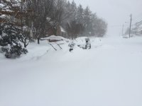
Snow to the North, South, East and West.

-
1
-
1
-


January/February Winter Storm Threat Tracker
in Mid Atlantic
Posted
Wow, some serious cold forecasted for next week on the GFS. Probably won’t verify.