
jaydreb
-
Posts
2,045 -
Joined
-
Last visited
Content Type
Profiles
Blogs
Forums
American Weather
Media Demo
Store
Gallery
Posts posted by jaydreb
-
-
8 minutes ago, NorthArlington101 said:
Hmmm... probably gonna go 1.5” then.
All us N Arlington people should have a meet-up in the summer. Lively company and Backyard BBQ!It’s hard to say whether it’s 1.25, 1.3, 1.5, etc. I know it’s somewhere more than 1” but definitely less than 2”!
-
13 minutes ago, LP08 said:
I live over in Westover and I certainly don’t have an inch. Maybe .75 on the railings.
I live by Minor’s Hill/Williamsburg in Arlington and have a little over an inch. Maybe 1.25” but don’t have a more precise number.
-
 2
2
-
-
35 minutes ago, NorthArlington101 said:
Howdy neighbor. That’s my neighborhood, thanks for the confirmation.
My neighborhood too. We usually do better than the rest of the county.
-
1
-
-
15 minutes ago, NorthArlington101 said:
My family says 1.75” in NW Arlington. Made them check the car and grass. Can anyone else confirm? Seems high, but usually they measure low.

I have about 1”.
-
1 minute ago, nj2va said:
35-40 dbz incoming for DC/Arlington/Alexandria.
Yep, just on the edge of it now.
-
1
-
-
1 minute ago, DDweatherman said:
The back edge has stalled out by Frederick, so for now, we are getting smoked in Westminster. Over 2" now if you include this mornings melted snow.
Smoked in Westminster? I’m shocked!
")
-
1
-
-
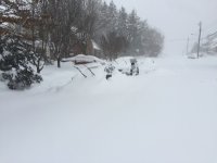
Just huge gorgeous flakes in N. Arlington.
-
Fat flakes in N. Arlington. Side roads caving.
-
6 minutes ago, psuhoffman said:
Now the snowshoe Cheat mtn micro climate puts mine to absolute shame. Sucks it’s so remote and hard to get too. Love snowshoe but when it takes so long to get there I might as well just go up to Vermont. If there was an easier way I’d go way more often.
Yeah it took us about 4 hrs to get here from Arlington but that’s with everything going right- no traffic, no stops, roads clear. I could imagine it being a lot different if the weather didn’t cooperate. The last hour or two were on some windy mountain roads.
-
Well it’s deep winter here in Snowshoe. We came up for the weekend and it snowed pretty much all day today. Light stuff but perfect for skiing. Nice little snow chase.
-
1
-
-
16 minutes ago, MN Transplant said:
NAM changes over at 21z along 95 and has maybe 0.15” fall after that. The snow depth output on IWM is coating-like. This honestly makes the most sense.
It still could be enough to cause mayhem on the roads.
-
6 minutes ago, Maestrobjwa said:
If you wouldn't mind...could you circle where the neg nao is on that panel? I still don't know what it looks like, lol
From the link below: “The NAO consists of a north-south dipole of anomalies, with one center located over Greenland and the other center of opposite sign spanning the central latitudes of the North Atlantic between 35�N and 40�N.“
-
Icon trying to save winter!

-
1
-
-
Icon looks decent for tues-weds. Waiting for precip panels to come out.
-
13 minutes ago, Bob Chill said:
Cmc is a good hit and the gfs dropped 1-2. Icon is in too. Good consensus across all guidance for at least a light event. I like it.
Is the GFS depicting the kind of snow that would actually accumulate? Or snow tv?
-
5 minutes ago, Scraff said:
OMG. What the F is going on here? Sounds exciting! Did @Snowstorm5921 try to breach the digital wall!? Stupid slats design.

We’ve switched out of disaster mode and into HECS mode.
-
 2
2
-
-
17 minutes ago, Bob Chill said:
Once you play this game long enough... like me wasting 13 years of my winter life scrolling through wx models... you come to realize that you actually want the gfs to show the opposite of what you want then apply the wrong bias and extrapolate from there. 18z gfs just said get your shovel ready next week.
Ha. Well hopefully it’s right about this.

-
Let’s bask in the glory of the Euro control because the GFS is a dumpster fire.
EDIT: But redeems itself in the end.
-
Just now, 87storms said:
my hunch is that it'll be more of a squally type situation as opposed to any kind of a storm. temps are somewhat mild leading it, then they drop like a rock. maybe we get into a more wintry pattern thereafter once that pv relaxes. that said, if the euro is showing some decent snow, then i guess that's what we track for now.
Yeah, I mean I would take anything but pouring rain at this point.
-
GFS looks pathetic for Tues-Weds snow.
-
1 minute ago, Ji said:
dude--the euro control is more wrong than the snow crazy ggem. Get your expecations in check
Too late. This train has left the station!
-
Enjoy for 12 hours!

-
2
-
 1
1
-
-
Sad way to honor the 3rd anniversary of 2016.
-
Just now, Ji said:
the GFS lost whatever showmethesnow was hoping would happen
Don’t worry. Still have time to trend towards yet another flooding event.


The Mystical Month of February--Long Range Discussion
in Mid Atlantic
Posted
Yeesh, I hope it’s right because the first 10 days of February (our best climo) looks ugly.