Jump to content

Tallis Rockwell

Members
  • Posts

    133
  • Joined

  • Last visited

Everything posted by Tallis Rockwell

  1. CMC has the best record for picking up on tropical activity this year. 500 mb vorticity shows 3 areas I am interested in. It could just be my overactive imagination but there are 3 patches of vorticity that could Nana, Omar, Paulette(?) The most impressive one is forecast to be a tropical storm, there another less impressive one behind it, and a weak disturbance that moves in the very high potential Caribbean. This over a week after Marco and Laura so I am sure the waters would have recovered. Don't pay too much attention to intensity after CMC has Laura as 980-something low right now!
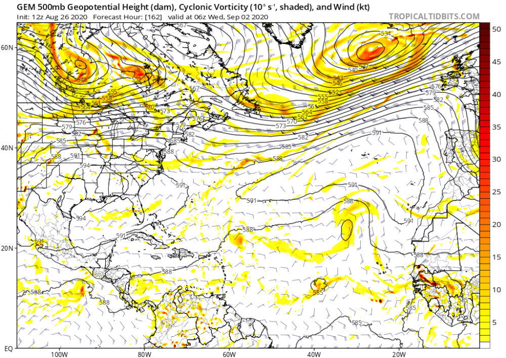
  2. Why does NHC think Marco is going to strength further with the shear? Data from an Air Force Reserve Hurricane Hunter aircraft indicate that maximum sustained winds have increased to near 50 mph (85 km/h) with higher gusts. Additional strengthening is forecast during the next couple of days as the system approaches the Yucatan peninsula, and Marco could be near hurricane strength when it moves over the central Gulf of Mexico Sunday night and early Monday. Is the shear going to move away from the storm? I was under that impression.
  3. Nasty but how will the shear progress?
  4. All that focus on Laura, while Marco might've always been the real threat. How bad is the shear? I didn't see much of it yesterday. (Then again the models have been sh!^.)
  5. That shows potential I guess but land interaction is going to inhibit it. The models, I think, are underestimating it a bit. Not a lot of shear or dry air and some good warm water.
  6. The models are all over the place for both disturbances from major hurricane to literally nothing. Sounds fun.
  7. This coronavirus lifestyle has been my life for almost all of my 20 years so nothing has changed for me this year! I should probably see a therapist though.
  8. Why in the world are so many disparaging this season!? "It's not as intense as 2005 or not a lot of intense systems so far." It hasn't reached the seasonal peak yet! Still ten more days until things actually become favorable for more intense storms. So what if it isn't like 2005? 2017 had fewer hurricanes and lower ACE but was costlier and had a comparable death toll. 2005 should never be the bar minimum for an active season or even hyperactive season. After the largest dust plume in 50 years, sinking air masses, considerable shear, and after factoring out some of the less impressive systems,THE SEASON IS STILL IMPRESSIVE. The models aren't infallible especially this far out and this season's model performance have not been impressive. Sure it's possible that the shear doesn't go down and the dry air continues for the rest of the year but nothing has come to suggest that.
  9. Why in the world is there literally nothing on the models? Usually I would see some fake storms by now but nothing!
  10. Decent weekend ahead. ...Synopsis... A progressive shortwave trough will move from the southern Plains into the lower MS Valley during the day, and will continue to the GA/SC/NC coast by Monday morning. The entire southeastern region will be under the influence of strong westerly winds aloft which will strengthen as the upper trough approaches. Southwesterly 850 mb winds will increase in response to the wave, reaching 50+ kt by 00Z from MS eastward to the coast. At the surface, low pressure will develop near the ArkLaTex by late afternoon as a warm front lifts north across the southeastern states, oriented roughly from southern AR into northern MS, AL, and GA at 18Z. Meanwhile, a cold front/dryline will develop over east TX. Across the warm sector, rich moisture with 65-70 F dewpoints will result in moderate instability. The low, likely associated with widespread convection, will translate eastward along the synoptic front overnight, reaching NC by 12Z Monday. ...Southeastern states... Substantial instability will already be in place Sunday morning from TX into the lower MS Valley, with rapid destabilization expected behind the warm front farther east into GA. Midlevel lapse rates aloft will be modestly steep, averaging 6.5 to 7.0 C/km. Early day storms related to warm advection will be present over AL and GA, and they will likely be elevated with perhaps a hail threat initially. As the air mass warms, a wind or tornado threat could develop in the vicinity of this activity as it continues east. To the west, storms are likely to be severe by 18Z near the Sabine Valley/ArkLaTex. Here, long hodographs but modest low-level SRH may result in cells capable of very large hail, and perhaps an eventual MCS with damaging-wind threat. A severe wind corridor may thus develop during the day across northern MS, AL, and GA. There is also a threat of daytime supercells, possibly tornadic, as the small capping inversion is eroded by early afternoon. During the evening and overnight, low-level shear will increase further, and models suggest southern AL into GA may be a favored area for tornadoes. Bows or isolated supercells are possible into SC early Monday morning as the relatively cooler air mass is destroyed by the warm front.
  11. 18z NAM is showing a more some good helicity over East TX.
  12. Decent stuff this week. Waiting for a watch in central Texas
  13. ...DISCUSSION... An upper trough should impact the western CONUS this upcoming weekend, eventually closing off over parts of the Southwest and adjacent northern Mexico around Day 5/Sunday. Medium-range guidance is in reasonably good agreement that this upper trough/low will eject east-northeastward across the Plains early next week. However, there are still differences regarding the degree of low-level moisture return and resultant instability that will develop ahead of this feature over the Plains and lower/mid MS Valley. Some severe threat may exist from late Day 6/Monday into Day 7/Tuesday, mainly across parts of the southern Plains into the lower MS Valley. This threat could continue into parts of the Southeast on Day 8/Wednesday. Inclusion of 15% severe probabilities in this extended time frame appears imprudent given the differences in both how and when the upper trough/low ejects over the Plains (positive versus negative tilt), and uncertainty regarding the low-level moisture return across these regions.
  14. NAM is really showing something here...Could this be the first high risk of the year? The NAM model are starting to show more discrete cells ahead of the cold front, not a whole lot but a decent bit.
  15. E EDIT: The new outlook has a better picture ...DISCUSSION... The latest runs of the GFS and ECMWF appear to be in reasonable agreement with respect to synoptic-scale features through Day 4 and into the first half of the Day 5 period. After this, differences in the evolution of the large trough progged to crossing the Plains states Day 4 and then the Mississippi Day 5 begin to become fairly substantial. As such, confidence in the predictability of the pattern beyond day 5 is quite limited. In the mean time, some potential for the evolution of scattered to isolated severe storms remains apparent over the eastern Oklahoma and Arklatex region and surrounding areas Day 4 (Sunday 10-20), as a deepening surface low shifts out of the central and northern High Plains and eventually reaches the Minnesota vicinity. Correspondingly, a trailing cold front is shown crossing eastern Kansas/Oklahoma/western Texas during the afternoon, as warm-sector destabilization becomes diurnally maximized. As favorably strong flow aloft overspreads the region in tandem with the advancing surface front, at least isolated cells -- developing as residual capping is locally breached -- will evolve within a sheared environment likely supportive of rotating updrafts. Storms may diminish somewhat in intensity overnight, but it appears that reintensification of convection -- and regeneration of accompanying severe risk -- should occur across portions of the central Gulf Coast region, as the front continues its eastward advance through an amply moist/destabilizing low-level airmass. Again, potential for supercells, and all severe hazards, appears possible. By Day 6, model differences -- including with location of the surface frontal position -- have become substantial enough to preclude continuation of severe risk into the eastern Gulf Coast/southern Atlantic Coast states.
  16. The short range models are starting to agree with 20+ inch totals
×
×
  • Create New...