

Malacka11
-
Posts
2,237 -
Joined
-
Last visited
Content Type
Profiles
Blogs
Forums
American Weather
Media Demo
Store
Gallery
Posts posted by Malacka11
-
-
5 hours ago, Stebo said:
Yeah I think we are going to be gradually warm after this next 5 days. Back half of the month is already starting to show some eastern ridging on longer range models. The light at the end of the tunnel is quickly approaching.
Good, because this shit is ass.
-
 3
3
-
-
This weather is so nice it's not even on the shelf in the first place
-
1
-
-
5 hours ago, StormChaser4Life said:
The headlights across from you are me and my chase partner. I didn't even see a car across from us get impacted. I'm glad you're okay man. Could have been way worse.
Wow, small world dude. Kind of cool to think about though.
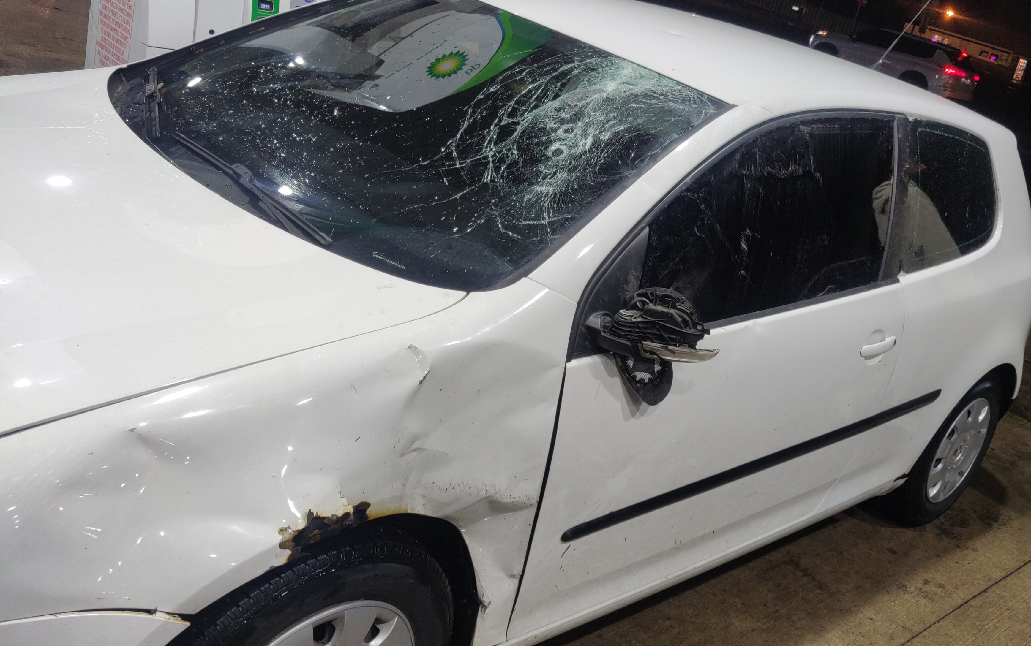
So far I've replaced my windshield and my mirror. The mirror I managed to do myself relatively easily. That leaves the the quarter glass which I've ordered online and will need someone to install and then eventually a new fender. For now I just took a crowbar and pried the fender back out far enough so that it lets the driver's door travel freely again. Considering the fender was already rusted to shit and I was looking at replacing it this summer anyway, I hardly count that as a loss. Really, I'm just glad that I was able to drive the car home because the cost of a tow (my insurance plan does cover most towing costs but idk about a 200+ mile job, I ought to check up on that) and a lift for my friends and I would easily have cost more than all of the repairs I've had to do. Between that and the fact that I didn't die + now have a one in a million story to tell isn't a horrible deal I suppose. Obviously I would never ever want this to happen again but the fact that it did and I got off easy in the grand scheme of things is definitely something I am thankful for.
Cheers though. Hopefully our paths cross again in the future.
-
2
-
-
10 minutes ago, WaryWarren said:
Don't beat yourself up too much, Malacka. Just look at this guy.
Damn. That's really fucked.
-
Couple of updates regarding the other day's chase:
1. The tornado that hit us was an EF1, max winds of ~110mph. The messed up part is that it formed less than a mile before it hit us and dissipated less than a mile after. That fucker JDAM-missile style tracked us down. Makes me feel a bit better about being hit that we can't have possibly seen it given that it formed only after we were between houses and only a few hundred meters away.
2. There was a much larger EF3 with max winds of ~160mph forming right behind the wall of wind driven rain that we thought was the tornado.
All in all, these new revelations make me feel a little less incompetent. Yes I fucked up, but in the heat of the moment, we probably did as well as we could with the cards we were dealt.
Here's the link to one more video, showing exactly what we were running from and why it was impossible to actually see what was going on. https://youtube.com/shorts/7pvTvyIsgzE?feature=share
-
1
-
-
4 hours ago, Chicago Storm said:
welcome to the 0 meter club.
Thanks hoss.
-
37 minutes ago, Stebo said:
Jesus man, I am glad you are fine, I would definitely be more careful next time though.
Trust me homie I can't stop thinking about how badly we fucked up. The message was especially driven home by the smashed houses we drove past afterwards. I dont know when I'm gonna chase again but I will seriously reevaluate my approach when I do. We really weren't trying to get close, it's just that as the cell became tornadic it seemed as if the mesocyclone veered straight west towards us.
We got to the storm just as it was entering the "capable of producing a tornado" verbiage phase of its warning. After about two minutes of standing and watching the beautiful supercell structure, we realized that the base of the storm was starting to race towards us and a second later we noticed that every single pro chaser was barreling down the road towards us straight away from the storm (talking trucks with sensors and warning lights). Of course we jumped in and started tailing then but it turns out they had no idea what they were doing either. At some point they made a left and then we all ended up doing a three point turn on this tiny ass farm road to double back. Only at the very last second did they save themselves by turning left where we turned right in the town. We realized our error and made a u-turn and that's when we got hit.
-
2
-
-
22 minutes ago, Stebo said:
Bruh that was way too close.
You saw the other video right? The other chaser's POV? The headlights in the distance was us.
We just got screwed because we thought the tornado was far wider than it was and let ourselves get forced into a town.
Thought we were running from a wall and then ended up getting directly hit by a skinny drill bit.
-
3
-
-
Here are two videos from yesterday. First one is of the supercell itself and the second is from inside the tornado. I'd like to apologize in advance for not only using phones, but also recording in vertical format. Didn't have time to pull the DSLR out unfortunately for good shots of the storm, and obviously I'm just happy to have any footage from inside the tornado at all.
Oh yeah, and please excuse my language in the second video. Hard to stay PG when you think you're about to get maimed. Looking back I didn't even duck down, idk what I was thinking.
https://youtube.com/shorts/d5M407cuge4?
feature=sharehttps://youtube.com/shorts/fRWcBVP-nUA?feature=share
Again, apologies for the excessively amateur impression I'm making here.
-
9
-
-
The headlights on the left side of the road in the distance is my car. Turns out it wasn't a wide tornado like I thought, it was actually a little shit at that point and I'm even dumber than I initially figured.
-
1
-
 3
3
-
-
Got stuck in the outside of the tornado. It was a rain wrapped beast the size of a field. We ended up trapped in a small town. A trashcan went airborne and hit us. We missed the trampoline by a couple yards at least.
I am truly thankful to have survived. Judging by the EMTs everywhere and the couple of destroyed houses we came across miles later, I probably shouldn't have. I fucked up so badly today that it's hard to actually comprehend the magnitude of it. I know I'm the amateur of amateurs amongst you all but even I knew better than to do what I did today.

-
3
-
 14
14
-
-
2 minutes ago, WaryWarren said:
Hawkeye'd.
Ryan Hall just mentioned Malacka, not by name.
Oh?
-
I just got stuck in the Nader lost two windows and a mirror
-
1
-
4
-
-
Opting to chase the Beardstown storm for now since it's more discrete. Nice CGs from it right ahead.
-
In Iowa now. Just gonna have to wait and see.
-
3
-
-
6 minutes ago, andyhb said:
Got a couple of cells going up SE of Kansas City. Lead shortwave appears to be impinging on the warm sector.
In terms of actual impact what would this mean?
-
12 minutes ago, DaveNay said:

Best I can do right now
-
2
-
-
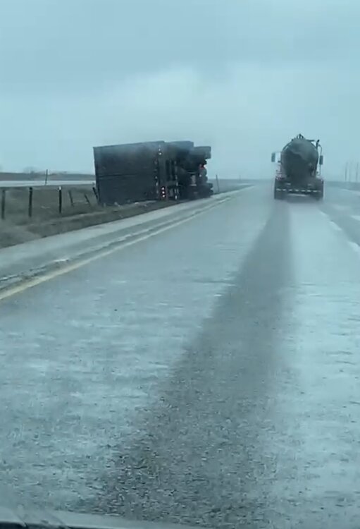
Up to five flipped semis now
-
4
-
-
3 minutes ago, A-L-E-K said:
always nice too see board member out having fun
Appreciate you big guy, hopefully I manage to find something worth posting
-
1
-
-
Dude that cell near Rochelle was legit as it passed overhead. The greenest clouds I've ever seen, the whole sky was one writhing mass. One semi almost tipped over right in front of us, a mile down the road one was on its side.
-
5
-
-
Tipped semis on 88
-
1
-
1
-
-
Just hitting the road, the "first Tuesday of the month" siren just deafened us from right across the road. Foreshadowing much?
-
1 minute ago, brianc33710 said:
So for Day 1 do we have 2 MODS, 1 big MOD, 1 HIGH & 1 MOD, or 2 HIGHS? I'll go with 2 MODS but will fully admit I thought the SPC HIGHS were an overreaction Friday. I wish I had been right.
I'll go with two mods too
-
1
-
-
The RRFS looks a whole lot better too. Still west but with a whole squad of beefy discrete cells.

2023 Short/Medium Range Severe Weather Discussion
in Lakes/Ohio Valley
Posted
This has got to be one of the funnier warning areas I've seen so far. Unfortunately I am about to drive directly through it from east to west.