

Malacka11
-
Posts
2,068 -
Joined
-
Last visited
Content Type
Profiles
Blogs
Forums
American Weather
Media Demo
Store
Gallery
Posts posted by Malacka11
-
-
Blizzard warning for Dupage.
-
3 minutes ago, Hoosier said:
ORD just gets piledriven on the 6z HRRR...if only it were a degree or two colder.
Piledriven... cause they'll be shoveling... piles
")
-
Just now, CoalCityWxMan said:
Not to mention widespread wind gusts of 45-55MPH...quite the blizzard being depicted here.
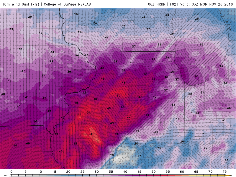
It'd be nice to wake up to blizzard warnings. This all still seems surreal. I remember up until a week ago, I was hoping we'd get something like this in January or February not in five days.
-
1 minute ago, Hoosier said:
Anybody still watching the Euro?


Come to Papa
-
Ehh, seeing that everything is shifting North again, I'll shift back to being satisfied with 3 inches in Aurora. Enough to make the ground white.
-
Just now, Thundersnow12 said:
It's not. It's the 3km NAM (Nest)
My bad lol
-
2 minutes ago, Thundersnow12 said:
NAM and more so the Nest are an absolute train wreck across the Chicago metro area, as well as being slower.
Cut off on the SE side ends up being further NW, and the NAM has a 10" spread from GYY to extreme northwest Cook
Off topic but why is the 6k NAM called the NAM NEST?
-

This is a map I like (posting it just for fun)
-
 1
1
-
-
Personally, I know I was all about not getting my hopes up early but it's really hard not to. Sitting here in southern Dupage with at least six inches of snow would be pretty cool, and that's if the more northern solutions come to fruition. All it takes is a small bump South to get a nice bonus (if the insanity the models depict in north central IL is even possible).
-
 2
2
-
-
12z NAM12k:

18z NAM12k:

Again, I'm a total amateur, but the one thing that sticks out to me is that storm depicted in 18z is somewhat stronger... bottoms out at like 995 millibars rather than 998 or whatever.
-
Definitely north...
-
2 minutes ago, hawkeye_wx said:
For my area, this is one of those classic "in the bulls-eye three days out is bad" systems. It should be fun for Chicago.
Let's see what the 18z NAM has to say on the matter.
-
1 minute ago, IllinoisWedges said:
Looks like LOT hoisted winter storm warnings for more of the CWA.
Don't think I've ever heard of a 4-10 inch spread before. It's lookin up boys
-
Just now, Hoosier said:
At peak? 1-2" per hour, maybe even 3"
Damn. I'll bite!
-
Just now, Hoosier said:
Great point. I usually prefer looking at it more than a 10:1 map since it at least tries to account for different ratios, but only when you know you're going to be all snow. Also have to consider things like ground temp, etc that the Kuchera map doesn't know about but in this case the rates should overcome that fairly quickly.
Speaking of which, what type of rates are we looking at? I've seen many different things mentioned in different places thus far
-
Looking at all these crazy totals and all... I'll settle for 3". That'd still be the most we've gotten all season and it'll be all white outside. Don't wanna overhype to early.
-
4 minutes ago, SchaumburgStormer said:
That is the old one.
That seems more realistic at this point.
-
Just now, cyclone77 said:
That was one hell of a run lol. A little less out this way at "only" a foot, but I guess we'll just have to settle for that.

If only.........
-
 1
1
-
-
To my layman's perspective, it seems that all of the short-range models are similar (in the placement of the low at least) to the NAM. Dunno if it's worth pointing out or not.
-
00z GFS out an rolling. And so it begins...
-
Someone needs to turn the SE Michigan snow magnet back on...
-
1
-
-
Just now, SchaumburgStormer said:
Eh. Maybe a touch, but it looks pretty close to the 12z so far
In placement of the low that is (or so it seemed to me early on)
-
NAM looks farther north too right now
-
2 minutes ago, Stebo said:
Lock in the 00z Euro

Not to be needy, but could you send another image? Share the beauty

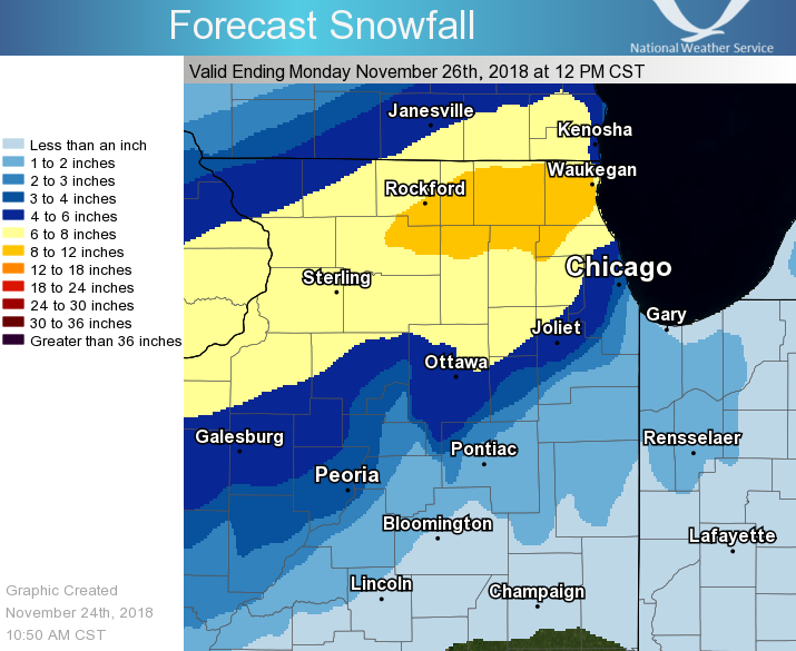
Nov. 25th-26th Midwest Snowstorm Potential
in Lakes/Ohio Valley
Posted
Extremely light rain/mist here in my part of Aurora.