

Malacka11
-
Posts
2,068 -
Joined
-
Last visited
Content Type
Profiles
Blogs
Forums
American Weather
Media Demo
Store
Gallery
Posts posted by Malacka11
-
-
I know a lot of people don't like the ICON on this forum (or that's the impression I've gotten at least) but it's been pretty consistent so far with a northern track... until now, where it shifts as far south as the NAM did or further.
-
9 minutes ago, Hoosier said:
It's fine to look. Now at what point is it worth talking about seriously is another matter.

Fair enough
")
-
At what point do the NAMs become worthy of a glance?
-
Just now, Hoosier said:
12z Euro is a crush job in the heavy band. And big nw to se gradient around Chicago metro.
Be still, my heart. Do you have a pic by any chance?
-
-
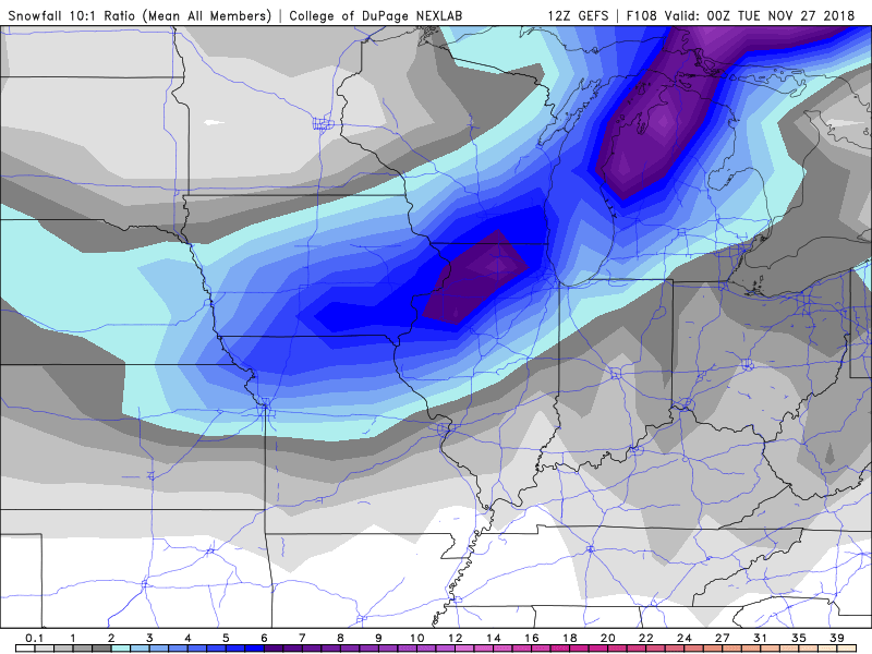
The GEFS sums up the change in the GFS's depiction of the event nicely. Farther south, but slightly weaker.
00Z:

18Z:

-
18z GFS is quite similar to its 12z counterpart
-
29 minutes ago, Baum said:
Rumour has it 12Z GFS is further south and east with the Sun-Mon threat.
Sent from my SM-G960U using Tapatalk
And much weaker with the 6z / 12z runs
-
8 minutes ago, Stebo said:
Yeah, everyone buy rock salt and snow shovels, it is about to get real deep
*It's the most wonderful time, of the year*
-
 1
1
-
-
Indeed. Somebody said a week or two ago that they had a lot of faith in this being the predominant track of the winter, and so far they're right.
-
1 minute ago, michsnowfreak said:
I remember quite a few storms that covered a ton of ground. Not those ridiculous totals, but good storms.
Huh. Yeah, if you discount those 24+ inch values, the would-be storm becomes a lot more believable.
-
What's the latest on the Monday-ish time frame? Haven't had time to check the models or anything yet today.
-
21 minutes ago, RogueWaves said:
And most of S Michigan went to Bliz warned after this.

Absolute U N I T of a storm. It's strange to imagine that the locally crazy snow totals may not have even been the most impressive thing about GHD I.
-
2
-
-
3 minutes ago, RogueWaves said:
Don't have a precip map handy, but I'm almost certain GHD1 covered even more (in the CONUS vs Canada I mean).
Wow...
-
46 minutes ago, snowlover2 said:
This is our usual thread for storm threats in the longer range that are not ready for its own thread.
There appears to be a system for next Monday/Tuesday that will move along the south and then up the apps/east coast. 12z Euro has precip the farthest north/west to bring some snow to IN/OH.
The ICON agrees, though it takes the system further west

-
40 minutes ago, snowlover2 said:
This is our usual thread for storm threats in the longer range that are not ready for its own thread.
There appears to be a system for next Monday/Tuesday that will move along the south and then up the apps/east coast. 12z Euro has precip the farthest north/west to bring some snow to IN/OH.
I hear you and raise you this hilarious CMC output from last night:

Obviously this was just some laughable model fluff (if only it weren't), but simply out of curiosity, has such a widespread event ever occurred in the history of this country?
-
1
-
-
3 minutes ago, CoalCityWxMan said:
Things looking up for sure. Don’t remember seeing this wintry of a look in early November in a very long time
Honestly. It feels like we just resumed February of last year or something.
-
18z gfs is once again slightly more organized than previous runs regarding Thursday-Friday... At least it seems like it to the naked eye. It's definitely not-black and-white map like it was a few days ago...
-
4 minutes ago, CoalCityWxMan said:
Both the GFS and GEM agree on a clipper type system coming through the region Friday-Saturday, certainly not the big storm modeled a few days ago but could bring some snow if it happens nevertheless.
It's still snow in November
-
 1
1
-
-
22 minutes ago, Snowstorms said:
The GEFS, an ensemble model, basically takes the data from the GFS (it's numerical weather model counterpart) and looks at the different uncertainties that can exist in actual weather observations. The GEFS corrects this uncertainty through its multiple ensemble forecasts during each model run (0z, 6z, 12z and 18z) and looks at the different scenarios that could play out from a single forecast. Despite trying to reduce the uncertainty, especially in the medium-long range, there still exists some spread between each run, hence any forecast beyond a certain point should be taken with caution (spread-skill relationship). As well, this spread is actually quite noticeable when you look at spaghetti plots.
This is all I know.
Thank you very much
-
1
-
-
Just now, Hoosier said:
A model expert could give a more technical answer, but basically, it's taking the GFS and perturbing it in a bunch of different ways to give a variety of solutions. Naturally, the spread in the individual GEFS members will tend to narrow at closer time ranges.
Thanks a bunch chief, that's what I thought it was, I was just confused about whether the GFS is the original model with no altered parameters or if it's just one of the GEFS ensemble members. Thank you for clarifying
-
34 minutes ago, Hoosier said:
FV3 brought back a little something. Passes to our south though.
I feel strangely optimistic about getting some snow out of this, even with the model disagreement.
I concur. I have a question, perhaps you can answer it: What's the relationship/correlation between the GFS and GEFS? I know this is a very basic question, but I've been wanting to ask it for a while because I feel like I'm missing something.
-
9 minutes ago, Hoosier said:
Kinda took a step back since last night, lol

It do be like that sometimes...
-
7 minutes ago, Hoosier said:
Anything even close to this would be pretty wild before the midpoint of November.

Agreed. Tonight's model runs will be exciting...
-
1
-


Nov. 25th-26th Midwest Snowstorm Potential
in Lakes/Ohio Valley
Posted
TWC with that rapid change from less than an inch of snow to 5-8 inches. As long as the weakening trend doesn't continue... It'd be funny if they'd have to change it again lol