

Jrlg1181
-
Posts
290 -
Joined
-
Last visited
Content Type
Profiles
Blogs
Forums
American Weather
Media Demo
Store
Gallery
Posts posted by Jrlg1181
-
-
Drought warning issued for Augusta County , was wondering when that was coming.... Most places picked up at least a inch over the past 5 days- But outside of a few spots that are lucky with tstorms - widespread rain has been nonexistent since the end of June.. Now another prolonged period of dry weather coming up...
-
0.75 yesterday , a 3 day total of 1.20. Much needed , everything outside just seems a bit more refreshed and a touch greener this morning in the sunlight..
-
 3
3
-
-
Finally, finally , FINALLY ... A nice long band of rain over my area has been in place for about a hour , nothing extreme but it's over 0.60 so far today.....

-
2
-
-
The ultimate challenge, can we we get some real rain out of this setup ? Rain completely around me ....

-
Picked up 0.07 earlier today , looks to be about it down here , for a 3 day total of 0.45 .... The biggest rainfall event here since July 18 - 19 when 0.40 fell...
-
1 hour ago, EastCoast NPZ said:
This is 100X better than anything I've seen this year. Still going.
Well dam , I guess I am now the epicenter of the drought.... 1.29 since July 20th.... lol.
 ...... Seriously though - glad you finally some solid rainfall !
-
7 minutes ago, EastCoast NPZ said:
I see the dry pocket has already formed for the shenandoah desert. Perfect U with rain west, south, and east. And we managed to bake all day in 90F sun on top of that.
You ain't joking, that U shape has happened nearly everytime.... Even nws can't get it right, today was the first flood watch of the calender year down here, but the rain has obviously set up everywhere but the valley...
-
1
-
-
Wow , simply amazing , it actually rained a bit .... 0.08 the last 5 weeks... 0.37 today !!!!
-
2
-
-
17 minutes ago, EastCoast NPZ said:
You can't make this shit up.
That's usually my kind of results downhere....
-
57 minutes ago, Jrlg1181 said:
Impressive no thunder lightning display off to my south right now... Almost nonstop lightning in the taller cloud tops that i can see from storms that are firing in the Lynchburg to Nelson county area... Can we break a now 5 week streak of only 0.08 here ? Probably not ...
And as expected - never had a shot, a chance or a glimmer of hope ...
-
 1
1
-
-
Impressive no thunder lightning display off to my south right now... Almost nonstop lightning in the taller cloud tops that i can see from storms that are firing in the Lynchburg to Nelson county area... Can we break a now 5 week streak of only 0.08 here ? Probably not ...
-
The last 28 days here I have measured a amazing 0.08 , Going back to July 20th roughly 45 or so days I have picked up 0.92 - Simply incredible...
-
1
-
1
-
-
2 hours ago, Jrlg1181 said:
Cluster of showers developing in the southern valley where it's been alot wetter heading this way, will they make it ? Or will they fade just before they get here or just magically jump east for some reason toward hooville ?
")
As expected the gradual move toward charlottesville occurred, finished a supposedly wet 3 day period with a final total of 0.03... 0.56 final August total.. For whatever reason - right now it does indeed appear that the northern half of the Valley simply can not recieve much or any precipitation....
-
1
-
-
Cluster of showers developing in the southern valley where it's been alot wetter heading this way, will they make it ? Or will they fade just before they get here or just magically jump east for some reason toward hooville ?
-
4 hours ago, EastCoast NPZ said:
W nor NW flow obviously will do it. SW cannot do it. S flow can't get it done anymore. And now E flow can barely generate a cloud, much less a drop of rain.
Picked up another 0.01 this evening - raises my monthly total to 0.56 Meanwhile the last 36 hours has seen heavy heavy rain and numerous warnings to our east , south , west , and northwest.. Almost like the letter U... With most of the Valley from northern Waynesboro up to Winchester being a desert in the middle of a rainforest...
-
1
-
-
56 minutes ago, stormy said:
24 hrs. later I have received 5 drops instead of 5 inches.
This is not 15 day low resolution wish-casting from the GFS. This is 24 hr. high resolution from the NAM 3k.
The GFS and ECMWF regularly average 8 - 15 degrees inflated with heat at 24 hrs... Now the NAM 3k misses by 5 inches with 24 hr. rainfall.
I believe Gordon Barnes could have done better with his primitive tools in 1975!!!
Do we continue to delude ourselves with 21st century high tech??
I saw your post then looked at the NAMs last night...I was thinking without a tropical or some cutoff low again my backyard may not see another 5 inches of total precip the rest of the year.. but I guess the model did get the totals right just 100 miles to our south and east
-
1
-
-
Wow nearly a foot of rain south of Roanoke this morning unfortunately, some 3 inch totals in and around Charlottesville yesterday, and here well we wait...
-
This certainly does appear to already be a cane, would be a shock if it's not upgraded at the next update... Interested to see what the incoming recon data shows.
-
And the Charlottesville & eastern Albemarle soaking continues...I know the Rivanna River in Charlottesville has been super low, but it's not from the lack of rain within the city, it's from the lack of rain in it's headwaters...
-
1
-
-
3 hours ago, Jrlg1181 said:
Missed a nice shower by about 400 yards , so my little spot in nw Boro remains at a 2 month total of 3.26... Dry ain't the right word anymore.. Shower developed just to my west and drifted SE...

And just missed a 2nd time this evening about 400 yards again to my east, it just won't rain here...picked up .02
-
1
-
-
Missed a nice shower by about 400 yards , so my little spot in nw Boro remains at a 2 month total of 3.26... Dry ain't the right word anymore.. Shower developed just to my west and drifted SE...
-
1
-
-
1 hour ago, MN Transplant said:
Nice 0.74" to break a short dry spell of just over a week.
0.00 here to not break this year's 2nd drought which began first of July... 3.26 total in almost 2 full months of summer with only .53 this month...Still waiting to hit the 20.00 inch mark for the year...

-
1
-
-
On 8/15/2023 at 2:48 PM, Jrlg1181 said:
Now over the last 3 days the dryness has really began to show in nearby lawns and small gardens down here... Only 0.89 of precip in my backyard since July 20th... Hottest period of summer has turned out to be the driest period of a overall super dry year...
-
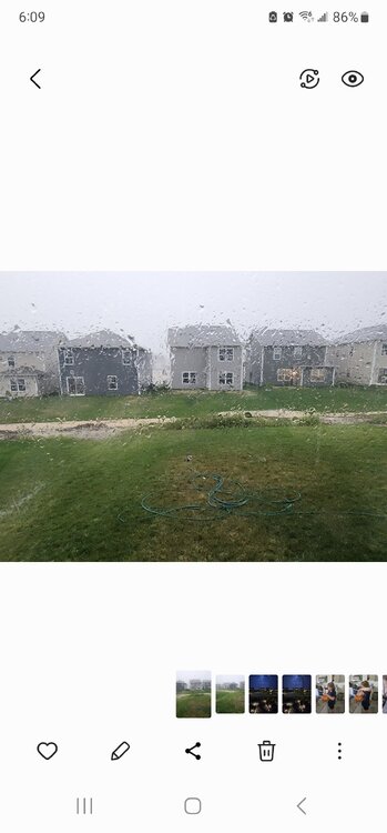
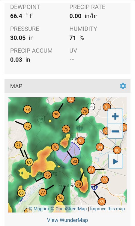
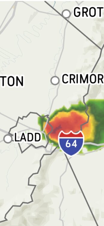
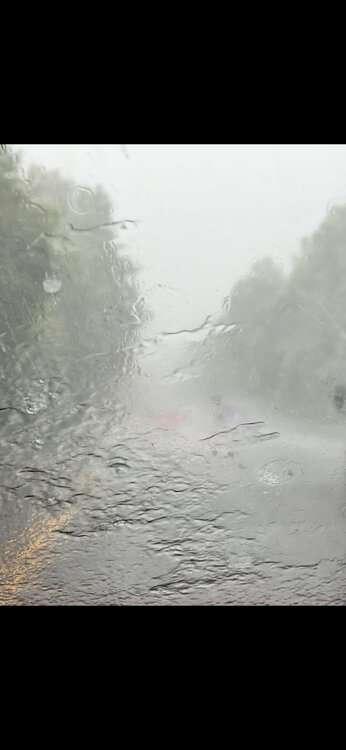
Just now, Jrlg1181 said:
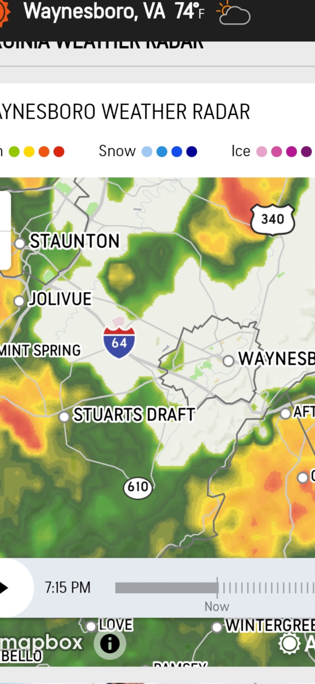
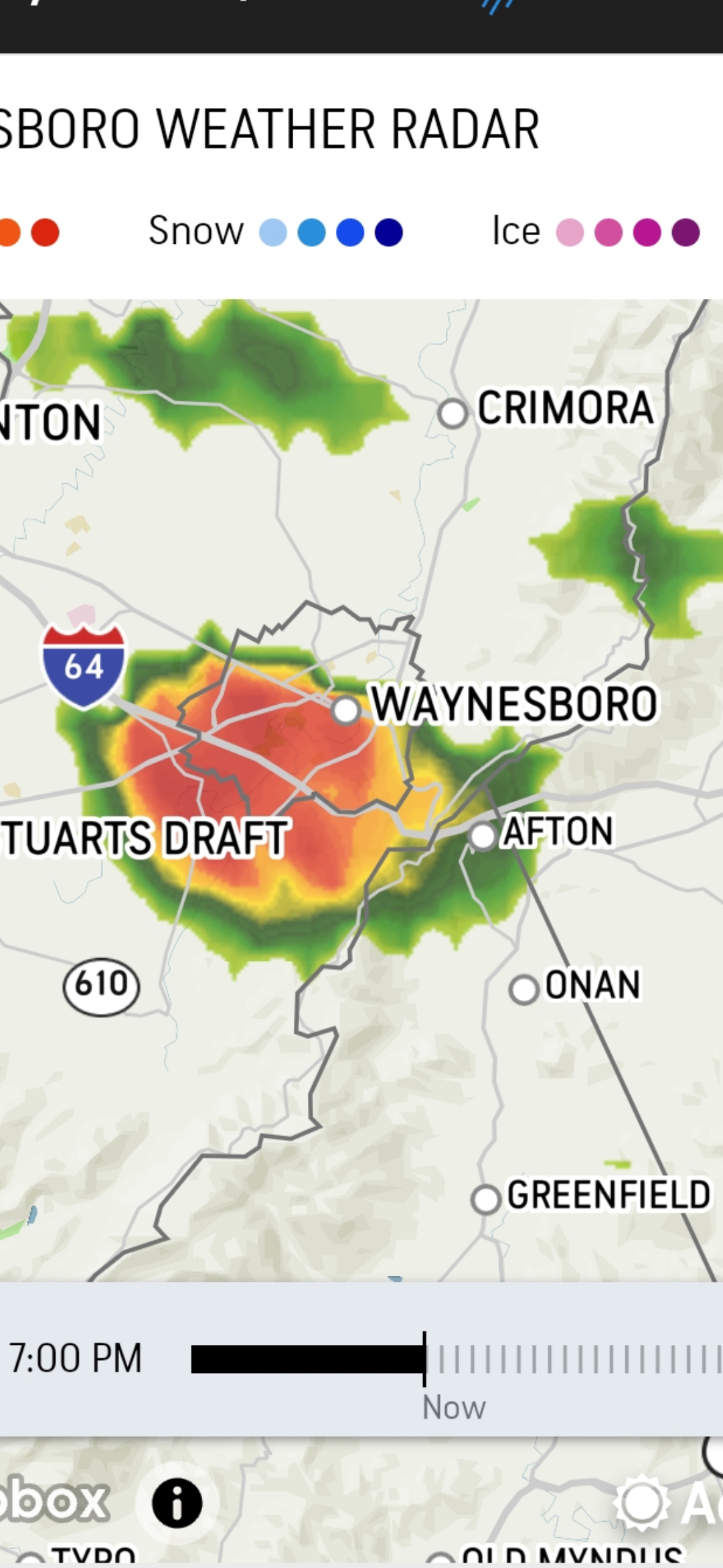
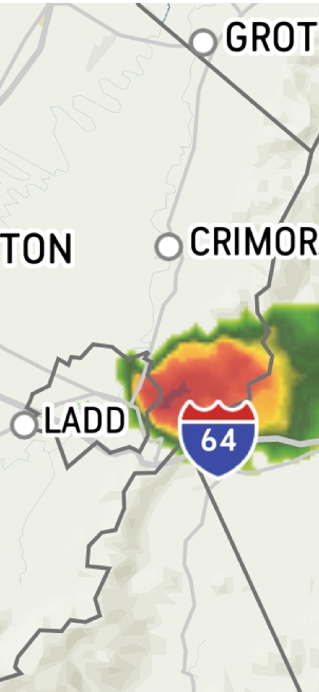
Meanwhile about 15 minutes to my east along i64 headed to work in charlottesville as expected its a blinding downpour easily a inch plus...same places over and over..
-
2
-


September Discobs 2023
in Mid Atlantic
Posted
0.03