
Holston_River_Rambler
-
Posts
5,107 -
Joined
-
Last visited
Content Type
Profiles
Blogs
Forums
American Weather
Media Demo
Store
Gallery
Everything posted by Holston_River_Rambler
-

Fall/Winter Banter - Football, Basketball, Snowball?
Holston_River_Rambler replied to John1122's topic in Tennessee Valley
6z GEFS member 6 has some potential: -
February 2024 mid/ long range
Holston_River_Rambler replied to Holston_River_Rambler's topic in Tennessee Valley
The strat has done that with every attempted warming this winter. Sad. I have to admit @Carvers Gap I'm losing heart. Crocuses and daffodils now spring where the elk once trod. Trees are budding out on top of little Brushy mt. The MJO avoids the western hemisphere like Dale Farmer avoids Boozy Creek. I told myself after the "el nino" tongue-in-cheek comment I needed some time off until the weekend, but I can't not check on Americanwx yet. Too early. But even today's February bowling balls hate us and want us to die : I think we even have some sort of a pseudo Norlun trough over the Carolinas aimed at Damascus VA- 750 replies
-
- 7
-

-

-
- snow elk
- wooly worm
- (and 1 more)
-
February 2024 mid/ long range
Holston_River_Rambler replied to Holston_River_Rambler's topic in Tennessee Valley
El Nino- 750 replies
-
- 1
-
-
- snow elk
- wooly worm
- (and 1 more)
-
February 2024 mid/ long range
Holston_River_Rambler replied to Holston_River_Rambler's topic in Tennessee Valley
Got an NAO that looks like the strat one from 2018 at the end of the 6z GFS. I guess we'll see if it can hold.- 750 replies
-
- 2
-
-
- snow elk
- wooly worm
- (and 1 more)
-
February 2024 mid/ long range
Holston_River_Rambler replied to Holston_River_Rambler's topic in Tennessee Valley
Most people I see talking about it seem to think the hurricane season this year will be bonkers. I think I saw some reports of current heat in the Atlantic = to what we normally see in July. Supposedly high ACE seasons can correlate to better winters in the east. Raindance is already worried about + temp anomalies in the southwest.- 750 replies
-
- 1
-
-
- snow elk
- wooly worm
- (and 1 more)
-
Winter 23-24' Wx Observations Thread
Holston_River_Rambler replied to Carvers Gap's topic in Tennessee Valley
Split window difference really cool this morning: Nighttime microphysics on the same-ish sector: I think the green on the split window denotes higher dewpoints, so it is really interesting to me that it is right at the edge of the clearing over KY. -
Winter 23-24' Wx Observations Thread
Holston_River_Rambler replied to Carvers Gap's topic in Tennessee Valley
Alright Kingsport folks, here we go. I think the wind is orthogonal to Bays Mt right now. The band seems to show up when it is more WNW. It does seem to be turning. I expect that band to show up at some point. I took some pics in Kingsport yesterday to see th sides of Bays mt. better and may try to puzzle on the band again this afternoon. I'm even thinking about just a specific random thread trying to figure out more about how topography impacts weather in east TN if I have time. -
Winter 23-24' Wx Observations Thread
Holston_River_Rambler replied to Carvers Gap's topic in Tennessee Valley
Also WOOOHOOOO I tied Knoxtron for once. -
Winter 23-24' Wx Observations Thread
Holston_River_Rambler replied to Carvers Gap's topic in Tennessee Valley
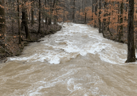
Welp, I too was surprised with a dusting this morning on elevated surfaces. Saw flurries when I let the dogs out at 230 AM. Can't believe it was almost 70 a few days ago. I mean, I can see a big storm overcoming warmth in front of it, but this little one did too. -
February 2024 mid/ long range
Holston_River_Rambler replied to Holston_River_Rambler's topic in Tennessee Valley
With regards to the stratosphere stuff here is a trip down memory lane from 2018, when we had a SSW at almost the same time in Feb. (Feb 11) Different ENSO state, but if anyone wanted to look at some maps from that SSW, I found some cruising around our posts and other subforum posts from Feb 2018. MJO from that winter: Some similarities to what we have seen this winter. 2017-18 was a weak-moderate Nina. Probably a west pac warm pool/ PDO thing. H5 heights and height tendencies around the third week of Feb 2018. It's an unusual metric, but finding images from 2018 that are still active on Americanwx ain't easy lol: All of Feb 2018 monthly H5 anomaly composite: Here is what the Euro weeklies started to spit out around Feb 19 for early March: There is some weaker blocking showing up on the Euro extended control for this March but not until mid-late March:- 750 replies
-
- 6
-
-

-
- snow elk
- wooly worm
- (and 1 more)
-
February 2024 mid/ long range
Holston_River_Rambler replied to Holston_River_Rambler's topic in Tennessee Valley
Remember when the GFS was the most SE of models for tonight in to Saturday AM? The elk remembers: But it was almost 70 in places in east TN yesterday, so not too surprising.- 750 replies
-
- 4
-
-
-
- snow elk
- wooly worm
- (and 1 more)
-
February 2024 mid/ long range
Holston_River_Rambler replied to Holston_River_Rambler's topic in Tennessee Valley
Based on what jax posted, it sounds like the pros are expecting that too. If I'm reading that GTH outlook correctly.- 750 replies
-
- 2
-
-
- snow elk
- wooly worm
- (and 1 more)
-
Winter 23-24' Wx Observations Thread
Holston_River_Rambler replied to Carvers Gap's topic in Tennessee Valley
If you watch radar scope it stopped almost precisely at sunset. -
Winter 23-24' Wx Observations Thread
Holston_River_Rambler replied to Carvers Gap's topic in Tennessee Valley
I tried all the windows I could think of on GOES channel of RAMMB/CIRA page and the only imagery I could find that had something a little different was splint window difference: Apparently that can be used to show moisture under clear skies. https://cimss.ssec.wisc.edu/satellite-blog/archives/23702 -
Winter 23-24' Wx Observations Thread
Holston_River_Rambler replied to Carvers Gap's topic in Tennessee Valley
Ok, @Carvers Gap @kvskelton @Icy Hot and any other Kingsport adjacent folks, what is going on here: Almost all those pixels make this look like it is coming off of Bays Mt, but a couple of frames show some hints that it might be coming from somewhere near Carter's Valley. We've seen this band during NW flow after storms sometimes, but today is unique. Here is a zoomed in view with counties added: GOES 16 is so clear, I can see the point of Bays Mt there and Kingsport's urban sections around it. At the little swag in western Sullivan county there is a swag, for lack of a better term, in Bays Mt almost exactly where that radar echo is streaming: That is a tiny feature, but Im wondering what is going on up there to cause that radar echo under what is almost a totally clear sky to my eyes. -
Winter 23-24' Wx Observations Thread
Holston_River_Rambler replied to Carvers Gap's topic in Tennessee Valley
I woke up at 230 and all rain for me. Wind was howling. -
Winter 23-24' Wx Observations Thread
Holston_River_Rambler replied to Carvers Gap's topic in Tennessee Valley
I'm getting dryslotted by Cassiopeia -
Winter 23-24' Wx Observations Thread
Holston_River_Rambler replied to Carvers Gap's topic in Tennessee Valley
Radarscope shows snow north of Jackson. Temps look to be between 34 and 32 to about I 40. We need @Itryatgolf70s observations in these pivotal hours. -
February 2024 mid/ long range
Holston_River_Rambler replied to Holston_River_Rambler's topic in Tennessee Valley
12z Euro drops some more snow with a front on Feb 17.- 750 replies
-
- 3
-
-
- snow elk
- wooly worm
- (and 1 more)
-
February 2024 mid/ long range
Holston_River_Rambler replied to Holston_River_Rambler's topic in Tennessee Valley
Winter. Weather. Advisories. Middle TN.- 750 replies
-
- 6
-
-
-
- snow elk
- wooly worm
- (and 1 more)
-
February 2024 mid/ long range
Holston_River_Rambler replied to Holston_River_Rambler's topic in Tennessee Valley
Saw that one back on August 20th, a full month before the black one reared its head.- 750 replies
-
- 2
-
-
- snow elk
- wooly worm
- (and 1 more)
-
February 2024 mid/ long range
Holston_River_Rambler replied to Holston_River_Rambler's topic in Tennessee Valley
- 750 replies
-
- 5
-
-
-
- snow elk
- wooly worm
- (and 1 more)
-
February 2024 mid/ long range
Holston_River_Rambler replied to Holston_River_Rambler's topic in Tennessee Valley
I heard something about later in the year. Maybe after September- 750 replies
-
- 1
-
-
- snow elk
- wooly worm
- (and 1 more)
-
February 2024 mid/ long range
Holston_River_Rambler replied to Holston_River_Rambler's topic in Tennessee Valley
They are doing away with the high res OP Euro and running the EPS and the control as sort of a lo res OP. -
February 2024 mid/ long range
Holston_River_Rambler replied to Holston_River_Rambler's topic in Tennessee Valley
- 750 replies
-
- 4
-
-
- snow elk
- wooly worm
- (and 1 more)