

WinterFire
-
Posts
82 -
Joined
-
Last visited
Content Type
Profiles
Blogs
Forums
American Weather
Media Demo
Store
Gallery
Everything posted by WinterFire
-
Georgia and New Hampshire holding strong too, but side streets are done here.
-
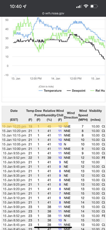
Looks like the streak is over! DCA with a 5-min obs of 19, giving us a temp of 19/20. Congrats, everyone!
-
I want to believe…
-
I think there was a discussion in the Banter thread a few days ago, if you scroll back past about 70 memes from 2015 lol
-
https://www.washingtonpost.com/weather/2022/01/13/winter-storm-east-coast-snow/ CWG’s write up, nothing new or terribly revelatory. My wish for 2022 is that the Post springs for an editor for this specific author. His writing is just *awful* and it drives me crazy that’s he’s become somehow the lead communicator for CWG…
-
Heh it would be the ultimate DCA-ing to end the streak with an 11:59pm low.
-
Welp looks like DCA DCA'd it...3:30pm obs was 30. We'll see if that ends up being accurate but unless there's some weird rounding error, looks like we'll record a high of 30 today.
-
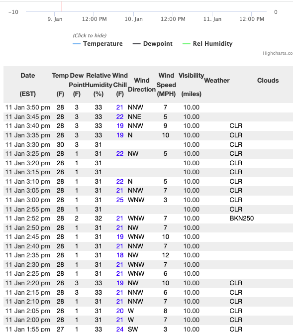
I keep checking the 5-min obs to see when DCA is gonna DCA the afternoon high temp. Been holding steady at 28 (which could be 28 or 29) since about 1, with a dewpoint fluctuating between 1 and 3. As a side note, I don't think I disagree with Judah Cohen on this statement: Radiational cooling at DCA has been tough and getting tougher. Dynamic cooling...you could make the argument that a big issue is that we just haven't had that many opportunities in the last few years, which has helped the sub-30 streak for highs go on as long as it has (while the sub-32 streak wasn't all that far off from "expected"). Anyway, salivation aside for next weekend's potential, it does look like a mighty cold airmass lurking around. Maybe the streak will end?
-
Looks like the lowest 5-min obs at DCA is 21, which with the weird Fahrenheit to Celsius back to Fahrenheit could also be 22. No teens still, and my guess is that the >=22 streak lives on too…
-
I am a bit worried about the cloud cover that looks like it's trying to move in--my guess is DCA bottoms out right at 20, breaking the sub-22 streak, but keeping the teens streak alive.
-
Thanks! I would definitely want to start with lessons (good thoughts on group vs private)--is there any resort around here that is "better" for beginners than the others?
-
Since skiing seems to be one thing to keep LR panic at bay, and there's a lot of knowledgable folks on here, I wanted to ask--does anyone have any tips/recommendations for adults learning to ski? I've always wanted to learn but am worried that it's something you have to learn as a kid (which in Houston...was not gonna happen). Thanks!
-
I’d wager Monday night is the best near-term chance for DCA to fall below 20. I’ve noticed (not at all revelatory, I know lol) that DCA and downtown is absolutely awful at radiatonal cooling, but if there’s cold pressing, it usually works out. Looks like Monday night will still have arctic cold pressing, something that’s been in remarkably short supply around here lately. I’m pretty optimistic for Monday night, but if that doesn’t work out, we will probably have to wait until after MLK to break the streak.
-
It seems like we as a board (probably all people) would do well to internalize that there aren’t really instances of a single factor determining outcomes with universal certainty. Case in point, the ENSO state is not the sole deterministic factor of our sensible weather for met winter—it contributes, for sure, but you can’t say La Niña means our weather will be “x” or will not be “y” with 100% certainty. @Maestrobjwa, you’re not the only one doing this, but I feel like you’ve spent the last few years trying to find the “one thing” to hang your hat on to know the weather…but there isn’t “one thing.” There’s no period of return, no macro scale weather pattern that is going to be entirely deterministic and tell us that we are or aren’t getting a big snowstorm. There are so many fine chaotic details that you can’t see or define, certainly not on a seasonal scale, and for me, that’s what makes this hobby fun! But you have to be comfortable with uncertainty (which is probably a good life lesson for a very broad swath of the population). Anyway just my 2 cents as someone whose been lurking here since 2008
-
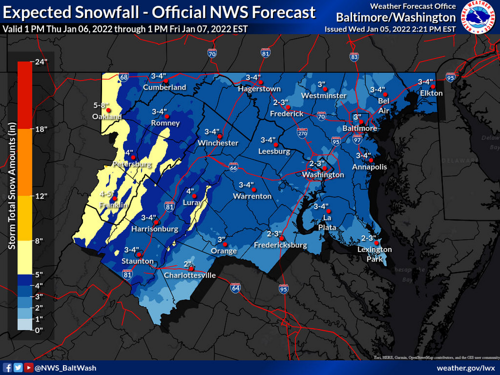
NWS seems to be seeing the dual-band scenario in their latest accumulation maps too: Still, I'll take 2-3" and be happy!
-
Coldest max last winter at DCA was 31, with a few other days at 32; no days at or below 32 in winter 2020. The last time we spent a full day below 30 was early Feb 2019, so hopefully the cold air pans out the next few weeks!
-
Midnight obs at DCA is 29…I don’t think tonight will be the night for the city, sadly…
-
Eh most of the stations on Wunderground in the urban core are within a degree or two of DCA (the Hill is ~2 degrees warmer and Rosslyn is ~2 degrees cooler, for example). Generally DCA is pretty representative of the urban core. The main explanation is density—get more than three miles away from DCA (fewer if you go south and west), and the landscape has much more green space and far less concrete. DCA may not be the most representative of Washington as a whole, but it’s not out of line with the immediate vicinity with similar levels of development.
-
About 8” here in Petworth. Got a nice photo of the lions on the 16th St bridge over Piney Branch in their holiday bows. https://imgur.com/a/HSP8Qyz
-
Despite having gone from 28 to 30 (??) between 6-7pm, the forecast minimum at DCA tonight is 18, which would be the coldest since Feb 2, 2019. Can we get there??? Still waiting on true Arctic air for a sub-30 degree high temp. Last sub-30 day at DCA: Feb 1, 2019, but I’m hopeful we will see that in the next couple weeks. (As a side note, we’re still waiting on the first sub-40 high temp at DCA, but that seems pretty given for tomorrow)
-
The Seasonal Snowfall Futility Markers
WinterFire replied to North Balti Zen's topic in Mid Atlantic
Record high annual minimum temp in 2021, and a record high “lowest maximum” temp in 2020. I hate how much I’d give for the “historic warmth” of the winters of the late-2000s and early-2010s. Worse still, I’m sure I’ll have the same feelings about these years in the next decade… -
I'd be curious to hear what you (and others) think is causing the ridiculously resilient SE ridge this winter. Is it just that the western trough continues to dig more than initially thought, while maintaining a less-than-ideal mean axis?? Is there something upstream that's helping to force the ridge? SSTs are pretty warm in the Gulf/off the SE coast but it doesn't seem to be exceptionally warm, so I imagine that's a contributor but not necessarily what causes it.
-
The Seasonal Snowfall Futility Markers
WinterFire replied to North Balti Zen's topic in Mid Atlantic
This stat was tossed off a few days ago but I’ve been following it for a while—it’s been a long time since DCA was in the teens, and with the way things are going, I’d bet we push four years before we dip into the teens again… (Off-topic, I know, but this seemed like the best fit since we don’t have a panic room anymore) -
So I seriously doubt that there is anything that anyone could say to convince you that there isn’t some kind of conspiracy at DCA, but I urge you to go browse the New England forum and see how they feel about the observations at Logan (especially compared to Blue Hill Observatory). Or you can check CWG’s comparisons of their downtown station vs DCA, which are generally within 1-2 degrees of each other. People have been observing the heat island effect for years, the data is all there for you to find! And—you say your eyes are deceiving you but you don’t actually live by DCA. So what personal observations are you basing this off of? Do you have an independent sensor in Crystal City or on The Wharf? Could you share these observations so we know how your eyes are deceiving you?
-
Feb Long Range Discussion (Day 3 and beyond) - MERGED
WinterFire replied to WinterWxLuvr's topic in Mid Atlantic
Sure, I don't think it's the only hostile issue here. I mentioned the Northern Stream dominance this year, which would help to explain why 40N or so and north are at/above climo. There's also a certain amount of bad luck too, of course, but the warming SST profiles do impact temps year round--the biggest difference for our region vs further north is that we were super marginal to begin with. So Philly can warm from 27 to 29 and be fine; we can't warm from 31 to 33 and be fine in mid-winter. Anyway, all of that is to say that, while we are stuck with global warming as an influence in our increasingly-crappy winters, I am hopeful that there is a specific driver in this winter (the NS dominance) that isn't permanent. But for now, it's hard to feel confident in any of the colder/wetter solutions we've been seeing.


