-
Posts
4,176 -
Joined
-
Last visited
Content Type
Profiles
Blogs
Forums
American Weather
Media Demo
Store
Gallery
Posts posted by midatlanticweather
-
-
36.9 here in Purcellville for the low. Woo.
-
 1
1
-
-
1 hour ago, BlizzardNole said:
I believe that's right -- October 10, 1979. I was in middle school in Calvert County and everyone was stunned seeing 2-3" of snow on the ground and still-green trees. Can't believe it's been 44 years!
It was.. Even in Richmond Virginia it snowed some on October 10, 1979. I remember because it was on my brother's birthday. Crazy!
-
38.2 for a low! A very nice day out there! Beautiful!
-
-
22 minutes ago, mappy said:
low of 41 -- picked up .12 last evening
Same low, just 0.14 rain
-
39.5 for a low
-
 1
1
-
-
0.43 so far. Nice watering
-
 1
1
-
-
-
BWI: Oct 27
IAD: Oct 27
DCA: Nov 11
RIC: Nov 4
BWI departure +0.8
-
Looks like a cool shot mid-month and dry conditions ahead! I do not love this pattern.
-
Shouldn't there be a first frost/freeze contest soon?

-
 1
1
-
-
1.98 total here in Purcellville. Very happy with the rainfall and the lack of true severe weather in my area (though that tree fall made it on the Weather Channel!)
-
 1
1
-
-
-
-
3 minutes ago, TSSN+ said:
Models about cut qpf in half with 12z runs
Noted the same thing!
-
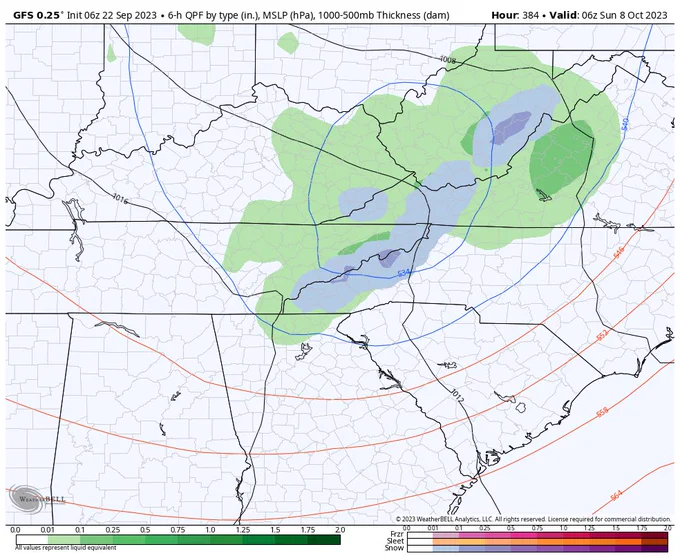
I did not see this earlier! Digital Snow on GFS 384

-
 2
2
-
-
Gfs is drier out west. Sub tropical vibes.interesting run
-
16 minutes ago, mattie g said:
Or equating September wavelengths or upper air features to those in the depths of winter is a bit simplistic.
Atmospheric memory! And all that jazz
-
 1
1
-
-
Had an extra shower last night about 1:30 am. Total for that event was 0.38 in my backyard. Bit of a let down. Next weekend is a big question mark for what will happen. If I were betting, I woukd bet on dry.
-
Lovely 49 degrees this morning for a low.
-
52.9 for a low! Looking forward to some 40s tonight!

Hope we can get some rain on Sunday! Late in the day is good!
-
57 for a low and some lower humidity. This is acceptable.
-
 1
1
-
-
BULLETIN - EAS ACTIVATION REQUESTED Tornado Warning National Weather Service Mount Holly NJ 1225 AM EDT Wed Sep 13 2023 The National Weather Service in Mount Holly NJ has issued a * Tornado Warning for... Northeastern Talbot County in eastern Maryland... South central Queen Anne`s County in northeastern Maryland... * Until 100 AM EDT. * At 1224 AM EDT, a severe thunderstorm capable of producing a tornado was located over Copperville, or 7 miles northwest of Easton, moving northeast at 20 mph. HAZARD...Tornado. SOURCE...Radar indicated rotation. IMPACT...Flying debris will be dangerous to those caught without shelter. Mobile homes will be damaged or destroyed. Damage to roofs, windows, and vehicles will occur. Tree damage is likely. * Locations impacted include... Easton, Matthews, Skipton, Wye Mills, Copperville and Cordova. PRECAUTIONARY/PREPAREDNESS ACTIONS... TAKE COVER NOW! Move to a basement or an interior room on the lowest floor of a sturdy building. Avoid windows. If you are outdoors, in a mobile home, or in a vehicle, move to the closest substantial shelter and protect yourself from flying debris. Tornadoes are extremely difficult to see and confirm at night. Do not wait to see or hear the tornado. TAKE COVER NOW! To report severe weather contact your nearest law enforcement agency. They will send your report to the National Weather Service office in Mount Holly NJ. Torrential rainfall is occurring with this storm, and may lead to flash flooding. Do not drive your vehicle through flooded roadways. -
BULLETIN - EAS ACTIVATION REQUESTED
Tornado Warning
National Weather Service Baltimore MD/Washington DC
1156 PM EDT Tue Sep 12 2023

The National Weather Service in Sterling Virginia has issued a

* Tornado Warning for...
  Central Harford County in northern Maryland...
  East central Baltimore County in northern Maryland...

* Until 1230 AM EDT.

* At 1155 PM EDT, a severe thunderstorm capable of producing a
  tornado was located over Perry Hall, or near Middle River, moving
  northeast at 20 mph.

  HAZARD...Tornado and quarter size hail.

  SOURCE...Radar indicated rotation.

  IMPACT...For those in the direct path of a tornado touchdown,
           flying debris will be dangerous to those caught without
           shelter. Damage to roofs, siding, and windows may occur.
           Mobile homes may be damaged or destroyed. Tree damage is
           likely.

* This dangerous storm will be near...
  Bel Air South, Bel Air North, Fallston, Kingsville, and Pleasant
  Hills around 1200 AM EDT.
  Riverside and Perryman around 1205 AM EDT.

Other locations impacted by this tornadic thunderstorm include
Nottingham, Edgewood, Fork, Benson, Magnolia, Bradshaw, Bynum,
Joppatowne, Abingdon, and Joppa.

PRECAUTIONARY/PREPAREDNESS ACTIONS...

TAKE COVER NOW! Move to a basement or an interior room on the lowest
floor of a sturdy building. Avoid windows. If you are outdoors, in a
mobile home, or in a vehicle, move to the closest substantial shelter
and protect yourself from flying debris.

&&


October Discobs 2023
in Mid Atlantic
Posted
0.21" total. Not much, but more than I thought at one point!