

midatlanticweather
-
Posts
4,634 -
Joined
-
Last visited
Content Type
Profiles
Blogs
Forums
American Weather
Media Demo
Store
Gallery
Posts posted by midatlanticweather
-
-
9 hours ago, mappy said:
You probably need to delete some of your attachments to make space to post more.
That was it!! Thank you
-
 2
2
-
-
I mean.. Why not start the year off with a little thing.. I can't post any graphics due to something up with my account, but I think some could dust Friday morning ..Higher elevations can boast on some high totals and wind. Ringing in the new start to winter weather possibilities.
-
1
-
-
Wild experience on my walk! I would get down to the bottom of a hill in a small area and the winds were calm and the temps pretty chilly. I would walk to the top of hills and there would be a warm breeze and temps were likely 5+ degrees warmer. It was like I would get to the top of the hill and someone turned on the heater with the air blowing.. get to the bottom of the hill and there was no wind and much cooler.
-
2
-
-
17 minutes ago, clskinsfan said:
Not having my first flakes out here by Nov 15th usually means a back loaded winter. Clearly nothing scientific about it. But it is rare to not have some flakes by that date here.
Seeing flakes in the forecast for Thursday Night.. we shall see
-
3
-
-
Was a breezy walk this morning! 53.7 degrees! Feels like fall!
")
-
7 minutes ago, JenkinsJinkies said:
So no can kick? Thanksgiving pattern flip is still on?
There is still time! LOL! At this point we have pretty high confidence next weekend will get colder and windy. Western slopes in WV/MD have a good possibility of warned snow (maybe the B word, but we would need to see how things pan out!) -
As of now, models show it relaxing Thanksgiving week, so normal temps look like they will return... BUT that is all model talk. I think we need some run consistency beyond next weekend.... but I do not think the pattern supports sustained colder conditions. People with better credentials can confirm. In general though, I do not see a blowtorch in the extended. BUT, that can change too! LOL -
18Z GFS brings some serious upslope! I'm seeing estimates that it will be over 30 inches for some of the Ridges in WV.
I would attach an image, but I am limited to small file sizes for some reason!
-
0.32 total for me. Not too great
-
-
8 minutes ago, WxUSAF said:
6z gfs snow for the holiday week. It’s not a crazy evolution either…
Thinking the same. If we want to get snow this time of year, a follow-up wave is a good option!
-
2
-
-
7 minutes ago, MN Transplant said:
The 360 hour Euro is live. Lord help us all.
And the 144 hr 6z and 18z!
Time for weenie dreams and heartbreaks from Lala land!

-
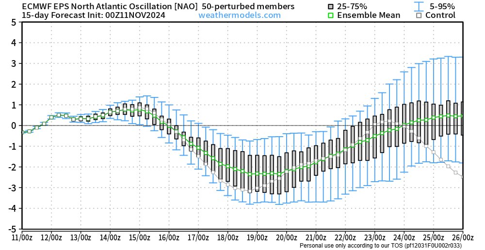
Looks like we go negative, but turn it around at the end of the month... unless you go with the control! LOL! Not a strong positive.. but there... the hints at something around then could have some small support?
-
1
-
-
0.22 total - I will take anything, but that is not going to do much to the drought
-
Well ... things look a bit interesting in the long range.
-
We got a follow up wave action in the extended on the GFS! Rain changing to snow... 300 hrs away! Should work out perfectly! First window??? LOL

-
2
-
-
Negative NAO?
-
So warm of a walk this morning! At least it was a bit better than yesterday as I had a slight breeze and some clouds.. but wow. This did not feel like fall... but the trees said otherwise! Low of 57. No rain either!
-
BWI: 11”
DCA: 9.3”
IAD: 15”
RIC: 7”
Tiebreaker SBY: 6.7”
-
1
-
-
The calm this morning made the walk not great! We were approaching 55 when I was getting to the end! Miss the colder morning walks! Low last night was just 45!
-
1
-
-
The air was so calm this morning on my walk, but it also got warm too quickly! Last night's low was 36, but by 7 a.m., it was up in the 40s.
-
The pattern is relentless. It is so boring!! 77.6 for a high Friday
-
1
-
 1
1
-
-
Ground was wet this am - but that will not last long as we get these winds and lower humidity the rest of the day!
Happy November! Let's hope we can shake this pattern and some wild things happen to make it set up a December to Remember!
-
I had a balmy 83.7 earlier! Still 82. I was doing a few things outside and it was soooo hot!
-
1
-
-
Nice cold morning walk! 31.0 degrees on the dot for a low. That is officially my first day below freezing this year. Frost was nice! Walk was wonderful! Walk is gonna be warmer the next few days!
-
1
-

November Discobs 2024
in Mid Atlantic
Posted
Oh man is it windy. Sustained at 41mph for a bit. Has to have gusted over 50 multiple times.