StantonParkHoya
-
Posts
2,159 -
Joined
-
Last visited
Content Type
Profiles
Blogs
Forums
American Weather
Media Demo
Store
Gallery
Everything posted by StantonParkHoya
-

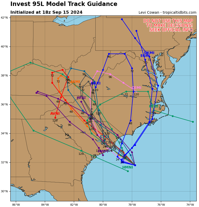
2024 Atlantic Hurricane Season
StantonParkHoya replied to Stormchaserchuck1's topic in Tropical Headquarters
12z ICON extrapolated looks heading for Corpus Christi — Houston -
2024 Atlantic Hurricane Season
StantonParkHoya replied to Stormchaserchuck1's topic in Tropical Headquarters
Pretty wild path on GFS. I’m skeptical of such an anomalously digging trough in late September to cause a full recurve. A landfall Mobile-Big Bend then NE seems more plausible. -
2024 Atlantic Hurricane Season
StantonParkHoya replied to Stormchaserchuck1's topic in Tropical Headquarters
Call me skeptical that a TC zips from the shores of Ol’ Mexico completely across the gulf to Florida like that -
2024 Atlantic Hurricane Season
StantonParkHoya replied to Stormchaserchuck1's topic in Tropical Headquarters
18z GFS with some big changes. Less trough dig, more ridging into gulf, takes Cat 4/5 into Louisiana coast -
2024 Atlantic Hurricane Season
StantonParkHoya replied to Stormchaserchuck1's topic in Tropical Headquarters
Less dust when the area is flooding -
2024 Atlantic Hurricane Season
StantonParkHoya replied to Stormchaserchuck1's topic in Tropical Headquarters
Seems like the model average is around Mobile -
2024 Atlantic Hurricane Season
StantonParkHoya replied to Stormchaserchuck1's topic in Tropical Headquarters
Will be interesting to follow the timing and the trough interaction. GFS does it again but the set up over the US MW is quite different each run. -
Potential Tropical Cyclone Eight—50mph/1006mb
StantonParkHoya replied to WxWatcher007's topic in Tropical Headquarters
Pretty sure those are all squall related. I don’t see anything from Topsail over 35. -
Potential Tropical Cyclone Eight—50mph/1006mb
StantonParkHoya replied to WxWatcher007's topic in Tropical Headquarters
Saving grace for immediate coastal areas it pertains for fresh water flooding is three-fold: 1) sandy base soils allow for maximum drainage; 2) it’s post-summer-season, so lower population; 3) most houses are on stilts. -
Potential Tropical Cyclone Eight—50mph/1006mb
StantonParkHoya replied to WxWatcher007's topic in Tropical Headquarters
All I can think of is if this was snow -
Potential Tropical Cyclone Eight—50mph/1006mb
StantonParkHoya replied to WxWatcher007's topic in Tropical Headquarters
Definitely feels like a fall coastal, not tropical -
Potential Tropical Cyclone Eight—50mph/1006mb
StantonParkHoya replied to WxWatcher007's topic in Tropical Headquarters
If 3 inches of rain is “substantial”, then sure -
Potential Tropical Cyclone Eight—50mph/1006mb
StantonParkHoya replied to WxWatcher007's topic in Tropical Headquarters
Models tightening up on location now. Georgetown, SC has been the hot spot last few years.
-
Potential Tropical Cyclone Eight—50mph/1006mb
StantonParkHoya replied to WxWatcher007's topic in Tropical Headquarters
6z GEFS looks like between CHS and MYR as maybe a TD note: RAH believes this will be a subtropical system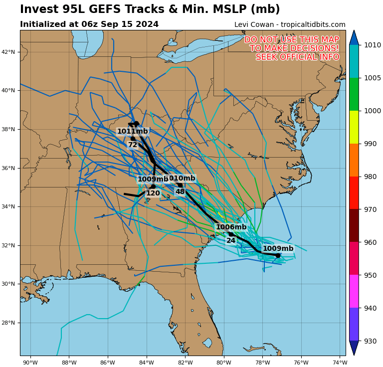
-
Potential Tropical Cyclone Eight—50mph/1006mb
StantonParkHoya replied to WxWatcher007's topic in Tropical Headquarters
‘Twas a joke. Just not much of a storm. -
Potential Tropical Cyclone Eight—50mph/1006mb
StantonParkHoya replied to WxWatcher007's topic in Tropical Headquarters
18z GFS says it may not rain in Raleigh -
Potential Tropical Cyclone Eight—50mph/1006mb
StantonParkHoya replied to WxWatcher007's topic in Tropical Headquarters
12z Euro is… not much -
Potential Tropical Cyclone Eight—50mph/1006mb
StantonParkHoya replied to WxWatcher007's topic in Tropical Headquarters
ICON looks like a nor’easter lol. DMV folks would be hyped if it was January. -
Potential Tropical Cyclone Eight—50mph/1006mb
StantonParkHoya replied to WxWatcher007's topic in Tropical Headquarters
12z GFS has this inland by Monday morning. Sped the time up. -
Potential Tropical Cyclone Eight—50mph/1006mb
StantonParkHoya replied to WxWatcher007's topic in Tropical Headquarters
Please tell me we’re not trying to extrapolate the HRRR out to 84 hours on here -
2024 Atlantic Hurricane Season
StantonParkHoya replied to Stormchaserchuck1's topic in Tropical Headquarters
From a sensible weather standpoint, it doesn’t really matter much, it’s generally the same impacts. -
2024 Atlantic Hurricane Season
StantonParkHoya replied to Stormchaserchuck1's topic in Tropical Headquarters
0z GFS with a subtropicalish looking weak low coming into SE NC. Couple inches of rain. -
2024 Atlantic Hurricane Season
StantonParkHoya replied to Stormchaserchuck1's topic in Tropical Headquarters
NHC not convinced the low becomes tropical. Could be subtropical. -
2024 Atlantic Hurricane Season
StantonParkHoya replied to Stormchaserchuck1's topic in Tropical Headquarters
You mean the Austin that is 175 miles inland? Not sure what you’d expect there even with a cat 4 on the coast. -
it’s just an oddity because all of the small number of storms have found land it is objectively a quiet season so far when your point of measure is a predicted 25 named storms