

StantonParkHoya
-
Posts
1,965 -
Joined
-
Last visited
Content Type
Profiles
Blogs
Forums
American Weather
Media Demo
Store
Gallery
Posts posted by StantonParkHoya
-
-
5 minutes ago, SnowGoose69 said:
The problem is the dry air issue seems non existent this time so something else is going to have to save it.
Shear forecast to increase as it approaches
-
 1
1
-
 1
1
-
 1
1
-
-
Outside of Beryl, every other storm has struggled this year. Let’s hope that trend continues.
-
1
-
-
Just now, CheeselandSkies said:
Eh? Those aren't even out yet on Tidbits.
-
3
-
-
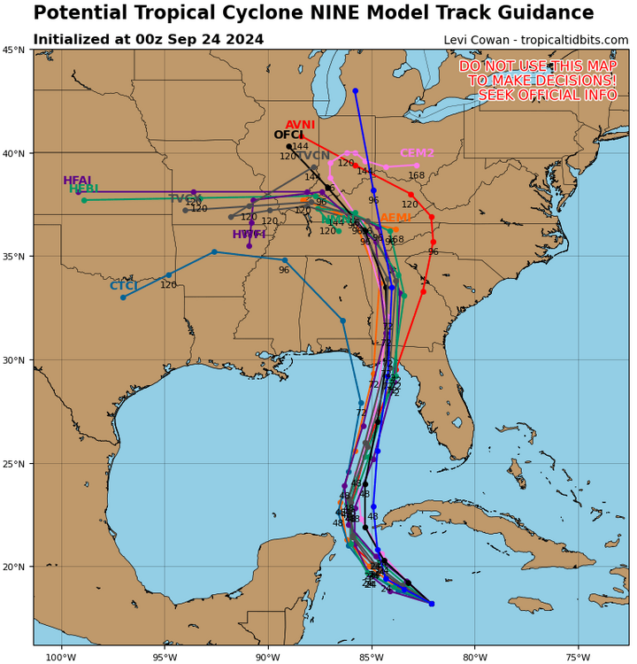
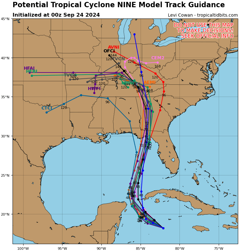
0z hurricane models really tight from Apalachicola to Atlanta
-
1
-
-
18z GFS weaker and sw of 12z
-
3 minutes ago, CurlyHeadBarrett said:
WDYM tightened up
All I'm seeing is fucking downtrending EVERY SINGLE TIME
I’m talking about spread on landfall location
-
Models have definitely tightened up today
-
GFS kind of looks convective feedbacky to me the way it jumps the low with the convection. Don’t know if that’s possible at that hour at that resolution but whatever.
its only 1000 miles different from 18z
CMC is in SW Arkansas at 222, GFS is off Cape of Maine.
-
3 minutes ago, dbullsfan said:
So this is either gonna be a major hurricane hitting Tampa or a Tropical Storm hitting Texas or somewhere in between. Got it
.Or it could always be…nothing at all
-
4
-
2
-
-
What’s 1200 miles amongst friends?
-
 3
3
-
-
12z ICON extrapolated looks heading for Corpus Christi — Houston
-
Pretty wild path on GFS. I’m skeptical of such an anomalously digging trough in late September to cause a full recurve. A landfall Mobile-Big Bend then NE seems more plausible.
-
20 minutes ago, Seminole said:
6Z GFS further west and misses the GOM loop current. Still a solid CAT 3 with a massive wind field. Landfall near Port St Joe.
Call me skeptical that a TC zips from the shores of Ol’ Mexico completely across the gulf to Florida like that
-
1
-
-
18z GFS with some big changes. Less trough dig, more ridging into gulf, takes Cat 4/5 into Louisiana coast
-
1
-
1
-
-
1 minute ago, CurlyHeadBarrett said:
Less dust when the area is flooding
-
1
-
1
-
-
Seems like the model average is around Mobile
-
Will be interesting to follow the timing and the trough interaction. GFS does it again but the set up over the US MW is quite different each run.
-
2
-
-
Pretty sure those are all squall related. I don’t see anything from Topsail over 35.
-
Saving grace for immediate coastal areas it pertains for fresh water flooding is three-fold: 1) sandy base soils allow for maximum drainage; 2) it’s post-summer-season, so lower population; 3) most houses are on stilts.
-
All I can think of is if this was snow
-
1
-
3
-
-
Definitely feels like a fall coastal, not tropical
-
3
-
-
15 minutes ago, USCG RS said:
This looks like it could cause somewhat substantial impacts in the Carolinas and Mid-Atlantic. This should be watched rather closely for those inland as well.
If 3 inches of rain is “substantial”, then sure
-
1
-
-

Models tightening up on location now. Georgetown, SC has been the hot spot last few years.
-
6z GEFS looks like between CHS and MYR as maybe a TD
note: RAH believes this will be a subtropical system
Major Hurricane Helene
in Tropical Headquarters
Posted