StantonParkHoya
-
Posts
2,159 -
Joined
-
Last visited
Content Type
Profiles
Blogs
Forums
American Weather
Media Demo
Store
Gallery
Everything posted by StantonParkHoya
-

Mid to long range discussion- 2025
StantonParkHoya replied to wncsnow's topic in Southeastern States
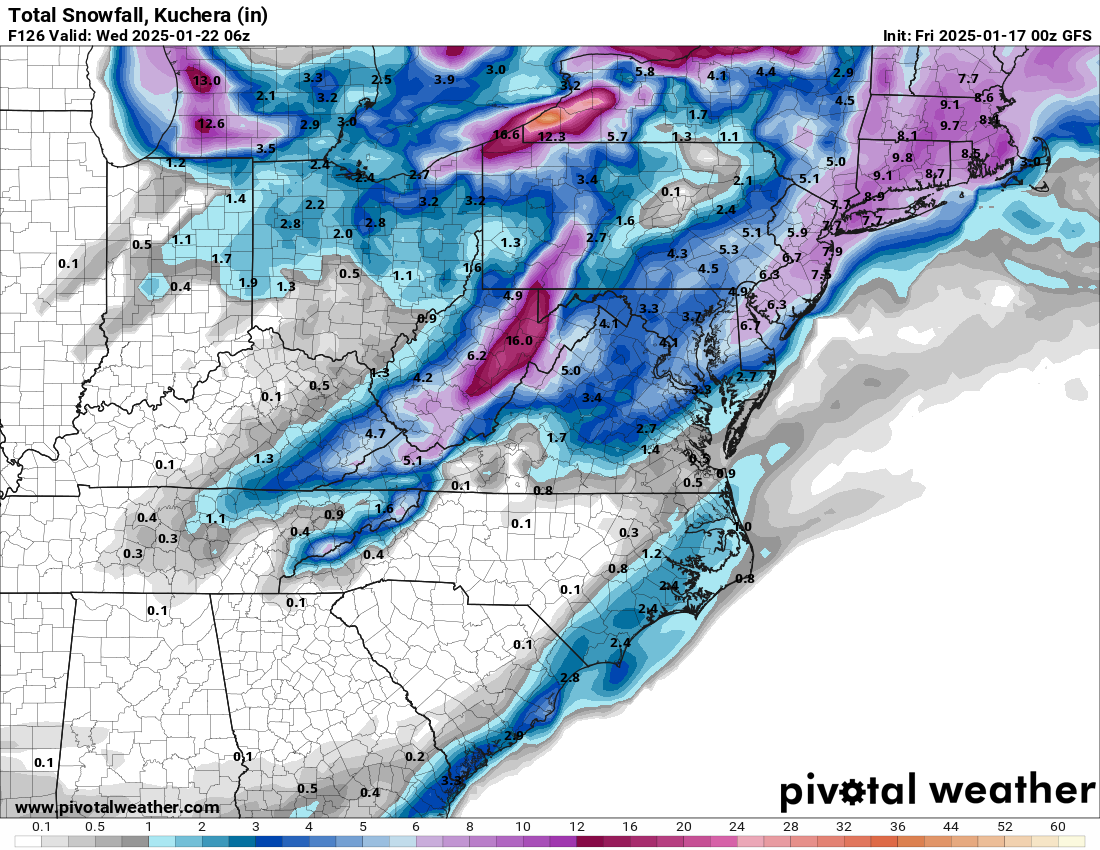
Somehow the CMC one upped its historic 12z run. That is bonkers. -
Mid to long range discussion- 2025
StantonParkHoya replied to wncsnow's topic in Southeastern States
One encouraging thing is all of the models seem to keep increasing down in TX and LA and look like they’re about to send a ton of moisture up the coast but it gets shunted. We’ll see if that increase keeps moving NE as we progress. -
Mid to long range discussion- 2025
StantonParkHoya replied to wncsnow's topic in Southeastern States

-
Mid to long range discussion- 2025
StantonParkHoya replied to wncsnow's topic in Southeastern States
It’s too bad because the Icon was Mr. Vibes last storm -
Mid to long range discussion- 2025
StantonParkHoya replied to wncsnow's topic in Southeastern States
It ain’t iconic this run -
Mid to long range discussion- 2025
StantonParkHoya replied to wncsnow's topic in Southeastern States
Isn’t it ironic that our next gen, artificial intelligence models look like maps from 1980s IBM computers -
Mid to long range discussion- 2025
StantonParkHoya replied to wncsnow's topic in Southeastern States

-
Mid to long range discussion- 2025
StantonParkHoya replied to wncsnow's topic in Southeastern States
Big movement considering didn’t the 12z have ZERO? -
Mid to long range discussion- 2025
StantonParkHoya replied to wncsnow's topic in Southeastern States
I’m calling it now. I think we see a big dog during tonight’s cycle — hopefully the euro run. Everyone knows the big possum walks late. -
Mid to long range discussion- 2025
StantonParkHoya replied to wncsnow's topic in Southeastern States
18z GEFS improved for ENC but worse west of 95 -
Mid to long range discussion- 2025
StantonParkHoya replied to wncsnow's topic in Southeastern States
Brick — you can stop looking at the second one. I need you focused on reeling in the Brickstorm -
Mid to long range discussion- 2025
StantonParkHoya replied to wncsnow's topic in Southeastern States

-
Mid to long range discussion- 2025
StantonParkHoya replied to wncsnow's topic in Southeastern States
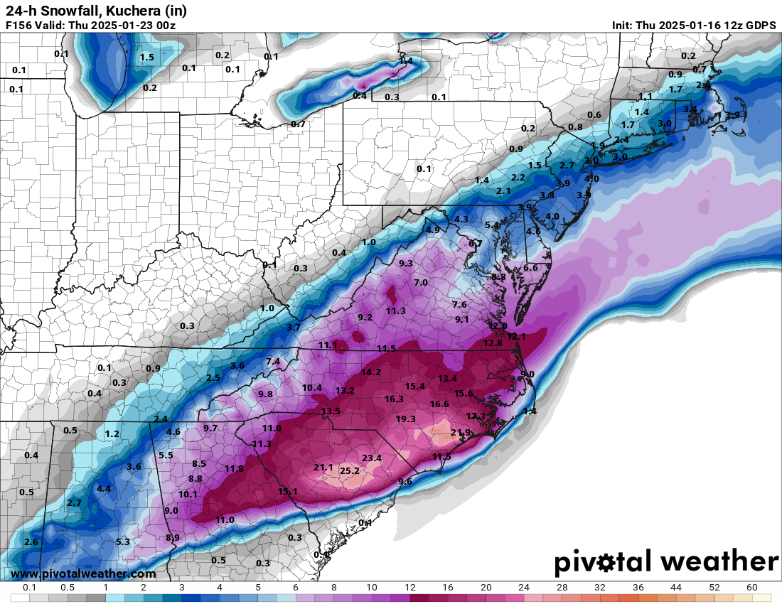
Definitely an improvement Congrats Wilmington!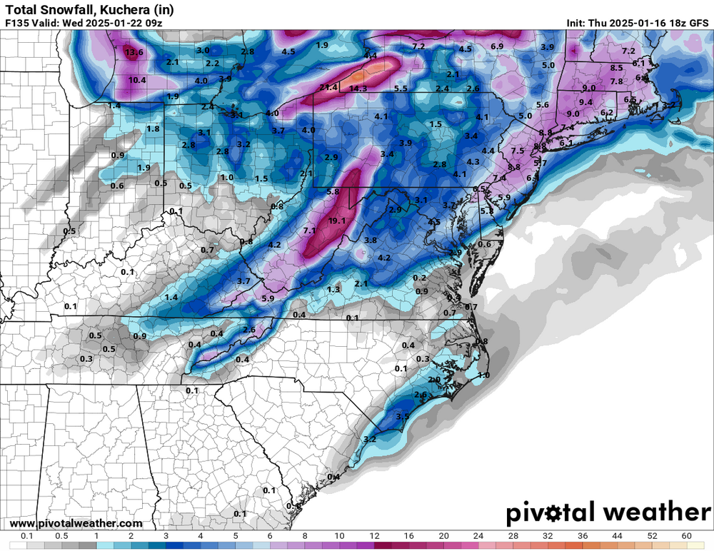
-
Mid to long range discussion- 2025
StantonParkHoya replied to wncsnow's topic in Southeastern States
Hard to tell. Timing has really slowed down today. -
Mid to long range discussion- 2025
StantonParkHoya replied to wncsnow's topic in Southeastern States
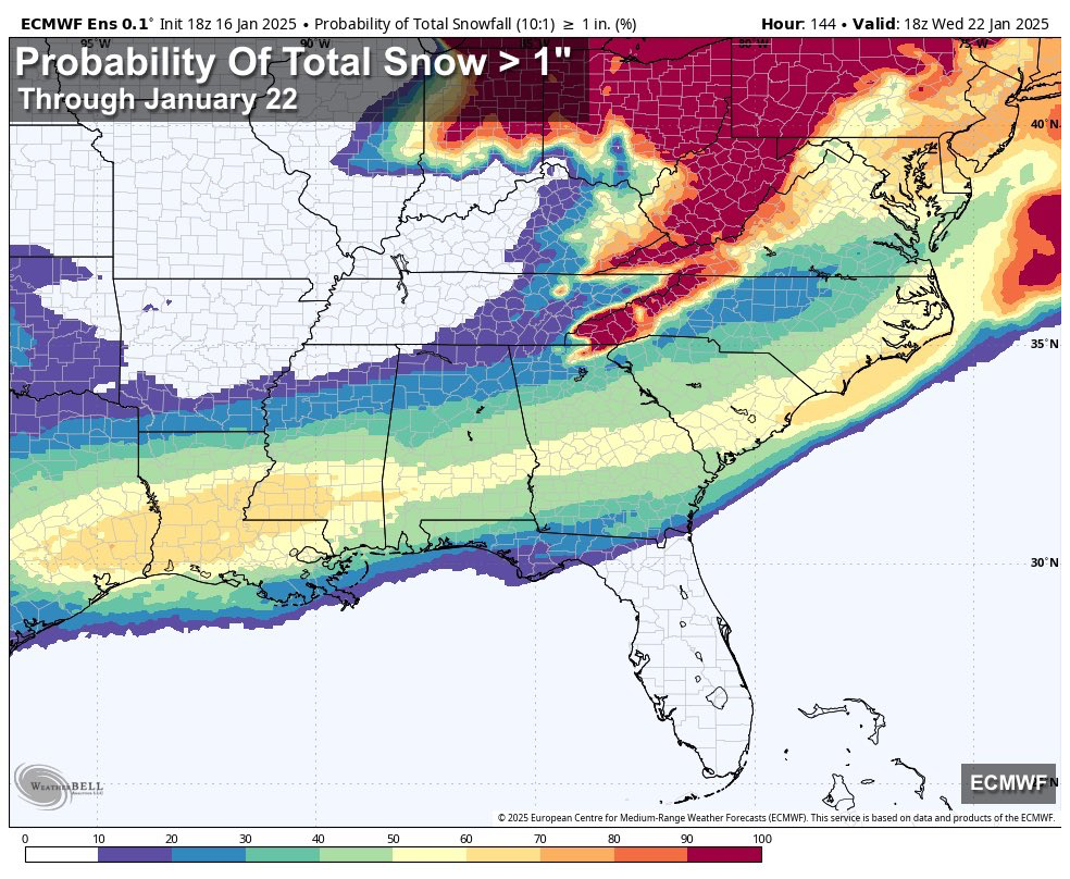
It’s limited but UKMET ensembles look pretty solid best I can tell So did ICON ensembles -
Mid to long range discussion- 2025
StantonParkHoya replied to wncsnow's topic in Southeastern States
There was a storm in maybe 2010 or 2011 where it snowed like 8 inches in Atlantic Beach and nothing in Havelock -
Mid to long range discussion- 2025
StantonParkHoya replied to wncsnow's topic in Southeastern States
Because the board has a higher representation from the foothills / mtns than population that actually live there -
Mid to long range discussion- 2025
StantonParkHoya replied to wncsnow's topic in Southeastern States
I’ll pick you up for our chase to Emerald Isle next Tuesday -
Mid to long range discussion- 2025
StantonParkHoya replied to wncsnow's topic in Southeastern States
Yes, the first wave is mostly a Wednesday system now on all models. It slowed down. -
Mid to long range discussion- 2025
StantonParkHoya replied to wncsnow's topic in Southeastern States
Most may find it counterintuitive but 2 of the 3 biggest snowfalls in North Carolina history came in the eastern part of the state, rather than the mountains https://www.wral.com/amp/21185118/ -
Mid to long range discussion- 2025
StantonParkHoya replied to wncsnow's topic in Southeastern States
It’s better in GA but arguably worse for NC -
Mid to long range discussion- 2025
StantonParkHoya replied to wncsnow's topic in Southeastern States
It’s first wave or bust, Brick. Always has been. -
Mid to long range discussion- 2025
StantonParkHoya replied to wncsnow's topic in Southeastern States
Nothing to see here
-
Mid to long range discussion- 2025
StantonParkHoya replied to wncsnow's topic in Southeastern States
Well, North Carolina is further north with colder temps so it makes sense -
Mid to long range discussion- 2025
StantonParkHoya replied to wncsnow's topic in Southeastern States
I never understood why people were even looking at that late week wave