StantonParkHoya
-
Posts
2,159 -
Joined
-
Last visited
Content Type
Profiles
Blogs
Forums
American Weather
Media Demo
Store
Gallery
Everything posted by StantonParkHoya
-
For several years from 2008-2012 or so Greenville NC was the snow capital of NC outside the mountains
-

2024-2025 Fall/Winter Mountain Thread
StantonParkHoya replied to Buckethead's topic in Southeastern States
They went with WWA for Watauga for 3-6. You think they’ll go higher? -
2024-2025 Fall/Winter Mountain Thread
StantonParkHoya replied to Buckethead's topic in Southeastern States
How are the Great Lakes unfrozen? It’s been the coldest January in 20 years -
Yeah, MHC using some pretty bold language on snow
-
Euro Ens is the #1 id want in my back pocket
-
This is definitely an i95 deal
-
Love a beautiful semi long duration overrunning event… so much better than bombs we have to worry when the warm nose is going to pop in
-
Mid to long range discussion- 2025
StantonParkHoya replied to wncsnow's topic in Southeastern States
I don’t think this is coming all the way back. I think you want to be in New Bern or Kinston here. -
Mid to long range discussion- 2025
StantonParkHoya replied to wncsnow's topic in Southeastern States
This is definitely lower -
Mid to long range discussion- 2025
StantonParkHoya replied to wncsnow's topic in Southeastern States
Burn the boats. Let’s ride. -
Mid to long range discussion- 2025
StantonParkHoya replied to wncsnow's topic in Southeastern States
Everyone grab some rope. Let’s get the ICON in the boat -
Mid to long range discussion- 2025
StantonParkHoya replied to wncsnow's topic in Southeastern States
Apparently the storm in New England for this weekend has trended so far nw that Boston went from 0 to nearly being rained on -
Mid to long range discussion- 2025
StantonParkHoya replied to wncsnow's topic in Southeastern States
What is this -
Mid to long range discussion- 2025
StantonParkHoya replied to wncsnow's topic in Southeastern States
I’m going to be negative and shitty today to try something different. I hate them. -
Mid to long range discussion- 2025
StantonParkHoya replied to wncsnow's topic in Southeastern States
Disaster! Yay! -
Mid to long range discussion- 2025
StantonParkHoya replied to wncsnow's topic in Southeastern States
We cannot win. Why can’t we just get these models to start falling in line. -
Mid to long range discussion- 2025
StantonParkHoya replied to wncsnow's topic in Southeastern States
Yes it would be a higher ratio, thus 0.8 would be a foot of snow most likely -
Mid to long range discussion- 2025
StantonParkHoya replied to wncsnow's topic in Southeastern States
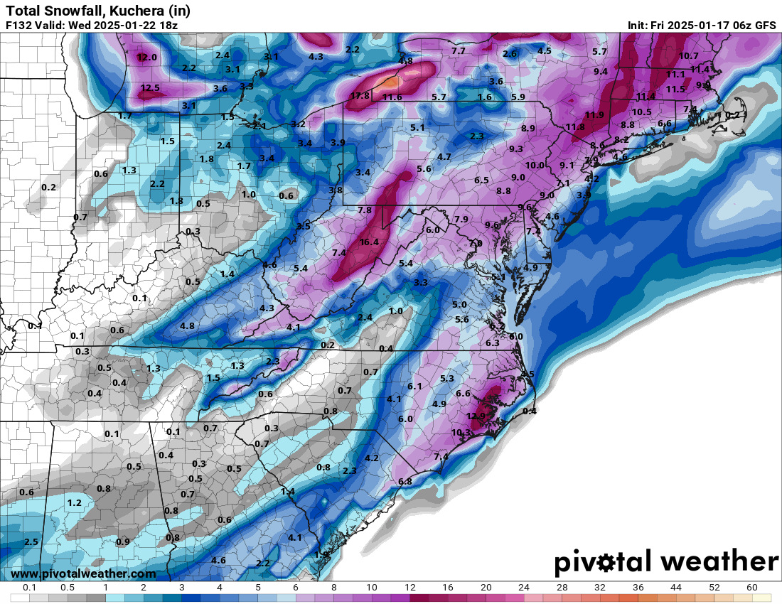
Does anyone have the 6z Euro snow map? I heard it improved -
Mid to long range discussion- 2025
StantonParkHoya replied to wncsnow's topic in Southeastern States
It went to hell -
Mid to long range discussion- 2025
StantonParkHoya replied to wncsnow's topic in Southeastern States
DGEX me! -
Mid to long range discussion- 2025
StantonParkHoya replied to wncsnow's topic in Southeastern States
I’m not biting until the ICON gets on board -
Mid to long range discussion- 2025
StantonParkHoya replied to wncsnow's topic in Southeastern States
Funny that yesterday we had the EPS and not the GFS now it’s flipped. Tough to get the band together. -
Mid to long range discussion- 2025
StantonParkHoya replied to wncsnow's topic in Southeastern States
love where we sit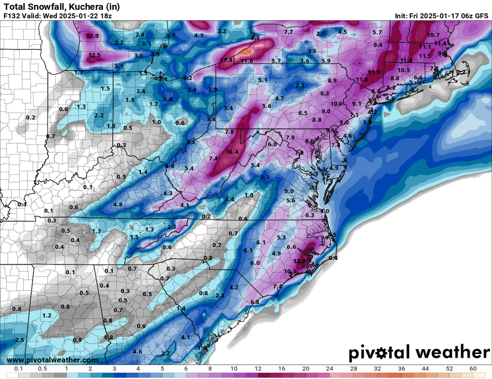
-
Mid to long range discussion- 2025
StantonParkHoya replied to wncsnow's topic in Southeastern States
lol the pink on the CMC map isn’t freezing rain, it’s a snow so heavy it ran off the scale. Amazing. An all time run. Bookmarked. -
Mid to long range discussion- 2025
StantonParkHoya replied to wncsnow's topic in Southeastern States
Actually some good old Canadian trailer park crystal meth