StantonParkHoya
-
Posts
2,159 -
Joined
-
Last visited
Content Type
Profiles
Blogs
Forums
American Weather
Media Demo
Store
Gallery
Everything posted by StantonParkHoya
-

February 19-20 Major Winter Storm Threat
StantonParkHoya replied to NorthHillsWx's topic in Southeastern States
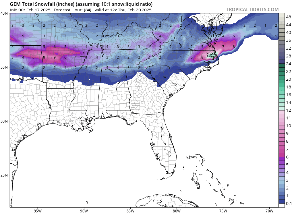
All the in house models and high res keep the snow / ice line further south -
February 19-20 Major Winter Storm Threat
StantonParkHoya replied to NorthHillsWx's topic in Southeastern States
I don’t love that run for RDU -
February 19-20 Major Winter Storm Threat
StantonParkHoya replied to NorthHillsWx's topic in Southeastern States
March starts next week. Ain’t always a “next time” maybe a next winter -
February 19-20 Major Winter Storm Threat
StantonParkHoya replied to NorthHillsWx's topic in Southeastern States
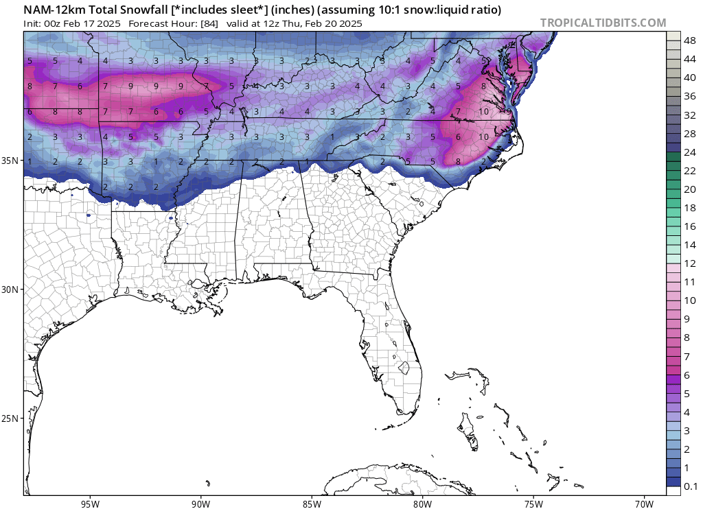
NAM had 5 inches for RDU at 6z -
February 19-20 Major Winter Storm Threat
StantonParkHoya replied to NorthHillsWx's topic in Southeastern States
Maybe I’m overly optimistic or just have different expectations but for RDU I’d rather sacrifice QPF for all snow. I despise ZR and find sleet futile. So the southern trends are good in that regard, and I believe it will juice back up starting tonight. -
February 19-20 Major Winter Storm Threat
StantonParkHoya replied to NorthHillsWx's topic in Southeastern States
id take the 6z GFS and roll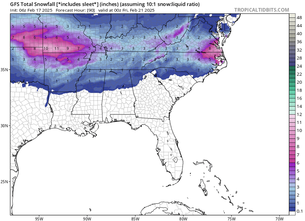
-
February 19-20 Major Winter Storm Threat
StantonParkHoya replied to NorthHillsWx's topic in Southeastern States
Yikes. Off the bed! -
February 19-20 Major Winter Storm Threat
StantonParkHoya replied to NorthHillsWx's topic in Southeastern States
Interesting time for this place to die -
February 19-20 Major Winter Storm Threat
StantonParkHoya replied to NorthHillsWx's topic in Southeastern States
Canadian was another shift south with the heaviest strip of snowfall -
February 19-20 Major Winter Storm Threat
StantonParkHoya replied to NorthHillsWx's topic in Southeastern States
-
February 19-20 Major Winter Storm Threat
StantonParkHoya replied to NorthHillsWx's topic in Southeastern States
0z GFS marginally better than 18z and a touch colder -
February 19-20 Major Winter Storm Threat
StantonParkHoya replied to NorthHillsWx's topic in Southeastern States
Is GFS a hair south of 18z or are my eyes deceiving me -
February 19-20 Major Winter Storm Threat
StantonParkHoya replied to NorthHillsWx's topic in Southeastern States
Most of that is sleet in Wake
-
February 19-20 Major Winter Storm Threat
StantonParkHoya replied to NorthHillsWx's topic in Southeastern States
NAM shifting temps and SLPs hundreds of miles between runs… WE DO SCIENCE IN THIS COUNTRY -
February 19-20 Major Winter Storm Threat
StantonParkHoya replied to NorthHillsWx's topic in Southeastern States
That would — not feed families — rather we would be going to the soup kitchen. -
I guess open runway? We never got above 40 mph here and I’m 8 miles from RDU
-
February 19-20 Major Winter Storm Threat
StantonParkHoya replied to NorthHillsWx's topic in Southeastern States
What’s our frontogenisis / lift sitch? -
February 19-20 Major Winter Storm Threat
StantonParkHoya replied to NorthHillsWx's topic in Southeastern States
JB has never seen a storm he couldn’t turn into a Kocin big city nor’easter -
February 19-20 Major Winter Storm Threat
StantonParkHoya replied to NorthHillsWx's topic in Southeastern States
Yeah they are not in line with bordering offices -
February 19-20 Major Winter Storm Threat
StantonParkHoya replied to NorthHillsWx's topic in Southeastern States
All the models look pretty similar now if you count GEFS coming in line -
February 19-20 Major Winter Storm Threat
StantonParkHoya replied to NorthHillsWx's topic in Southeastern States
Yep, and sun angle warms that top layer like a magnifying glass. There’s a reason fruit trees bloom in the Triangle in the first week of March. -
February 19-20 Major Winter Storm Threat
StantonParkHoya replied to NorthHillsWx's topic in Southeastern States
Tough to get icy roads with light rates in late February -
February 19-20 Major Winter Storm Threat
StantonParkHoya replied to NorthHillsWx's topic in Southeastern States
At least we will get some daytime snow with this one -
February 19-20 Major Winter Storm Threat
StantonParkHoya replied to NorthHillsWx's topic in Southeastern States
RDU ~2” snow/sleet -
February 19-20 Major Winter Storm Threat
StantonParkHoya replied to NorthHillsWx's topic in Southeastern States
I know they sobbed having to make a winter weather map