OrdIowPitMsp
-
Posts
2,791 -
Joined
-
Last visited
Content Type
Profiles
Blogs
Forums
American Weather
Media Demo
Store
Gallery
Everything posted by OrdIowPitMsp
-
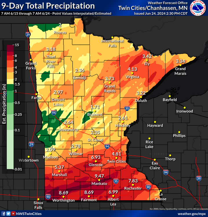
June finished with an average temperature of 69.5 which is -0.2 below average. This is the first June without a 90 in Minneapolis since 2016. The 7.27” of precipitation is 2.69” above average and makes this the 14th wettest June on record.
-

Spring/Summer '24 Banter and Complaint Thread
OrdIowPitMsp replied to IWXwx's topic in Lakes/Ohio Valley
Life hack: If you don’t own a lake house just have your kid befriend someone who does. One heck of a 2nd bday party. -
1pm at the airport, it’s 68/41 under full sun. Doesn’t get better then that on June 30th.
-
UHI kept us relatively mild overnight, only got down to 53.
-
High of 72 today. Stellar evening currently 66/48
-
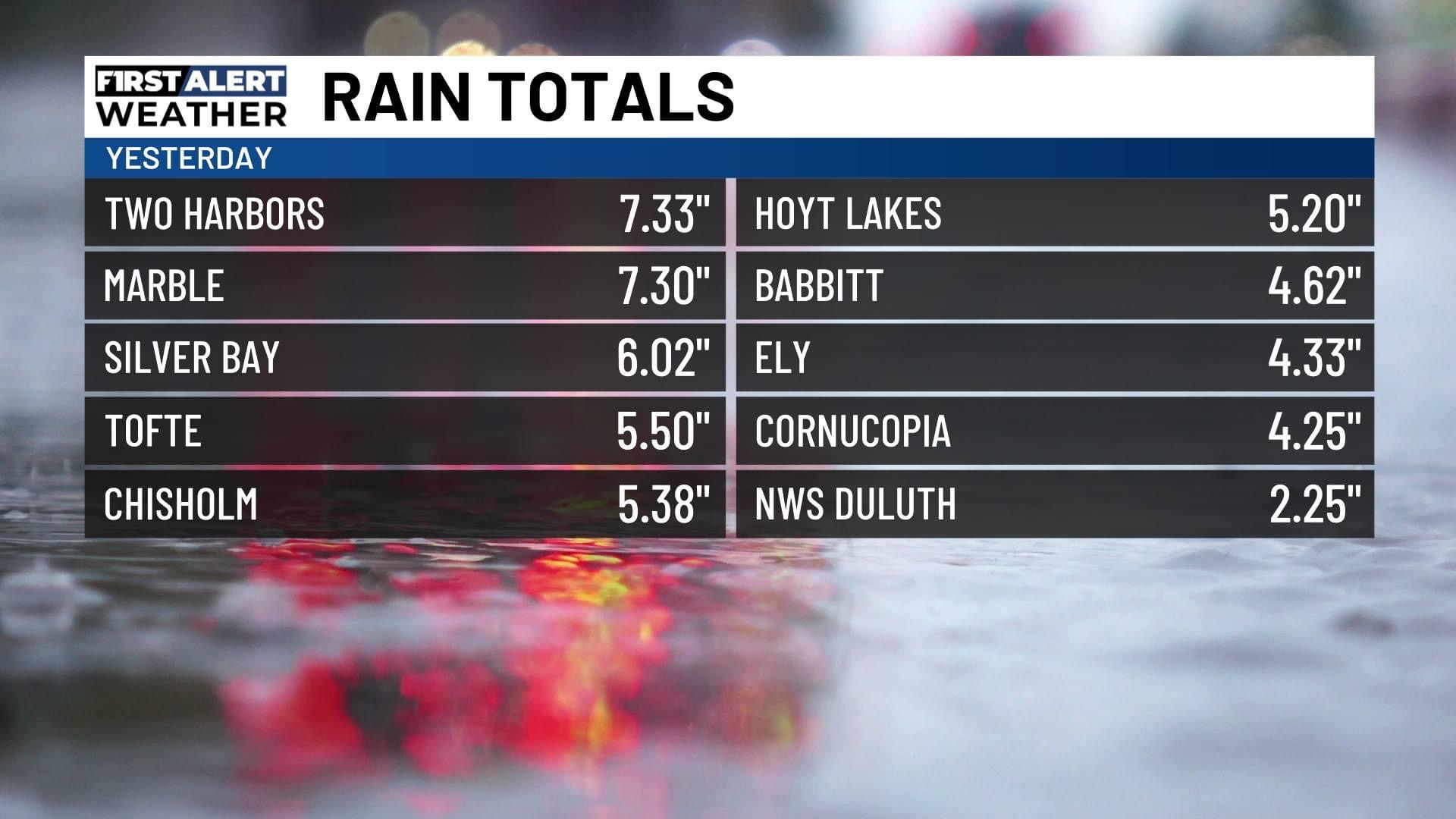
Point has a high of 70 today. Clouds should build in as the day goes on. Temps should drop into the 40s away from the UHI tonight. Monthly rainfall sits at 7.27”
-
High of 76 yesterday 1.12” of rain overnight.
-
Late June 2024 MN/WI/IA Flooding Event
OrdIowPitMsp replied to Geoboy645's topic in Lakes/Ohio Valley
-
Even with persistent NW flow we overachieved up to 81 today under the full June sun.
-
81/48 and feeling good.
-
This year *so far* has been significantly better in terms of smoke. Dews crashed from the upper 60s to the low 50s under mostly cloudy skies this morning. Great day to be working outside.
-
2024 Short/Medium Range Severe Weather Discussion
OrdIowPitMsp replied to Chicago Storm's topic in Lakes/Ohio Valley
Storm fail here last night, cap wouldn’t break. Didn’t see any precipitation. -
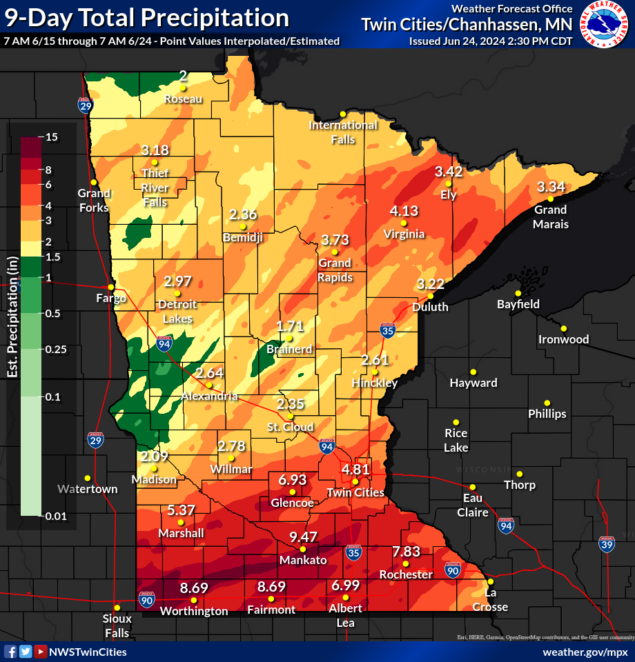
Late June 2024 MN/WI/IA Flooding Event
OrdIowPitMsp replied to Geoboy645's topic in Lakes/Ohio Valley
Article on the dam failure near Mankato. Flash flood watch here for expected storm development this afternoon. https://m.startribune.com/dam-near-mankato-in-danger-of-imminent-failure/600375733/ -
Beautiful precipitation minima centered right over mby. Enough to keep things healthy and green but no urban flooding.
-
Late June 2024 MN/WI/IA Flooding Event
OrdIowPitMsp replied to Geoboy645's topic in Lakes/Ohio Valley
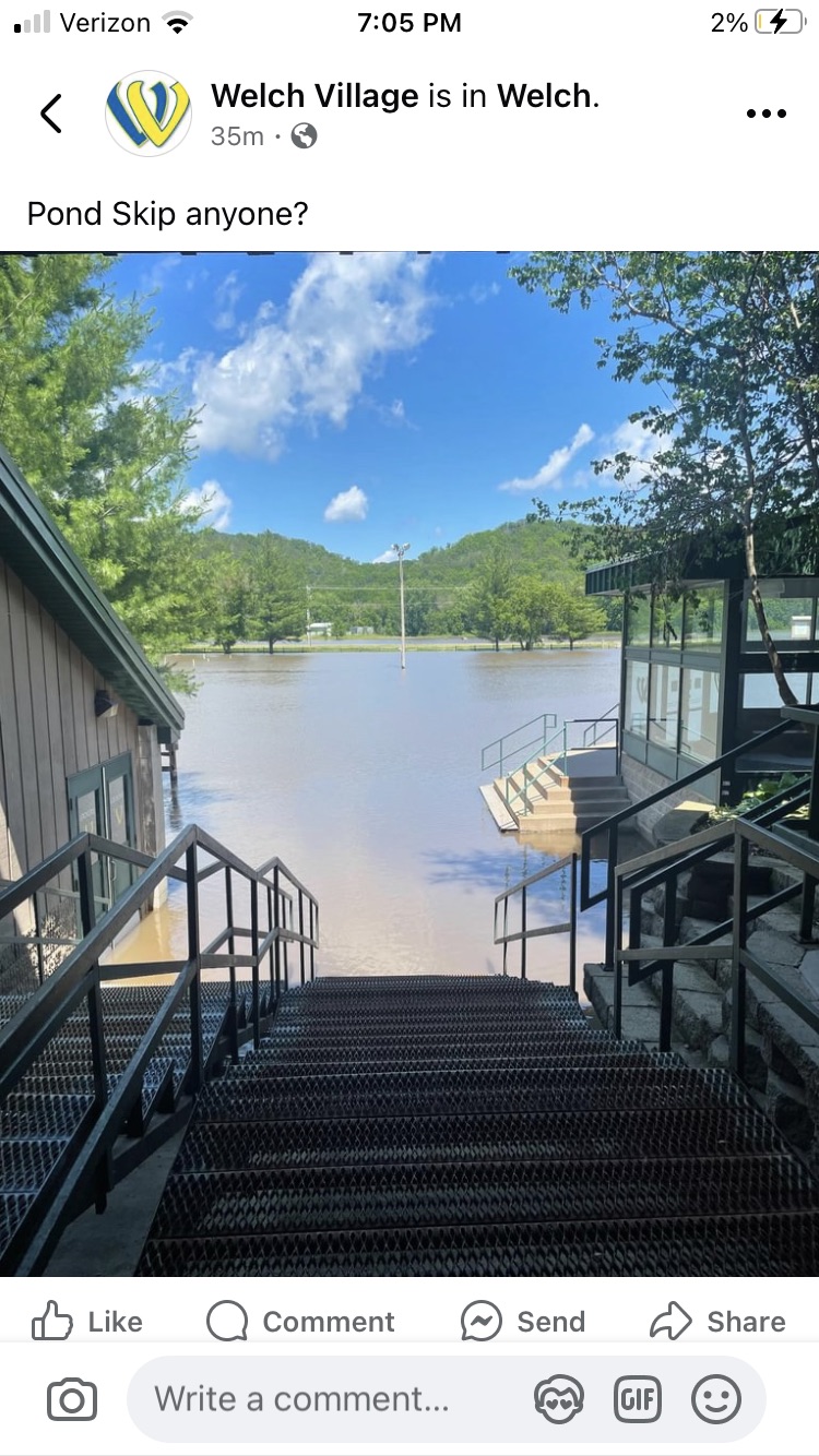
Hopefully there isn’t much infrastructure damage at my local ski hill. The Cannon River crested today in Welch Minnesota at 14.3’ with the record holding at 15.1’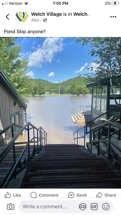
-
Another 0.64” in Minneapolis today. Next batch of rain about to move into Bayfield.
-
56 with drizzle/fog/mist. Having a lovely lunch on Madeline Island before heading over to Big Bay State Park for a hike.
-
Late June 2024 MN/WI/IA Flooding Event
OrdIowPitMsp replied to Geoboy645's topic in Lakes/Ohio Valley
0.63” overnight in Minneapolis. -
Late June 2024 MN/WI/IA Flooding Event
OrdIowPitMsp replied to Geoboy645's topic in Lakes/Ohio Valley
So far the twin cities have avoided almost all the rain as the training storms setup just south. Sun is even coming out here in Bayfield. -
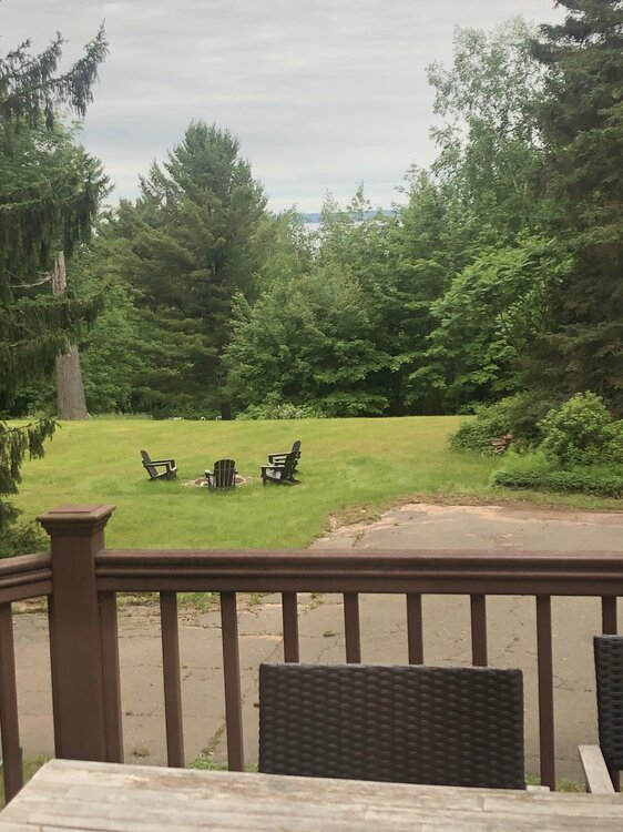
As forecast it’s a gloomy morning in Bayfield WI. Doesn’t take much away from the beauty of this area though. Lake Superior and Madeline Island are peaking through the trees from the back windows of our rental cabin. High of 58 today and tomorrow.
-
64/52 under thickening overcast. Perfect autumn day.
-
Late June 2024 MN/WI/IA Flooding Event
OrdIowPitMsp replied to Geoboy645's topic in Lakes/Ohio Valley
Relentless.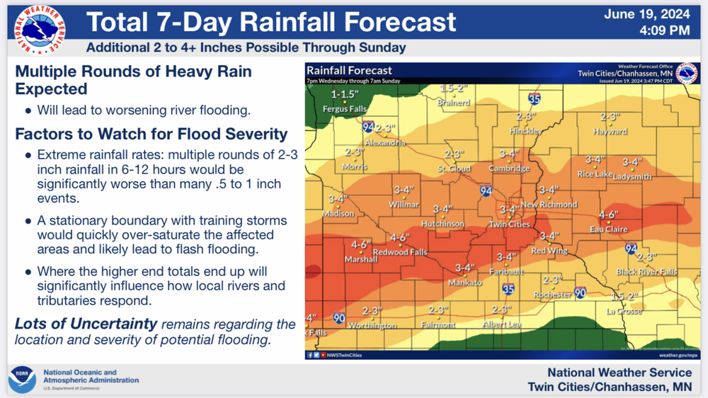
-
Late June 2024 MN/WI/IA Flooding Event
OrdIowPitMsp replied to Geoboy645's topic in Lakes/Ohio Valley
@Brian Dany idea where this TH report was taken.
-
Partly cloudy with temps in the upper 60s currently. We only picked up 0.35” of rain last night, the storms really blew up overhead and dumped a lot more rain just to the east. After dews in the 70s yesterday having them drop into the low 50s is great.
-
Late June 2024 MN/WI/IA Flooding Event
OrdIowPitMsp replied to Geoboy645's topic in Lakes/Ohio Valley
I rented a cabin in Bayfield WI, Thursday-Sunday. Looks like a chilly and wet weekend unfortunately.