Thinksnow18
-
Posts
4,144 -
Joined
-
Last visited
Content Type
Profiles
Blogs
Forums
American Weather
Media Demo
Store
Gallery
Posts posted by Thinksnow18
-
-
12z GFS fresh out...shows the same transformation all the other models are...i believe you're going to see a very different write up around 4pm today from the NWS
-
 1
1
-
-
-
-
I've begun to notice a trend that I think we're all going to like. The indices have not looked good recently and we've managed to stay average to slightly below average. The mid and long range has wanted to warm us up it seems 7 to 10 days out for about the last 2 week's. That signal is gone again. It now appears December will finish colder than normal with several opportunities for snow via synoptic and mesoscale. The Euro mid range was showing a PV split towards the Christmas time frame which would only enhance our chances going forward. Bottom line is when the indices do begin to go in the direction we like and we get an inevitable beat down of the PV I think January and February could be special.
-
 1
1
-
-
4 hours ago, wolfie09 said:
Yes they have come to a better consensus on a track. It appears it will be a track through Pennsylvania which may have the southern tier mix while the low goes by. All in all looking like a 3 to 5 for all...and the signal for LES looks good like BW pointed out.
-
 1
1
-
 1
1
-
-
-
The NWS is not at all impressed with Saturday-Sunday especially at lower elevations..and they consider Monday night-Tues an open wave...huh.
-
-
-
2 minutes ago, wolfie09 said:
But definitely came further NW with the precip shield...i believe yesterday's 12z was complete whiff SE...also it shows a shortwave (Alberta clipper) for Wednesday that would bring some lake snows NE of the lakes for a bit. Too early for anything worthy, however if this run is like the 00z there were several Clippers giving is chances.
-
 1
1
-
-
15 minutes ago, wolfie09 said:
Comes through here much weaker and as all snow...in fact I figure the GFS will come around on Monday night-Tuesday's little storm and a lot if what's being forecast looks to be white up until Christmas. Quite the change from about 1 week ago when it was cutter after cutter after cutter.
-
 1
1
-
-
-
20 minutes ago, rochesterdave said:
The models do great with placement but they still struggle with p-type. You get a storm, driving over 1” qpf, on the cusp, ya better stay alert. Elevation thing probably. But the big players are there.
If you look at the models the Canadian high pressure is over Minnesota, not too far to our west. Once the winds switch to NW later Saturday I can see a more powerful low being able to tap into that airmass and changing every thing to snow
-
-
The 00z high res euro is still maintaining its southern trajectory, but did nudge ever so slightly NW from the 12z yesterday.
-
3 minutes ago, DeltaT13 said:
Damn, as you obviously know that street ends (or starts) at doebler drive. Pretty crazy, my brother graduated in 94 so you may have known him.
Lmao more than likely!
-
6 minutes ago, DeltaT13 said:
Spent the first 18 years of my life on Doebler Drive. It was a very nice town to grow up in, aside from the lack of lake effect snow, lol.
grew up on Wurlitzer drive. Graduated in 93
-
3 minutes ago, WNash said:
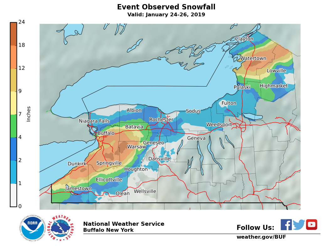
This was the storm. It was quite a bit worse than I thought in North Buffalo/Northtowns.

There was a huge cutoff NW of the airport. It really missed the area hit hardest in November 2000 and October 2006.
 …ERIE COUNTY…

     Colden 2.4 ENE           23.5
     Boston 2.5 NE            22.3
       Colden 1 W             21.6
   North Boston 4 ESE         21.3
    Buffalo Airport           20.0
   Cheektowaga 2.7 NE         20.0
     Boston 1.5 NE            18.8
  East Aurora 2.7 SSE         18.6
      Eden 1.4 SSE            16.7
          Wales               16.6
    West Seneca 0.4 E         15.5
  East Aurora 0.1 ENE         15.1
   West Seneca 2.3 NW         15.0
   Williamsville 2.7 E        15.0
Clarence Center 0.2 ESE       14.5
      Elma 2.7 WSW            14.2
  West Seneca 1.6 WNW         13.7
    Springville 5 NE          13.7
      Buffalo 3 SE            13.5
  East Aurora 1.0 ESE         13.5
    Hamburg 0.4 WSW           13.2
   Elma Center 0.7 SE         12.8
     Marilla 3 SSW            12.2
 Clarence Center 0.9 N        10.5
    Glenwood 1.5 SE           10.0
      Akron 0.9 NE             9.6
   Cheektowaga 2.4 NW          8.0
    Kenmore 0.3 ESE            7.5
  East Aurora 3.4 NNE          7.5
    Blasdell 1.5 SSW           5.6
     Kenmore 0.8 NW            3.3
    Tonawanda 3.1 NE           3.0
    Amherst 5.4 NNE            1.9
   Tonawanda 1.5 NNE           1.0
I will fight that Williamsville number all day long...if you look at the brown spot right by the and just north of the 90 is east Williamsville...and that is 18 to 24 inches.
-
20 minutes ago, wolfie09 said:
Yes unfortunately the models are not in our favor over the next 2 week's.
-
46 minutes ago, DeltaT13 said:
Amen, I grew up in North Tonawanda. It was brutal always being just a handful of miles away from pure insanity. The Christmas week storm from 2001 was particularly rough to watch from the side lines (and we even got 2 feet or so, just nowhere near what Buffalo got). Fortunately, for most people thats a huge selling point to living in the North Towns, most people hate snow.
Where'd you grow up in NT?
-
1 minute ago, WNash said:
The sun has come out at north campus. It took about 30 mins for the band to transit. There was a lot of wind, so it's hard to eyeball amounts, but it looks not more than an inch. So three inches for the whole event... in line with Buffalo NWS's low-end 10% probability. It's hard as hell to get sustained LES from downtown to the north.
We had a good hit this past January when we received 65" at the Airport and almost 30" during the one event...( yes KBUF was just under 2 feet but I'm sticking by my measurement) so it's possible and as BW mentioned earlier all models look good for some more LES next week.
-
No I'm stoked trust me. I wish this was stuck for 5 hours right where it's at.
-
 1
1
-
-
-


.thumb.png.6421dc25e0c1b9c9bcc8c3067204c48e.png)
.thumb.png.f2e8a318ab303cfbbf06b3d0d10686fb.png)
.thumb.png.91cf662831c7f3e5d2d27e4b52450056.png)

.thumb.png.6692f05fb34e0ca612def79c18bcd236.png)
.thumb.png.e80a6d359ddf512d39fb2f2e6c91bd31.png)
.thumb.png.d50cda83bbe0ad08394c5d905091a939.png)
.thumb.png.29c76d70d59a1b16503f56dda8672cc7.png)


Upstate/Eastern New York
in Upstate New York/Pennsylvania
Posted
Yet somehow it's not reflecting in the ops runs...nor forecast temps.