

Thinksnow18
-
Posts
4,144 -
Joined
-
Last visited
Content Type
Profiles
Blogs
Forums
American Weather
Media Demo
Store
Gallery
Posts posted by Thinksnow18
-
-
5 hours ago, wolfie09 said:
Euro still has a nice size snowstorm Tuesday night/Wednesday..
Saturday system is a little to warm for CNY, few/several inches for wny depending on temps..
I'm beginning to think the euro is correct...it was first to sniff out the low for tomorrow going south of us and the the GFS caved.
-
1 minute ago, BuffaloWeather said:
Saturdays event looks pretty minor to me. 1-4" across WNY.

Minor is the new major when it comes to WNY snowfall...yes I have sold my soul...
-
 1
1
-
 2
2
-
-
8 minutes ago, TugHillMatt said:
NAM is coming out looking good for many of us in Western and Central NY. Hopefully the GFS follows.
Still thinking this is an area wide 3 to 6. 3 towards southern tier and 4 to 6 northern Erie over to roch
-
1 minute ago, wolfie09 said:
The preference is to be between the 12Z GFS/12Z ECMWF but with a
slightly westward track of their surface lows given ensemble mean
placement. Due to poor ensemble agreement and poor run to run
consistency in the guidance, confidence is below average.
So we're within 48 hours and low confidence...
-
1
-
-
Yeah those are great points wolfie. Just wondering what they are seeing that they call for precip type issues
-
The ensembles already show that western trough moving east at the end of that time frame, ala last year almost to a T. More concerning is the NWS just basically stated in their AFD that it will primarily rain Saturday and not switch over until late evening to over night...which model actually shows that scenario I ask?
-
10 minutes ago, rochesterdave said:
CMC came in strong. Finger lakes look good for a few inches- if that. This pattern...
2, 3, 4 or 5 inches is better than the grass and mud I have all over my damn house right now due to this God awful pattern...ill take the lake effect opportunity mon thru Wed
-
2
-
-
28 minutes ago, wolfie09 said:
Though it is hard to trust a model that looked like this last run..
Yeah the euro seems like it partied with cousin Eddie and also has a plastic plate in its head...
-
2
-
-
5 minutes ago, wolfie09 said:
Nam/gfs have this as a 1"-3" Snowfall with a loli of 4" or so..
Euro also has 4"-6" in and around NYC/LI , no other model has near that lol
I guess we'll see..
I'm not buying into accums yet...the 12z has the entire low staying in central pa never getting into NY and it still shows 1 to 3...not buying that at all.
-
I actually like this system for the Rochester area. I can see a way where, with enhancement from the lake, that roch ends up in th 5 to 8 or 6 to 10 range. The system is trending colder and that's a good scenario for you with NE then northerly winds.
-
5 minutes ago, rochesterdave said:
Last nights euro was pretty interesting for the finger lakes especially. I’d include the BUF and ROC suburbs in that interest. We’re talking a 3-6” thing, so don’t get too excited. But I can see that happening.
Hey 3 to 6 and then a couple more shortwaves and colder temps until late next week will at least make it resemble winter out here.
-
1
-
-
8 minutes ago, vortmax said:
Can anyone tell me when a primary 997 LP passed to our west and stayed all snow in WNY w/no secondary coastal?
Actually it's diving out of Canada and stays north...either way with marginally cold air around that would be a mix or rain changing to snow.
-
9 minutes ago, wolfie09 said:
GEFS pops the secondary right over NJ..
.png.c034c2c38491c9dc9c211ba183e71e1a.png)
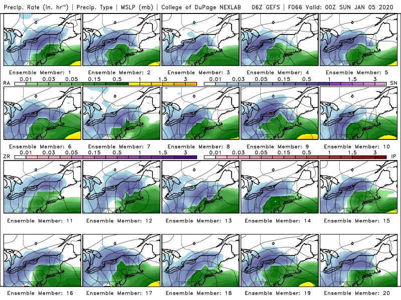
Just about all of those members are good hits for western and central NY
-
4 hours ago, Syrmax said:
Joe Bastardee is tweeting this.
I love a good clown map.

Yeah bastardi is to weather as PT Barnum was to the circus. The NWS AFD is discussing moderate (think 3 to 6?) Accums for Saturday from buffalo to roch and North...with their most likely outcome 1 to 3 but state that if the cooler ensembles verify could be more due to enough QPF.
-
25 minutes ago, TugHillMatt said:
0Z NAM coming in way north now compared to 18Z...is this a situation where the 0Z and 12Z runs wrestle with the 06Z and 18Z?
Funny, the New England board has 10 pages devoted to just this weekend's event....while in here it's crickets.
 But much of theirs is their typical bantering and putting each other down.
If we can get the canadian high to become a little stronger and force the front further south and east Saturday could be a much different outcome
-
2 hours ago, BuffaloWeather said:
NWS isn't mentioning Saturdays storm at all, just calling it plain rain entire duration.
Yeah I find that their longer range has not been very up to date. I'm expecting the 4pm update or tomorrow AFD to be different...also all models show what could be a decent clipper lake effect event Monday night to Wednesday.
-
1
-
-
2 minutes ago, wolfie09 said:
Gfs looks pretty good Sunday through Wednesday with several clipper systems, bouts of synoptic and lake effect snow..
Yeah I'm not sure why you guys are jumping ship so early...tomorrow is January 1st...there are 60 or so good days of winter left if not more. Relax.
-
1
-
-
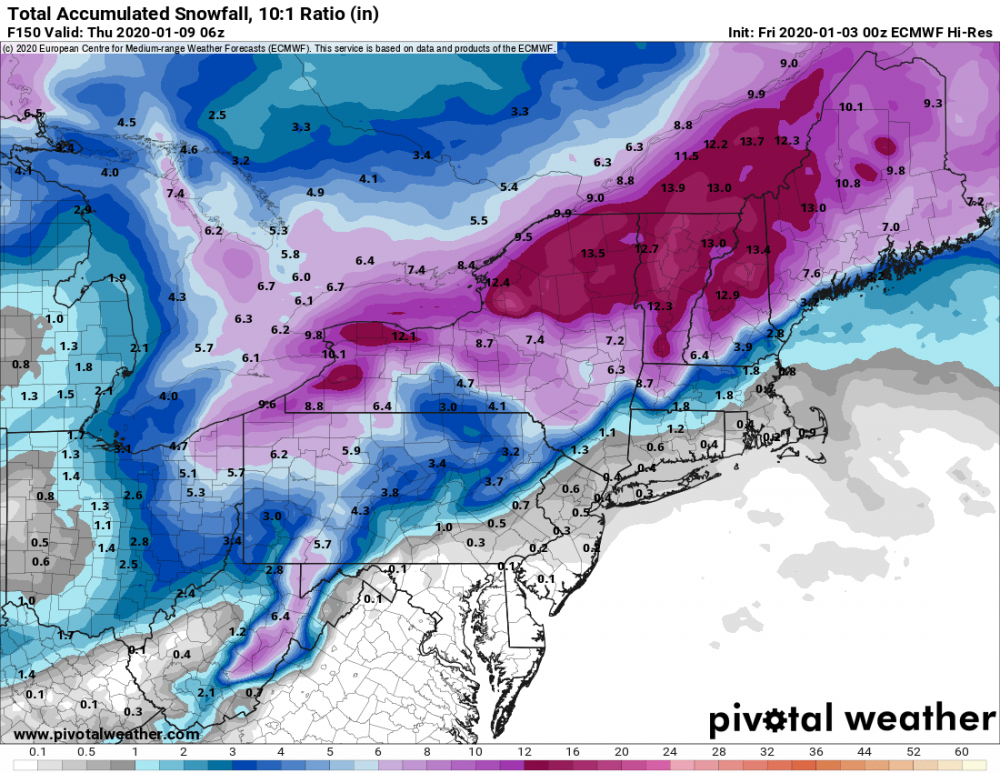
Im beginning to think the above model run is where we see the 18z GFS trying to get to as well...it is Tuesday so this storm is only 5 days away...
-
5 minutes ago, CNY-LES FREAK said:
We can't even get snow to fall with the dam front itself, as that to is going to be rain!
Sent from my SM-G970U using Tapatalk
Freak there's a new thread...
-
4 minutes ago, WNash said:
It’s a mix up here near the Buffalo/Snyder/Cleveland Hill line. Accumulating a little bit, though. I think this will show as a trace, unless the airport gets a bigger burst.
Snowing and sticking decently in Williamsville ground has a light wire slushy coating
-
2 minutes ago, SouthBuffaloSteve said:
Special Weather Statement
National Weather Service Buffalo NY
1001 AM EST Tue Dec 31 2019
...BURST OF SNOW AND GUSTY WINDS WITH LOW VISIBILITY EXPECTED
THIS AFTERNOON...
A burst of moderate to heavy snow is expected by early this
afternoon over western New York and by mid to late afternoon
across the Genesee valley. Expect sharply reduced visibility
below a half mile during heavier snow showers, along with wind
gusts over 30 mph. The worst conditions are expected over the
Niagara Frontier and western Southern Tier, including the Buffalo
metro, between 11 AM and 2 PM, then over the Genesee valley,
including the Rochester metro, between 1 PM and 4 PM.
It is also possible snow squall warnings may be needed later
today in some areas as this snow moves through. Expect the snow
to transition to lake effect snow showers by early this evening.
.At the current 37 to 38 degrees I doubt that's all snow when it rolls through
-
17 minutes ago, SouthBuffaloSteve said:
Seeing some nice lake enhancement with the precip blob over Southern Ontario. Actually a pretty good line firing up heading into Niagara County right now. Think this is going to be our only way to see any snow here today is to hope for some bursts like that to work through...

.Must be quite a bit of virga going on in the leading edge of the precip shield as its neither raining or snowing here.
-
4 hours ago, BuffaloWeather said:
92 pages!
New thread for the new year!
Models looked better for snowfall overnight...gfs 6z has the clipper back for late in the weekend with plenty of cold around COULD be a chance for some appreciable snows with lake effect setting up during that time.
-
22 minutes ago, BuffaloWeather said:
hybrid, better moisture and low placement there than here and slightly colder temps.
Same old story. The colder air 400 miles to our west will modify enough to keep us from anything substantial.


Upstate/Eastern New York
in Upstate New York/Pennsylvania
Posted
Was just going to mention that...but...didnt the euro pick up on this being just a low end wave of low pressure 2 days ago??? If that's right then the tuesd Wed storm might be the euro FTW