

KoalaBeer
-
Posts
606 -
Joined
-
Last visited
Content Type
Profiles
Blogs
Forums
American Weather
Media Demo
Store
Gallery
Posts posted by KoalaBeer
-
-
11 minutes ago, dendrite said:
Glad I don't grow corn.
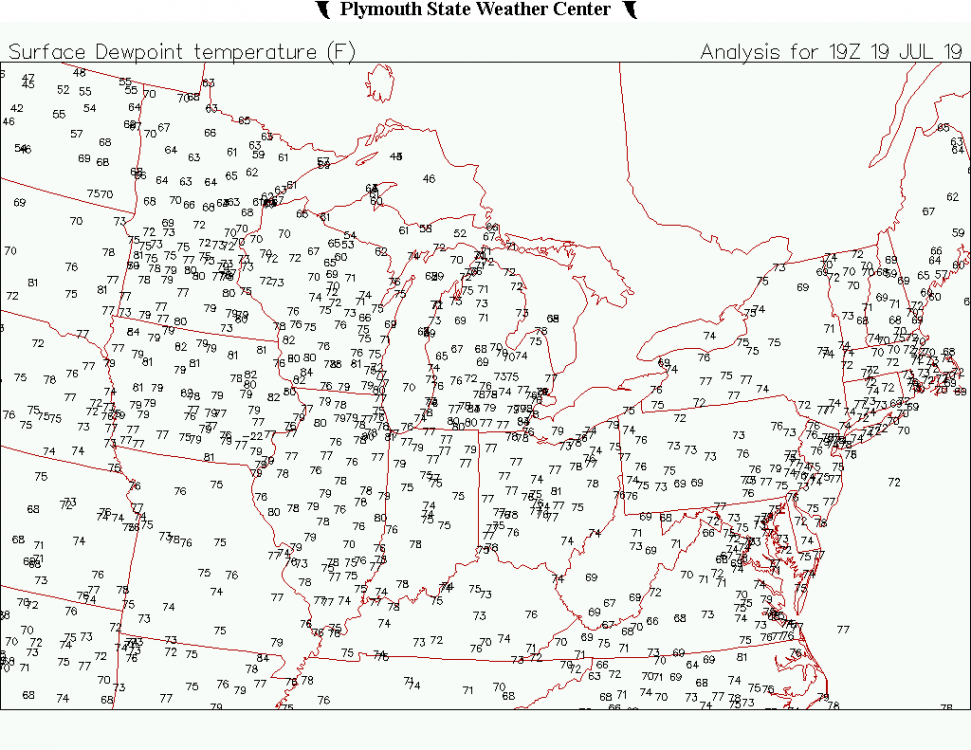
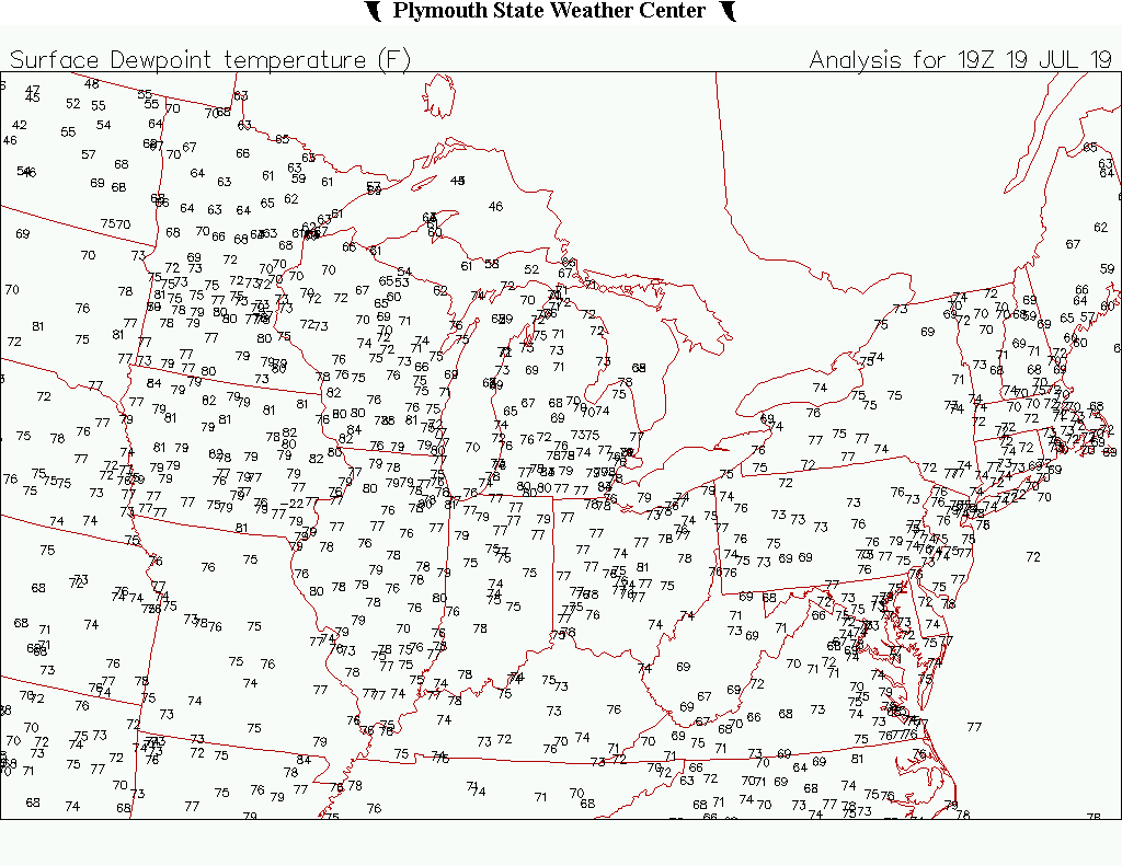
That 84 in NW Iowa
 . Looks like that station was 90/86 for a reading if it's to be believed.
https://mesowest.utah.edu/cgi-bin/droman/meso_base_dyn.cgi?stn=KSHL&unit=0&timetype=LOCAL
Time
(CDT)2.0m Temperature
° F2.0m Dew Point
° F2.0m Wet bulb temperature
° F2.0m Relative Humidity
%10.0m Wind Speed
mph10.0m Wind Gust
mph10.0m Wind Direction Pressure
inAltimeter
inWeather conditions Visibility
milesCeiling
feetQuality
Control13:55 89.6 84.2 85.4 84 17.3 28.8 SSW 28.18 29.67 Clear 10.00 OK 13:35 89.6 84.2 85.4 84 20.7 27.6 S 28.17 29.66 Clear 10.00 OK 13:15 89.6 86.0 86.8 89 15.0 24.2 S 28.16 29.65 Clear 10.00 OK -
KBED at 90/72 with KLWM AT 84/70 man has that site been running hot lately.
-
NWS BOX throwing out the D word in their latest discussion. SPC still doesn't have us highlighted at all yet.
Friday through Sunday ...

Hot and humid. H85 temperatures around +20-22C, H7 around +10-12C.
But concern. Steep mid-level lapse rates around Saturday, a lot of
low-level instability. Shear vectors and orientation that suggest
that if something were to become organized over Michigan within the
region of steep mid level lapse rates and advect that perhaps we
could see MCS / derecho activity Saturday and Sunday. Initial
thinking, but nothing set in stone. Initial indications per 17.12z
NAM and 17.0z EC, but not much indication in SREF / GFS. It would
subsequently impact 2m temperature with cloud cover altering the
heat and humidity forecast. Typically when we get the heat and
humidity where highs alone approach triple digits do we see via
climatology MCS / derecho events. Continued forecast of mid to
upper 90 highs, some locations at or just slightly above 100
with dewpoints in the low 70s as boundary layer moisture is
trapped beneath the cap, fueled by S flow, yielding heat indices
around the triple digits, for some locations at or above 110F.
-
 1
1
-
-
Looking at radar trends I’m a little concerned about training storms moving in towards Worcester.
-
Just now, sbos_wx said:
Hah, maybe I should have taken a closer look, my bad
Hah no worries, it looked like it was tightening up quick to me! Stuff moving towards me in Northern Essex is looking pretty lackluster right now. Oh well

-
2 minutes ago, sbos_wx said:
That's more broad though, the other is tighter
TOR warning for the cell going into W Mass just got issued.
-
1
-
-
Just now, sbos_wx said:
There is rotation W of Hopkinton... If it tightens up any more, we might see a TOR warning
Same with this one W of Pittsfield.

-
13 minutes ago, weatherwiz said:
I’m thinking that dews end up mixing down into the mid 60’s.
The high clouds may halt some areas getting to 100 or 101. There are even some hints we could see convection during the day
I don't know....that citrus looking thing in the sky might push us to 100.
")
But for real, I'm going to take the under on 100. If I recall correctly we only tickled 100 up here in the Merrimack Valley during last years heat wave and that looked more impressive then this in my opinion.
-
Is the map of the US on NWS homepage to get to particular WFOs not clickable for anyone else in here?Right as I comment it starts working for me again...Also looks like remnants of Barry are causing more problems in Arkansas today then it did along the most of the gulf coast. Who would've thought.
-
22 minutes ago, CoastalWx said:
Wicked nasty rains at LWM
.70 inches in 15 minutes. Can confirm, was only about a mile from LWM airport when it came through.
https://mesowest.utah.edu/cgi-bin/droman/meso_base_dyn.cgi?stn=KLWM&unit=0&timetype=GMT
-
I seriously don't trust a thing he says and can't believe some people give him the time of day. Compares yesterday to 1953 then still pats himself on the back with this tweet...
-
 1
1
-
-
3 minutes ago, STILL N OF PIKE said:
Bunch of good storms again
Yup! Looks like round two for us here although not expecting anything as strong as earlier this afternoon.
-
2 minutes ago, Modfan said:
Nice storm just NW of Worcester; any rotation with it?
Nope. The shear is very Uni-Directional today. Should be a good hailer though. I won't be surprised if it that cell slips just west of Worcester as well.
-
14 minutes ago, Dr. Dews said:
Continuous thunder here, vivid lightning
Nice. You are in the Lowell area right?
Right on cue the cells moving into Boston Metro and North Shore just got warned.
-
Pretty intense here in North Andover right now as well. Not much lightning/thunder but got a good burst of hail up to about 3/4 of an inch. This definitely beats yesterday for me at least in this area.
I won’t be surprised if they warn that cell moving into Burlington MA right about now.
-
1
-
-
One heck of a fireworks show north of me right now.

-
2
-
-
Snowing up in the high country of CO again. Snagged this from the webcam at Arapahoe Basin this evening which is still open for skiing during weekends.

-
1
-
1
-
-
Pea sized hail and I'd estimate about 35mph winds as a cell moved through in North Andover at about 3:05 PM.
-
1
-
-
51 and heavy rain here in North Andover. Gross out.
-
9 minutes ago, F-5 said:
-
-
Possible visual on the Tornado. Looks massive.
-
-
I believe this is the Tornado by Akron earlier.
-
3
-


Big New England heat 7/19-21
in New England
Posted
From an WMUR article...Dr.Dews? I must admit I am a little bummed we aren’t going to see any good convection out of this. Oh well, another day at the pool sipping on IPAS then.
HAMPTON, N.H. —
Extreme heat draws crowds to the Seacoast, and people packed Hampton Beach on Saturday for relief.
“This is my favorite time of the year,” said Seth Hinson. “I hate the winter. I can't stand it. I wish it was 100 every day.”