

Henry's Weather
-
Posts
1,729 -
Joined
-
Last visited
Content Type
Profiles
Blogs
Forums
American Weather
Media Demo
Store
Gallery
Everything posted by Henry's Weather
-
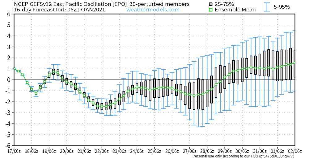
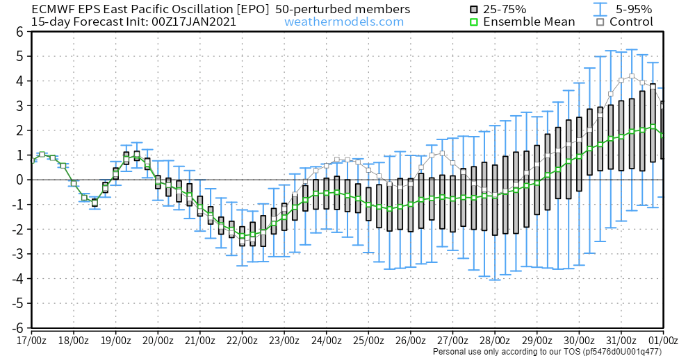
At least it seems like we'll get some cold air soon, which is definitely an improvement. Looks like the -EPO shot didn't disappear as we approached it in time. 4 days out, and solid -2 to -2.5 sigma values still forecast, and seems to stay at least slightly negative through almost the end of January. Cross-ensemble package agreement here.
-
My guess is that we should see more misses than hits for the next couple weeks but if this becomes n-stream dominated and we cut out that stream of s/ws from the SW, the upside increases for a nice miller B event into February. It's patterns like this that make me wish models only went out 5 days. Constant barrage of s/ws in a decent pattern, but many miss. Can be frustrating as a model-watcher. We'll probably get a decent hit with that anomalous NAO (though not as foolproof as a good pac, still positively correlated with snowy patterns) but the specifics aren't clear yet, of course.
-
I just wanna see flakes in the air and some snow on the ground at this point.
-
that forecast hr panel is not the best, I agree. Needs a slider
-
pivotalweather has it out much earlier than TT
-
Read my mind...
-
you're the guy who gave everyone weenie tags in the NYC thread the other day. i shit you not, ever single post i read was weenie tagged by you lol.
-
thought I noticed a flake or two this morning, but was pretty sure it was snow-deprivation hallucinations
-
Weenie miller b on the long-range gfs again. Not that I care or anything...you guys believe me, right? In all seriousness, I feel like I don't trust anything from the southern stream to not be total crap by the time it reaches us on the coast. These shortwaves traversing the country remind me of summer thunderstorms as they approach the coast.
-
Saw this today. We pray.
-
Incredible run, 2 shortwaves closing off south of LI and a third storm to follow. Shows the upside of the pattern one would think.
-
If we're exchanging the favorable PNA for a favorable EPO, what is an example of a pattern where those two are coexistent?
-
What's with H5 lows weakening as they reach the coast? I feel like I've seen that happen pretty frequently this year. A la nina thing?
-
Seems sufficiently north too
-
Potential analog?
-
Thank you, I always enjoy reading these.
-
Pretty cool synoptic setup at the end of gfs run. Not saying it'll happen obviously, but cool to see a powerful cut-off low traverse the continent and just sit south of ACK. Very cold storm too.
-
I'd think this dateline ridge would be more helpful for us than a weak-sauce PNA downstream of a raging Aleutian low
-
you could always hit the gym!
-
There are a serious number of ensembles that show sub-980 mb storms through the end of the run. Hopefully the age of the saggy isobars is coming to a close.
-
Talk of candlepin bowling in the general January thread... not a great sign I'd say
-
I've seen lots of peeps talking about a lack of baroclinicity. Can this be amended by a cold shot alone, or do we need more, like a bombing cyclone to tighten the pressure gradient?
-
On the GEFS, it seems about midmonth that the floodgates let loose for polar air. Definitely a bonkers pattern, and it's not perpetually at 384 hours. I don't give a shit, I'm all in. We'll get something good, one would think there's too many good things happening for things not to work out in some capacity.
-
Why can't this northern vort dig? Would the ridge need to be stronger?
-
If that southern vort gets out ahead faster on 1/12, is there still a chance to salvage this threat?


