
PowderBeard
-
Posts
2,027 -
Joined
-
Last visited
Content Type
Profiles
Blogs
Forums
American Weather
Media Demo
Store
Gallery
Everything posted by PowderBeard
-
Dec (Edit: Jan1/..2 ) multi-faceted ptype mess potential...
PowderBeard replied to Typhoon Tip's topic in New England
Yea, widespread sleet and glaze across Mass/CT. -
Dec (Edit: Jan1/..2 ) multi-faceted ptype mess potential...
PowderBeard replied to Typhoon Tip's topic in New England
Trying to remember reggie has not found a nut in a few years. Wouldn't even mind a sleetfest at this point. -
Dec (Edit: Jan1/..2 ) multi-faceted ptype mess potential...
PowderBeard replied to Typhoon Tip's topic in New England
Looking similar through 63. -
Other than the NAM 3km and its typical "throw all the moisture" deal on a NW flow, other models are really limiting the moisture for Mon/Tues. I could see some 2-4" spots from K north.
-
Christmas Eve/Day Annual Scrooger Event
PowderBeard replied to Baroclinic Zone's topic in New England
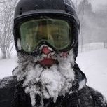
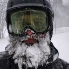
More pics on FB.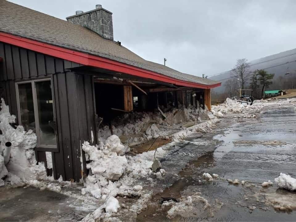
-
Christmas Eve/Day Annual Scrooger Event
PowderBeard replied to Baroclinic Zone's topic in New England
Disaster at Belleayre ski area in NY. 6.5" of rain this morning. Part of a trail broke lose and slid down into the lodge. Looking at the pics on FB it looks like 3-4'of snow and mud in the lodge, most of the windows are out, etc. -
Christmas Eve/Day Annual Scrooger Event
PowderBeard replied to Baroclinic Zone's topic in New England
Seriously. Likely going to be in Haddam tomorrow. Christmas by fire. -
Christmas Eve/Day Annual Scrooger Event
PowderBeard replied to Baroclinic Zone's topic in New England
I have been watering mine in the evening so it's locked up.- 993 replies
-
- 11
-

-

-
Christmas Eve/Day Annual Scrooger Event
PowderBeard replied to Baroclinic Zone's topic in New England
The shear surprised me. Wasn't there event earlier this summer/fall with low CAPE and high shear that surprised? It's escaping me. -
Damn, yea it looked it on the webcam. Line for Sunbowl was heading up Wingding. Looks like a lot of folks are out there today before the melt. Heard Huntah is a complete ___show too.
-
Christmas Eve/Day Annual Scrooger Event
PowderBeard replied to Baroclinic Zone's topic in New England
Everything I can find is NY related and gusts in the 30s. There were bigger issues. https://www.weather.gov/ctp/Jan1996Flooding -
Yea let's dodge New Year's without power and Chinese food. Approaching 50* high above and mid-low 20s at the surface. Damn.
-
Christmas Eve/Day Annual Scrooger Event
PowderBeard replied to Baroclinic Zone's topic in New England
Yea the 12z HRRR at the end hinted at that as well, especially across CT and up Hippy Valley. -
Meanwhile. I found some size 15 boots. Can you tell we have a toddler in the house? Just noticed the dog bowls in background. Ordered December 7th, 2nd day air, finally arrived today. She can actually walk in them versus the smallest I could previously find in 16.5
-
They have an updated system, tons of water, and a base at 2000'. As I mentioned earlier, there were years they were running top-to-bottom before Sunday River and Killington in October/early November under Peaks. I would bet there will be some condos for sale at both after this year and Cannon will have a big jump in season pass sales. Absolutely shame, aside from DJ's at Cannon, Wildcat has the best lift-served terrain in NH.
-
Christmas Eve/Day Annual Scrooger Event
PowderBeard replied to Baroclinic Zone's topic in New England
No one bothers heading out if its blowing 15mph straight from the north or south. There are 4-5 footers with 25-30 mph. Christmas will probably look something like this. What a difference a week makes. Replace weenie kuchera maps with weenie wind maps. -
Christmas Eve/Day Annual Scrooger Event
PowderBeard replied to Baroclinic Zone's topic in New England
Yea I would be worried about SVT and NY. Throw 2" of rain on feet of snow, streets will be flooded out. The Susquehanna around Binghamton and the West River of SVT will be in trouble. Luckily there should not be much ice up there yet. Deerfield, Westfield, and Housie should be pretty high as well. -
Christmas Eve/Day Annual Scrooger Event
PowderBeard replied to Baroclinic Zone's topic in New England
- 993 replies
-
- 13
-
-
Right? They haven't even opened the Flyer or any woods this year. MRG has only had the Practice Slope open. No Castlerock at Sugarbush or Madonna at Smuggs. When is the last time that happened in a December? Wildcat is essentially one way down from the summit. They all typically get close to 100% open for a weekend or two before a melt-down at the end of the month.
-
2" new. 20.25" for the season.
-
A nice 2". I wish we could get one of these winter mood deals a week.
-
Afternoon football and evening skiing.
-
Very nice moderate snow. Feels like winter.
-
There is one stump towards skier's left on Jug that gets me and made me a Marker binding fan. Twice I smoked it, ski got stuck, and released. And that was on a front DIN of 11, lucky both times. I ski on the right side now lol.
-
They have been all over the place. First it was 2', then 3', then 4', then 30", then 38", now back to 4', depends which of their social media pages you look at. Either way, an awesome start. The 40+ at Okemo was too much for them. Lines were epically long with only 1 lift running most of Thursday, lots of pissed off pass holders and ticket buyers.

