

WesternFringe
-
Posts
988 -
Joined
-
Last visited
Content Type
Profiles
Blogs
Forums
American Weather
Media Demo
Store
Gallery
Posts posted by WesternFringe
-
-
9 minutes ago, pazzo83 said:
lol I lived in Staunton from 1991-2002 (and then 4 years in C'ville after that), but ok. In 1994 we got down to -15F in town, on a day that only barely got above zero. 1996 had a similar cold snap. Night time temps in the teens were common from Dec - late Feb. Even this year's Christmas cold snap would've yielded below-zero temps in town years ago - instead it was right around zero.
Yeah, we got to -15 two or three years ago. Haven’t noticed any immediate warming trend. Been in this area longer than you. 1993 to present.
Not sure how to respond to how you know that this year’s cold snap would have been below zero years ago, but instead was right around zero. Those are some serious skills you have.
-
2 hours ago, psuhoffman said:
Your average low right now is about 20*. Ya I know that sounds crazy because it’s been forever since that was a typical night in winter but that’s about the 30 year mean for stations in the Shenandoah Valley area. In past periods it used to even be in the high teens this week! Even IAD avg low is 25! Don’t worry, it won’t be for long if this keeps up.
‘Shenandoah Valley Area’ is a large area to generalize. I live at 1550’ nnw of Staunton and we have had many nights below average temps this year. It has been plenty cold, just no precip to match.
-
20 minutes ago, pazzo83 said:
20-30 years ago, nighttime temps in the teens were routine there. Now with a pretty good airmass in mid Jan and optimal cooling conditions, you're stuck in the 20s. That translates for the urban areas that used to get into the 20s now stuck above freezing even overnight. It's a major problem (if you like snow).
Okay, mansplain my climo for me. We were 0 to 10 degrees recently for 3 nights in a row, with wind chills in the -20s and -30s.
Where were you all with ‘20-30 years ago, it was in the 30s-40s this time of year’ ??-
 1
1
-
-
1 hour ago, psuhoffman said:
Your average low right now is about 20*. Ya I know that sounds crazy because it’s been forever since that was a typical night in winter but that’s about the 30 year mean for stations in the Shenandoah Valley area. In past periods it used to even be in the high teens this week! Even IAD avg low is 25! Don’t worry, it won’t be for long if this keeps up.
Tonight is a low of 22. Plenty of cold but no precip. Tomorrow night’s low is 28, but no precip again. Cold isn’t my problem at the moment.

-
It’s cold right now. 34 dropping to 28 tonight here. Just can’t get precip plus cold.
-
Sleet and snow here in Augusta County. 32 degrees
-
5
-
-
26/24 cloudy here in NW Augusta County. Smells like snow outside.
-
2
-
-
1 hour ago, psuhoffman said:
You’re making a straw man argument. No one has said it can’t snow. As a matter I’d fact a few posts up in this thread I literally said it will still snow and we will still get snowy seasons.
But we are getting less. In the last 50 years DC has gone from averaging about 4 1”+ events per season to 2.5. They’ve gone from averaging about 18” to 14”. Their odds of a single digit snow season has doubled! Every metric has gone the same direction.
Maybe in 5 years we change cycles and start some epic run but none of us can predict that. I’m simply basing this on what’s actually happening recently and now.
But I don’t think you realize how big a hole were in. DC needs almost 20” this season just to avoid the last 7 years being the least snowy period ever! Let’s say DC ends this season with 10” and that’s optimistic and would be one of the best turn around for a season that started this way…then for DC to end a 10 year period back to its long term avg DC needs to avg 41” of snow the next 3 seasons! Even just to end 10 years back to the pathetic current lower avg (which wouldn’t even really refute my argument since the current 30 year avg is lower than the past) DC needs to avg 27” the next 3 seasons! I dunno man that seems like a huge hole to be expecting us to dig out. Seems more likely that at least for the near future the downward trend in snowfall continues. Even if DC gets 20” each of the next 3 years it will still end the 10 year period having lowered its snowfall average significantly under what was already a lowers avg from the last period.
But I don’t think you realize how big a hole were in. DC needs almost 20” this season just to avoid the last 7 years being the least snowy period ever!
I probably don’t realize how big the DC snow is because of the imby bias where it hasn’t been horrible except for one year. And the statistical analysis I ran said most of the variabilty is due to noise.
However, if it becomes the least snowy year ever, then the law of averages says it will snow a lot soon. Under my theory. Again, we shall see.
-
1 hour ago, mappy said:
for the realists out there... NAM snow depth
.thumb.png.ae3e45b7a0b3a460fe5d3fe016dff357.png)
I understand what you are saying about the end result and what is otg, but at this point I would pay to see inches of snow falling from the sky even if they are disappearing as they hit the ground!
-
6 minutes ago, Cobalt said:
This is a common fallacy. Around 10% of peer-reviewed papers discussing the future of our planet's climate in the 70s predicted cooling, meanwhile 62% predicted warming, and 28% had no stance. To be more relevant to this thread, you've mentioned record cold at local sites, but that has been over very short stretches. When just looking at the temperature departures for the past 2 winters across the CONUS, they skew pretty warm.
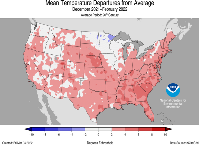
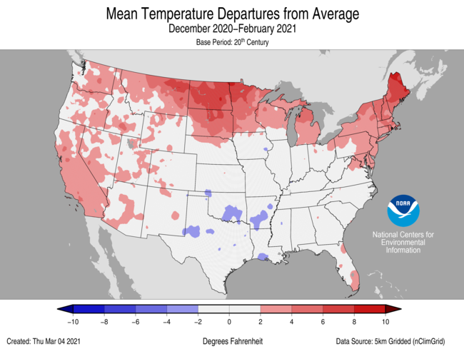
And yes, there were several record cold days or even weeks, notably with February 2021, and a bit less with the chilly January 2022. The issue is that one cold stretch or even month doesn't make a cold winter, and when those major cold patterns haven't aligned, we've defaulted to being much warmer than average.
This is obviously a small sample size but it was mainly meant to go over what you've said about the recent record cold. It's been mostly drowned out by warmer stretches taking up a majority of the rest of the winter, much like we're seeing now. Perhaps things will flip if we sustain a stretch of warmer ENSO years, but expecting cold and snowy seems to only work around 2-3 times per decade.
Good points. I think that same analysis could apply to years before and after 2009-10 and before some great storms in 2014 and 2016. Etc
No doubt we are in a bad luck stretch and folks are stressed. 3 Ninas in a row will do that to you. I just think recency bias makes people overly negative regarding our modern snowfall potential.
-
10 minutes ago, psuhoffman said:
It is warmer than it was 50/100/150 years ago. That’s not up for dispute. It’s just a fact. What’s disputable are 3 things.
1) How much of the cause is man (we don’t need to have that fight here it doesn’t matter to this discussion)2) how much is cyclical
3) if it’s cyclical when will the cycle reverse
But none of those things impacts my point. I’m not debating what snow climo will be 50 years from now. I’m debating what our snow climo is RIGHT NOW compared to the past. That’s more relevant because we base our expectations and forecasts on analogs and historical precedents. My point is right now we are in a warmer base state and it’s hurting our snow prospects right now compared to eras many of us use as the baseline for expectations.
You might be right that 20 years from now things have flipped and it’s getting colder. I don’t agree but I can’t prove that’s wrong. But why does that even matter to what I’m saying?
It matters because it seems that you and others are almost saying we can’t snow anymore. Thus the ‘perfect track in the coldest week of the year can’t even snow’ comments.
We just had near record cold, just no precip around. That’s merely called bad luck in my book.
I fundamentally disagree and think the law of averages means it will snow very well in the MA soon. It might be the end of this winter or the next or the next. I just don’t agree that bad luck in the last few years for some or many on this board (I had above climo last year) means that our immediate, medium, or long-term prospects for significant and healthy annual snow are doomed.
-
16 minutes ago, psuhoffman said:
Both those places have a colder climate. You can add a couple degrees and it would affect way less of their snow events. It might even help more than it hurts in their cases. Warming is causing increased snowfall in some places.
But our area a larger % of the snow comes with temps very close to 32. Adding a couple degrees is more likely to hurt us. Additionally we get snow from boundary waves not arctic waves or lake affect. Very different.
let’s simply state 2 facts.
1)It is getting warmer.
2) historically a lot of our snow fell with temps barely cold enough
Those two facts when accepted together make this pretty obvious.
What about the record setting cold in Texas and Oklahoma last year? Or close to record cold in Atlanta this year? They don’t have a colder climate than us.
In the next decade or two I think we will be approaching very close to historical averages. The pendulum swings. In the 1970s they were worried about a quickly approaching ice age because of the extreme cold. We shall see.
My parents who live nw of Atlanta have been seeing more snow than they used to a decade ago. We have had really bad luck in the MA. I am not arguing with that. But sometimes it is just bad luck and not due to an over-arching phenomenon that is affecting the entire east coast equally.
But if people want to doom and gloom, people are going to doom and gloom.
-
8 minutes ago, StormyClearweather said:
Yes.
So, record snow from bombogenesis (which should decrease in frequency with a warming climate, according to IPCC 6) in Buffalo is climate change. Record cold is climate change. And droughts of snow is climate change. When it is super hot it is climate change. When we have drought it is climate change. When we rain more than normal it is climate change. Bigger hurricanes (which we haven’t seen) are the result of climate change. Got it.
Are there any weather phenomena that are not the result of climate change? Lol
-
21 minutes ago, George001 said:
Climate change. That’s what it is, people don’t want to hear it but it is the truth. It takes more and more to go right to get snow, I’m noticing it even in SNE.
Was it climate change that just brought Buffalo a once or twice a century blizzard? Or that just gave Duluth, MN a record snowfall total for December? Or that just gave us record breaking cold in December here in the mountains of western VA?
Or is only climate change when we don’t get the snow we wish for in our backyards?

-
4 minutes ago, Steve25 said:
My point was that it keeps being repeated yet this thread continues to hype up this potential. It just doesn't make sense. We have a hard enough time getting substantial snows in general, then you add in that we're in a La Nina, and that this potential has no true cold air to tap into and the fact that there's any buzz in here just makes little sense.
If you are certain of what is going to happen, then why are you here?
eta: I think even though we all know the air mass isn't ideal, the CMC, GFS, and Euro have all shown us glimpses of how we can still get it done. That's why the thread gets hyped.
-
1
-
-
3 minutes ago, Weather Will said:
WB 12Z EURO v GFS….over. Wait for EPS.


Why are we looking at 850s for what would be Jan 11th 7:00pm EST here when our storm would be on the 15th?
-
27 minutes ago, CAPE said:
Just ignore the surface temps.
Rates will overcome!
-
1 minute ago, umdterps29 said:
Can someone post the Kuchera just for giggles? Would love to see what it looks like for Deep Creek. They need it bad.

-
24 minutes ago, nj2va said:
Wooooh boy, love that run for the mountains.
Yeah, I will take my 14" and run with it!

-
I am starting to believe in atmospheric memory!
") For Augusta County it looks like a mix of rain, snow, and sleet just like 12/15 and 12/22.
For Augusta County it looks like a mix of rain, snow, and sleet just like 12/15 and 12/22.
-
11 minutes ago, WxUSAF said:
I’d wag ratios would be like 5-6:1 in places that are cold enough to accumulate. White rain in warmer spots.
NAMs thoughts. Better than I thought they would be


-
1
-
-
I posted the 0Z- thx Solution Man
-
1
-
-
Here is snow depth on the NAM

-
1
-
-
NAM'd!


.png.f745f01caf65cd429d411afac8a9c5fc.png)


January Mid/Long Range Disco 2
in Mid Atlantic
Posted
Okay, we can go back to hearing from preferred posters why it can’t snow in the MA after it just did. My bad. I will stop being so optimistic for snow chances.