Greg
-
Posts
2,043 -
Joined
-
Last visited
Content Type
Profiles
Blogs
Forums
American Weather
Media Demo
Store
Gallery
Everything posted by Greg
-
 I gave myself a "C" for my forecast. I ended up with about 5.0" here but that was a struggle to get to. My 4-7" worked out for the most part but the 7-10" I had in the Berks and Northshore did not materialize quite like I was predicting. Two things took that away, Temp and speed of the storm. This storm was fast moving. If the temps in the beginning were a little colder and the storm moved slightly slower, my predictions would have been much better. So again, C at best for my earlier forecast. Looks really pretty this morning with a crystal-clear blue sky over a pristine white landscape.
 -
30 Degrees steady snow here.
-
I see that dark green band coming in-between 128 and 495. That is what I need to happen up to just about 12:00 AM tonight. Keeping my fingers crossed.
-
I see what you're saying. That is setting up just in and around 128. I'm on the very edge of it but also getting some of it. I feel you will fill in but would need to pound for a while to get the good stuff.
-
You'll pound for a little bit now. Let's see we're you end up in the early morning hours.
-
I had a bit of light snizzle (light rain and snow graupels) but at 5:45 PM was straight snow.
-
Maybe you should instead.
-
Keep being a wise ass.
-
Not western CT just central and eastern areas will get that. I'm talking about the one down the coastline in New Jersey not the one. It's not going to come up straight north. Not the trajectory.
-
That down there is headed northeast not north/northeast. That will go to mostly central and eastern areas based on the trajectory.
-
It started snowing here about 5:45 PM. Well ahead of schedule. The mid-levels are colder than progged. This is a good sign for my neck of the woods. 36 degrees Wet steady snow.
-
That is a mesoscale feature.
-
It also has to do with the intensity of the precipitation. Vertical vorticity can't really occur with only light precip falling.
-
I knew someone would say that with the early observations but our snow for Eastern/Northeastern Mass comes a little later.
-
.NEAR TERM /UNTIL 6 AM MONDAY MORNING/... Key Points *Winter Storm Headlines remain in effect for tonight *6-8 inches, with localized 10 inches NW of I-95 *3-6 inches, with higher uncertainty SE of I-95 *0-2 inches across the Cape and the Islands An area of low pressure strengthens as it makes a close pass offshore, with the center near the Cape and Islands. Model guidance remained consistent with this path today. Thus, confidence continues to increase for widespread accumulating snowfall across the region tonight. Precipitation moves in SW to NE tonight between 4 pm - 7 pm, with a mix of rain/snow possible with onset due to above- freezing temperatures around the region. Temperatures should drop below freezing from NW to SE between 4 pm and 8 pm, allowing any rain-snow mix to change to snow. The heaviest snow and best potential for banding will occur between 6 pm to 1 am, where 0.5 inch/hr snow rates are likely, with a low to moderate chance for 1-2 inch/hr snow rates. The latest 12z Hi-res guidance favors SE of the I-95 corridor from Boston to Providence for the heaviest QPF and snow rates due to the close offshore track of the low. However, SE MA and RI is the area of highest uncertainty because temperatures will take longer for temps to drop below freezing. If temps stay above freezing after 7-8pm, then snow totals likely remain in the 3-6 range, but if they drop quicker, then 6-8 inches with localized 10 inches will be possible. As for north and west of I-95, colder temps and higher snow-to-liquid ratios will make up for less QPF. Widespread of 6-8 inches is expected, with localized areas of up to 10 inches possible. As for the Cape and Islands, Temps should stay above freezing until after midnight; by this point, the heaviest QPF will have moved off to the northeast. We did bump up snow totals with the slight shift south in the Hi-res guidance. Expect anywhere from 0-2 inches, with localized 3-4 inches if colder temps move in quicker than expected.
-
Mid-levels may be slightly colder than forecasted. This will help with those transitioning to snow quicker.
-
You do know you are under a Winter Weather Advisory not a Winter Storm Warning. Down there the temp and mix are what will be precluding you from accumulating initially.
-
True, very true. 12 Hour vs 24 Hour. Just wanted to post it to keep expectations in check. Again, my forecast still mostly stands from earlier.
-
As some of you just stated, the main show is not in the mountains of PA. It's developing right now as we speak over the coastline "ESE" of The DC area.
-
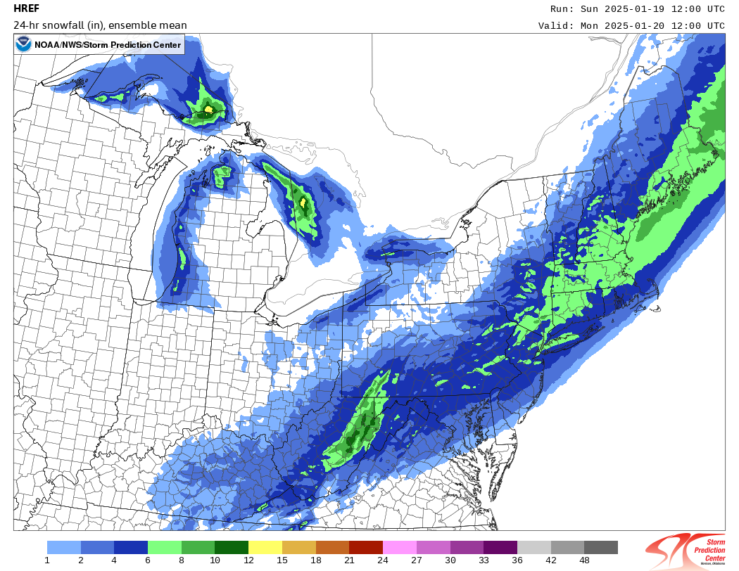
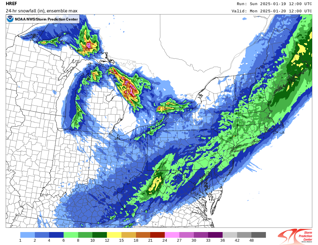
It seems to sound like he's taking that from the HREF mean that was posted.
-
Here is the latest HREF Ensembles for snow lovers out there. The one the top is the "Mean" and the one on the bottom is the "Max".
-
My call for 4-7" still holds with CT, the Central and Southern Berks with only 7-10" lollies highest elevation (Not widespread). The other will be with the classic synoptic scale east around the Boston and Northshore area where a 7-10" concentrated band will generally set up. The SouthShore 4-7" with the far SouthShore, extreme inner Cape 1-4". The rest outer Cape C-1". Generally, the forecast looks relatively on track.