

Greg
-
Posts
1,775 -
Joined
-
Last visited
Content Type
Profiles
Blogs
Forums
American Weather
Media Demo
Store
Gallery
Posts posted by Greg
-
-
3 minutes ago, MuddyWx said:
By clown range you mean anything after 0h
Anything after 60 hours on the NAM tends to get finicky.
-
3 minutes ago, Torch Tiger said:
agree with a 6-12" type deal for a decent amount of NE. I wouldn't rule out someone going over 18" though, especially with any possible wild convective banding that sets ups up in a particular zone. while 10 miles away is exhaust city. lol we've seen it with more than a couple recent storms, not impossible.
The 4-8, 8-12, and 6-10 were mostly on the table if this thing tracks classically. The 18" amount was highly unlikely with both the speed and temps on this storm. Now if, and it's a very large "If" a death band over some elevation occurred, then the possibility would increase of that happening but still in the end, an unlikely scenario.
-
Usually when you see the GEM too amped, which it does have that bias, compared to its regional one, that is a flag that the global GEM is way too amped to be real.
-
 1
1
-
-
The problem with the forecast here is truly how the SW behaves/interacts. It seems to want to hang back a little too long vs being absorbed or gelling quicker into the main offshore low. The Southeast tracks of the main ocean low are good. It keeps the heaviest precipitation in the heart of our viewing area. But if the SW hangs back too much then this thing comes farther north which is not good.
-
2 minutes ago, ineedsnow said:
light snow develops before the main show gets here... easterly flow causing it? you can see it in eastern areas on some of the GEFS members
.png.72d50594d213d71c0439014ef43b505f.png)
Yes! All the easterly wind does is help to saturate the atmosphere here. It really doesn't do much damage to the temps. This is important. You want that.
-
13 minutes ago, Sandstorm94 said:

Go out to hour 102 and hit 24 hour total. It looks better.
-
1
-
-
4 minutes ago, weathafella said:
I think that's over played actually. What are temps right above the deck up to the midlevels? I mean with that reasoning we'd never get snow in December when ssts are often even warmer than that.
Exactly! They play the marine influence card early here but with the track of the Main Surface Low offshore south of us and the Mid and upper levels fine, most of this would be snow with perhaps the exception of far Southshore cape and islands.
-
Marine influence too strong on that take from Boston but depending on the trajectory of wind the North Shore would do only slightly better in that set-up.
-
Great analysis Ray. Really get into it. Always loved that stuff.
")
-
1
-
-
Typical GEM bias being furthest north with other models further south. Interesting but not surprising knowing the traditional model biases this lag time.
-
The 4 corners region low tracks are not the best pattern to be in for snow here in the majority of New England going back 30-60 and even 90 years. As Will stated, we need get the MJO to stop hovering around the 4, 5, and 6 zones. Storm track needs to originate from more of an upper Midwest area then dive southbound with the cold highs following. Not trailing well behind or coming in too soon to just to be moving out while a storm approaches.
-
First flakes here in Wilmington.
-
1 minute ago, weatherwiz said:
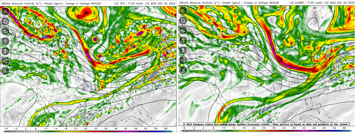
Alot of similarities, but also some striking differences between the euro and gfs at 120 hr.
Exactly what I was pointing out in another post not to mention the CMC running cold which gives some pause also.
-
1
-
-
16 minutes ago, George001 said:
Solid threat for ski areas, but temps look too marginal for the coastal plain. In December I’d like to see modeled temps in the mid to upper 20s instead of low to mid 30s before I jump on board for my area.
True, but we can still cash in when we have the upper 20's and low 30s a t this time of year. The mid 30 would be toward the Boston and SouthShore areas for sure but if the dynamics take over it would start as a mix, then a wet sleety snow for those areas.
-
2 hours ago, weathafella said:
A below normal November is sealed it would seem. Through 11/27:
BOS: -1.4
BDL: -1.9
PVD: -2.8*
ORH: -1.0*That is usually good news in a step-down process that we're in now. It's good that both Oct and Nov won't go down in histoy as being both above average leading into the winter season.
-
13 hours ago, 40/70 Benchmark said:
NE wind here isn't as big a deal as it is a bit further south in Wilmington, as the angle of the coast is sharper with latitude.....its the east and SE winds, like these first couple events, that still kill me this far north.
As Will stated, even a NE Wind with a decent high, doesn't have to be a great high in place, would be fine for even Wilmington. I've seen it myself many times even in December. But an east wind and especially a southeast wind would most definitely be a mid-level and even low-level killer for snow with any weak high or marginal airmass in place.
-
1
-
-
14 hours ago, 40/70 Benchmark said:
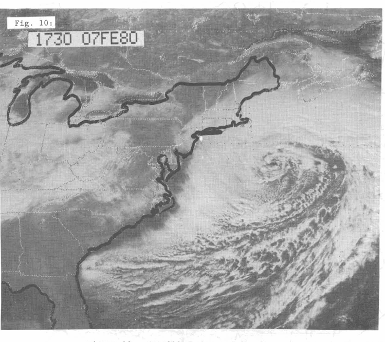
Man, I really do have a low key obsession with 12/14/1992....and this isn't me taking a passive aggressive jab at Scooter, either. I know that a lot of us get it, but I will always feel like it's perhaps the most under appreciated major east coast storm. I think even on this forum there are a lot of folks who don't really appreciate the magnitude of that system on a multitude of levels. ...I mean, you had coastal devastation that rivaled Sandy, The Perfect Storm and the Blizzard of '78....yet over 40" of snow in the Berkshires fueled by some of the most anomalous deep layer easterly fetch that will ever be observed. I think only 4/1/'97 may have matched it in that respect. Then aside from that, its romanticized to a degree in my mind as being the first major snow event as we emerged form the barren snowfall climo of my youth in the wee hours of that fateful morning.
Lets do that this month.
I don't think the coastal devestation reached quite 78 magnitude with 3-4 consecutive high tides but it was close. but Boston reported a peak tide of 9.35 ft (2.85 m), which was 1.05 ft (0.32 m) less than the record set in 1978.
-
1
-
-
On 11/14/2023 at 4:28 PM, Eskimo Joe said:
What happened during that event? Is this site the DCA of New England?
The problem for BDR is twofold actually. Number 1, it's in a valley. Many call it a shadow effect of the winds down sloping whether from an overall easterly or westerly direction. Number 2, they use a snow gauge. This has to catch snow that is already hindered by the valley shadow effect and also any wind will cause the snow to bypass the gauge a little regardless of a funnel put on top. With these relatively significant hinderances, one can pretty much see why a conservative snowfall report is somewhat the norm for that particular location.
-
-
1.8/1.9 January 2024 Peak of 3-month average.
-
2
-
-
1979-1980 Winter: Predominately a subtropical jet vs the polar jet stream year. As some on the board have illuded to a more active subtropical jet stream potential this coming winter season.
-
11 minutes ago, Sey-Mour Snow said:
Ryan posted a link 29” all time Massachusetts state 24 hour record! Already multiple 30”+ reports
Not sure that's actually a state record. Depends upon how far back he compares. 30 years, 60, 90? '78 had that in several places in less that 24 hours and that was a 30 hour storm.. April Fools Days storm of 1997 had a few of those. that was a 24-Hour storm and of course Blizzard of January 2005, 24-Hour storm. So again, not sure what Ryan is looking at.
-
Trying to see what I can make of the EC-Fast Euro on the Pivotal now. Just to see what it has.
-
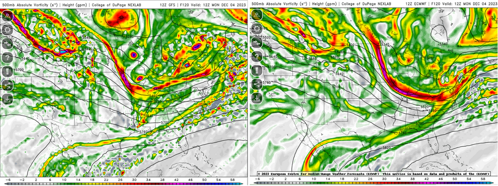
12Z GFS coming in!

-
 1
1
-
Monitoring first regional significant winter impact event. Magnitude likely tempered. At this time NE PA/SE NY and SNE primarily. Jan 7/8.
in New England
Posted
Nammy being Nammy!