

Greg
-
Posts
1,775 -
Joined
-
Last visited
Content Type
Profiles
Blogs
Forums
American Weather
Media Demo
Store
Gallery
Posts posted by Greg
-
-
The temps initially are what are going to make the snow relatively tough to accumulate readily. Seen this with the Jan 6-7 storm. All snow but struggled in the beginning with 33-34F temps never mind the 36-36F to the south in that event that mad it tougher. So, I believe that is what the Mets are trying to get at with their snow accumulation maps at the National Weather Service in Norton. Nobody is getting a settled snowfall depth of 18" out of this. That's the Color Code Range, not the prediction. Even when colder mid-levels crash in, the intensity will be key to the wet bulb. Once again Speed, Temp and Track are paramount.
-
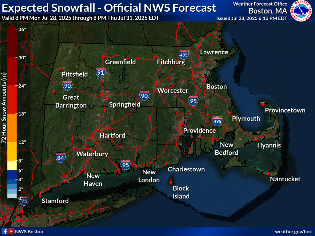
The Point Click method instead of the using the Range is probably the closest to the truth than reading (12-18") range for this particular storm. The speed of this thing, temps and its track are what are stopping this frome going higher.
-
 2
2
-
-
2 minutes ago, MuddyWx said:
Look at the ukie and put ‘em back on
Relax about crazy uncle.
-
2
-
-
2 minutes ago, WeatherWilly said:
Cape Crusher. They are overdue.
Mother nature doesn't care if one feels overdue. It can end up remaining like that for several more years. Look at why the National Weather Service of Norton, MA states about the uncertainty about the far SouthShore, Cape Cod and Islands. They state it all why.
-
 1
1
-
-
5 minutes ago, RDRY said:
Looks like NYC over Berks for this one.
And thanks you Mahomes for winning my SB box final.

I think downtown will fall a little short of double-digit snowfall unless they measure it funny and don't allow it to settle but definately North/ Northwest of that looks good.
-
2 minutes ago, ChangeofSeasonsWX said:
Does anyone have a link to that site where you can see the top analogs for a particular storm?
I know of a couple in the KU book that this somewhat resembles but not to a perfect tee though. Thay are not blockbusters but nice and decent.
-
 1
1
-
-
1 minute ago, 40/70 Benchmark said:
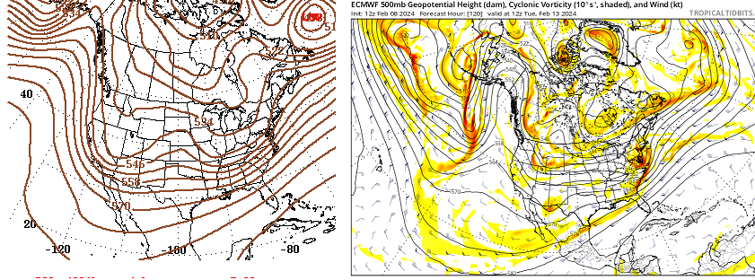
The Kuchie is absolutely more appropriate near the northern edge under H7 banding....to the south and near the coast, I agree.
Finally in agreement with you here but only on that northern periphery with the H7, the rest as I stated with the model solution, meh.....
-
1
-
-
Just now, 40/70 Benchmark said:
As skeptical as I am of the NAM, that thing isn't in range yet.
Stated the same comment to another poster just moments earlier.
-
1
-
-
4 minutes ago, Ginx snewx said:
Juxhie catches those marginal situations. These guys know what I am talking about
Your not getting that bank on it.
-
6 minutes ago, TauntonBlizzard2013 said:
Yeesh at that cutoff
It's also outside of 36 hour spoke for consitancy. Need to gett it closer in to be more relevant of a solution.
-
2
-
-
1 minute ago, NEPASnow said:
but we do live in the NE so its all relevant
No offense, I get what your saying but the Northeast is pretty broad in description,
-
1
-
-
1 minute ago, Ginx snewx said:
Look at 18Z Euro cold, even Kuchie looks good. That is a great look
Better looks don't translate to realism. Use the 10:1 instead.
-
 1
1
-
-
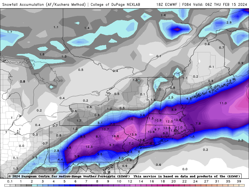
Heights will crash better than the Jan 6-7th this time, which is very good for those who have missed out on the most part of this winter, Places like Bedford, Mass Blue Hills (Milton), Boston, Northern Rhode Island, Hartford to Poughkeepsie, NY in that sort of line/corridor should do well in this one and catch up in the snowfall department.
-
1
-
-
4 minutes ago, Greg said:
Of course it's strong.
Misspoke. My bad on that. However, the rest of my statement are indeed correct.
3 minutes ago, 40/70 Benchmark said:-
1
-
-
3 minutes ago, 40/70 Benchmark said:
1.8ONI is undoubtedly strong.
Of course it's strong. Strongest I have ever seen here is 2.5 Enso in the 2016 Winter. That was extreme on the scale.
-
1
-
-
6 minutes ago, The 4 Seasons said:
you know off hand what 13-14 was?
Enso Neutral Negative. (-0.4)
-
1
-
-
To me a 0.1-0.4 is Enso neutral positive, 0.5 is Beginning weak. 0.5-1.0 is Weak to Mod, 1.0 is solid Mod, 1.0-1.5 Mod - Strong, 1.5 Beging Strong, 1.5 - 2.0 Strong to very strong, and 2.0 + or higher Super/Extreme whatever floats one's boat for a description.
-
5 minutes ago, weathafella said:
1957-58 was strong with a monster in February and then the famous March 58. The one thing about March 58 is I was staring at 10-12 inches which was slushy on the roads making sledding on hard packed street snow/ice virtually impossible.
Not sure 1.8 for an average is solid strong but moderate to strong for sure depending on the definition. But yes, Big East Coast storm for all the big I-95 cities and suburbia.
-
1
-
-
12 minutes ago, NEPASnow said:
this is only strong by sea surface temps and nothing else, this was a weak-mod el nino based on soi
I still mostly use the traditional average ONI's for the main determinant variable. However, the other variables such as the SOI and so forth can help to modify/subvert certain elements in a strong El Nino winter where one can "Buck the trend' in certain circumstances.
-
4 minutes ago, Typhoon Tip said:
Despite all peregrinations ... enough similarities to make us ponder how much the patterns really changed...
Correct! Thank you sir.

-
5 minutes ago, 40/70 Benchmark said:
2010, 1983, 1966, 1958
You are deflecting the issue....yes, weak el Nino is better....no one argued that. But you implied that it doesn't happen in strong el Nino, which is different and incorrect.
I did indicate 1983 as you saw I stated. Depends upon one's definition of a big storm. and what area coverage.
-
2 minutes ago, 40/70 Benchmark said:

Looks somewhat similar to the swath the January 6-7 storm brought us earlier.
-
2
-
-
7 minutes ago, 40/70 Benchmark said:
Most strong el Nino winters have a KU....
Not sure I agree totally with that. '78 was a week el nino, '69 was a moderate, 2005 weak, 2015 weak. Only Feb 1983 was strong.
-
Just now, Ginx snewx said:
Nope we await a KU
Not happening this winter. Take what you can get in this strong El Nino.
Following a Miller A/B hybrid type coastal potential, Feb 13th ... As yet untapped potential and a higher ceiling with this one
in New England
Posted
Take them all the way down now. Coastal graze in effect.