

Greg
-
Posts
1,775 -
Joined
-
Last visited
Content Type
Profiles
Blogs
Forums
American Weather
Media Demo
Store
Gallery
Posts posted by Greg
-
-
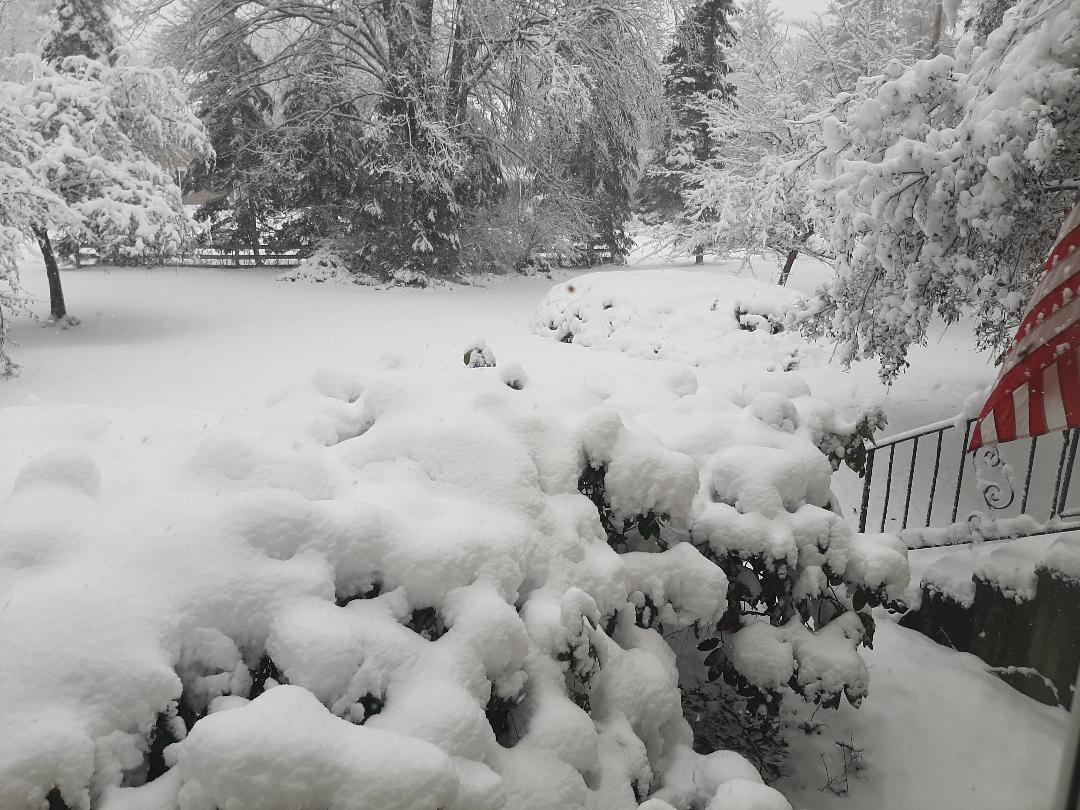
18.3 So far on the season.
-
-
2 minutes ago, TauntonBlizzard2013 said:
Yeah, probably a rough way to phrase it. I meant more down here. Im expecting very little befor sleet/sr and mostly plain rain
You'll get a slight thump of sorts that's for sure.
-
-
3 minutes ago, Damage In Tolland said:
It’s lead the way all winter . Including the screamers. No idea why it’s been bashed
I would have been rain the last storm if it was correct.
-
6 minutes ago, dendrite said:
Euro cavin' while reggie's ravin'.
Reggy Bias
-
 1
1
-
-
3 minutes ago, CoastalWx said:
I’m not picky with tracks as I don’t need to jack. I just enjoy snow. Anything from the BM to SE of ACK usually works.
Perfect track for the majority here. Excellent, I agree fully.
-
7 minutes ago, Damage In Tolland said:
Much of CT? Seems like only SE sections . Unless you’re fully buying Reggie
Both the Reggie and the GEM have a Canadian warmer bias, this is fairly well known. If those models were correct about the Jan 7th storm we had, I would have been rain through most of the storm, which of course I wasn't.
-
1
-
-
11 minutes ago, jbenedet said:
I got no horse in this race, but this trend is a PITA for BOX.
Probably why they are gun shy. At least this is why I would be...
Doesn't help either with how cold biased the GFS has been up until go time...

With the GEM "Warm Bias" and the GFS "Cold Bias", an in-between compromise would actually be in order here. Euro model will help be the decider.
-
1 minute ago, CoastalWx said:
Water has been AN locally last year and this year. Boston harbor is 44 last I checked. That’s mild. That’s not helping in marginal setups which have been constant for almost 2 years now. It doesn’t have to be balls cold, but there has been virtually no cold in the northeast preceding events and storm tracks have been huggers.
Just curious Scott. How far off sure is deemed a good track to you, just curious not trolling. Personally, my favorites are just at to slightly "inside" the Benchmark. This gives us the opportunity for two things. 1. Heaviest precip shield and 2. Close enough but at the same time far enough away from the center to have a mostly if not all snow event with the exception of the "far" South Shore and Cape and Islands.
-
3 minutes ago, The 4 Seasons said:
i was referencing pack POST the Tuesday storm.
My apologies then.
-
6 minutes ago, The 4 Seasons said:
Yeah, this past Wednesday/Thursday the mean on the EC was a huge swath of 6" across most of New England. Some of the OP runs we're pretty nice and had 8-1e.4" over E/SNE
We were looking at potentially a region wide 6-10" event or more but then things quickly fell apart and over the past couple days we've been looking at 1-3" deal (with some very good globals having nothing more than snow showers) then the possibility of 3-5" over some of SNE if things pan out well.
Expectations fell to the floor and have been recently rising a tick or two.
I think a lot of us are watching and are invested in this because 1) this winter has been complete garbage so far, so anything feels like a win and 2) we've got a solid cold shot after the storm to keep the "pack" intact and 3) a potentially significant storm on the horizon for the 20th to add to said pack.
Depends on if one even has a pack left. I had slightly over 13 inches (13.3"), without doing the 6 hour measuring method last storm and now have nothing but some very small mounts left, So not so sure of a pack than those very well far northwest of here.
-
10 minutes ago, dryslot said:
Don't really care what the GEM has, But seeing the GFS make a shift..........
It's fine that the GFS made a shift to the NW as you get closer to the event. GFS did it with the other7-8 storm also but never brought it over the Cape and Islands.
-
11 minutes ago, The 4 Seasons said:
GEM also came well NW as well.

GEM was also too far NW with its surface low track on the 7-8 storm so not sure I trust it at this moment.
-
-
Come on baby snow!

-
-
-
3 minutes ago, The 4 Seasons said:
warning snowfall in CT seems to be right near the 84 line with 6-12". S VT and S NH really got porked so far. Theyll see a few more inches but not getting near those 12-18 totals on those maps ive seen around from the NWS

GYX tend to slight over do it with there map predictions then slowly tweak them as time continues. This particular storm is one of those times.
-
1 minute ago, STILL N OF PIKE said:
more settling Where the snow was wetter longer is my guess
Absolutely! Temperature were a major key player. Even If it snowed harder in that band last night southeast of 495, If temps were 33-34F Degrees The wet snow would not have accumulated as readily as those with lesser omega northwest of 495 with temps around 30-31F degres or so. BL temps are always key to the forecast.
-
1 minute ago, 40/70 Benchmark said:
My depth is 11"...its 1" difference
That's fine. Not a problem. Just taking notes around the area for comparisons from reports.
-
 1
1
-
-
2 minutes ago, Ginx snewx said:
AWT you should push 18
If you do it every 6 hours you'll get that. If you let it settle it will be probably up a couple or so inches less. Many around here are reporting the settled amount so far with a few reporting the 6-hour method.
-
2 minutes ago, STILL N OF PIKE said:
I’m actually Impressed Wakefield accumulated 4.5”. And it was 33 there .
My Car thermo was 31 in Billerica at midnight last nite , they did much better then even Bedford and I was 32
Exactly!

-
9 minutes ago, MuddyWx said:
4.5" , 32.3F at 8:45. Some of the bigger amounts just to my NW, but not bad.. think this area gets another 5" or so when all is said and done
What a gradient here! You just about close to 5", guy right next to me in Billerica says he had 9". Must have be the texture of the snow based upon the temps last night. Some snowed at 34-35degrees while other snowed at 31-32 degrees in that band. Incredible. Hopefully a few more inches as this thing pulls away.
-
1
-


.jpg.f3ce9fc5cb24563d3c7037f96e73d238.jpg)
.jpg.5315c583e4e251ffd4ce803db5eda686.jpg)
.jpg.e68e02a0bdc37560f291100e552630be.jpg)

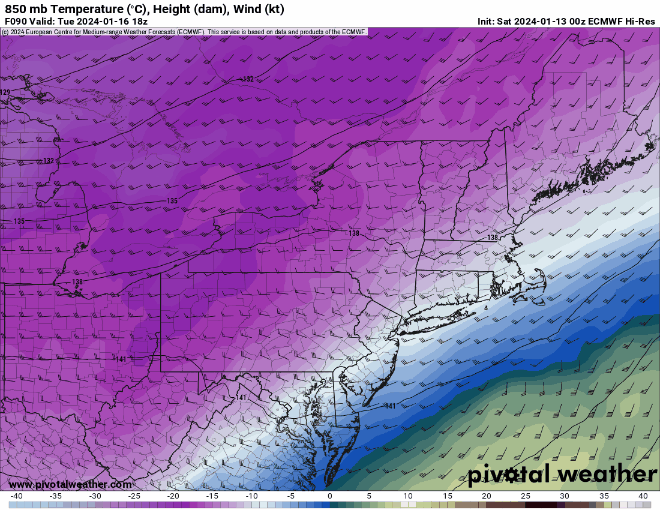
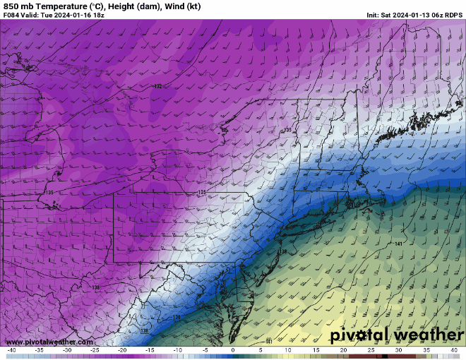
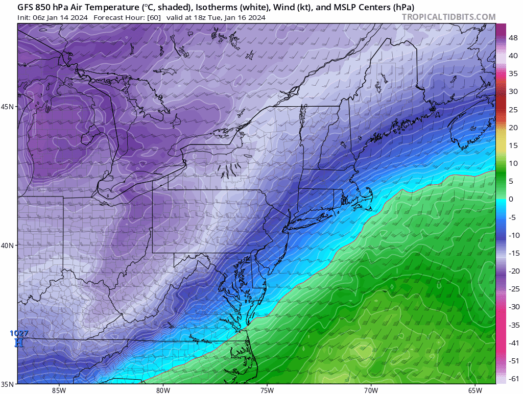
Following a Miller A/B hybrid type coastal potential, Feb 13th ... As yet untapped potential and a higher ceiling with this one
in New England
Posted
Euro would be the storm most in both Central and Southern New England would be waiting for the entire winter.