

RVASnowLover
-
Posts
983 -
Joined
-
Last visited
Content Type
Profiles
Blogs
Forums
American Weather
Media Demo
Store
Gallery
Posts posted by RVASnowLover
-
-
2 minutes ago, Sernest14 said:
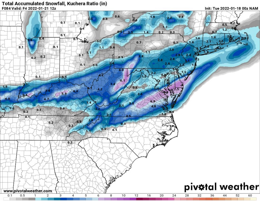
12z NAM ends up sliding a bit more south and less amped on that second wave. Still some accumulating snow for SCentral and SE VA
Thankfully it’s the NAM
-
Would be pretty impressive to get that much before the real “storm”
-
00z NAM. Not sure I’m buying the NAM. It hasn’t been great but here it is
-
Looked like a pretty big change on the 6z euro. See if it shows it again at 12z
-
 1
1
-
-
And the cold is here to stay so whatever we do get will stick around for awhile
-
Euro crushes RVA. Euro is being consistent and other models have been moving towards the Euro. We’ll see. Always have to be cautiously optimistic around here
-
1
-
-
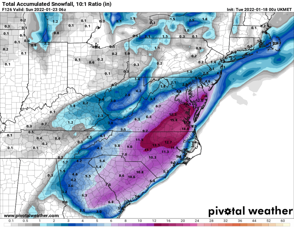
00z UK
-
3
-
-
8 minutes ago, wasnow215 said:
Saw that too! Interesting. I remember living in S Jersey before the Prez Day weekend blizzard in 2003. Sat morning had 2-3”. Sunday morning the big one started and got 20 more inches.
Would be cool to get a light event before a big one. That doesn’t happen here.
-
1
-
-
34 minutes ago, wasnow215 said:
0z NAM big hit for THURSDAY. 6” in spots.
Not sure I’m buying it but we’ll see. GFS took a big step towards the euro for Friday-Saturday. Hope the euro holds. Cautiously excited
-
1
-
-
Thursday also looks sneaky interesting
-
2
-
-
Friday night into Saturday looks very interesting. Too early for details but bares watching. The 12z euro was good
-
2
-
-
All rain now. On to the next threat which could be not far away
-
2
-
-
Sleet/freezing rain mix now
-
Sleet fest in the city
-
56 minutes ago, eaglesin2011 said:
Front end could definitely over preform, the sooner it comes in the better for us.... doubting we will get much wrap around down here but the winds could actually help that happen a bit
Agree. The sooner the precip gets here, the better
-
1
-
-
Not going to be right but 18z gfs was pretty. Happy hour gfs delivers again!!
-
51 minutes ago, eaglesin2011 said:
Next weekend looking better, cold air definitely not looking to be the problem... We will see .
Hopefully power stays on for this storm... Looks like we will escape the bigger winds before it really wraps up but still gonna be a crazy few hours from 10-am to around 3ish around here tomorrow..
Next weekend looks promising but we’ll see. Tomorrow will be dicey for several hours but we’ll warm up and things will get better
-
If the NAM is right then we’re looking at a good ice event here
-
A little early to be looking at the mesos but the 18z NAM gives us a decent amount of freezing rain. Something to watch
-
 1
1
-
-
I would think the Winter Storm Watch will be come an advisory here. Maybe I’m wrong but I don’t think Sunday will meet winter storm warning criteria.
-
I could see where we get some snow and lots of sleet before a little rain and then dry slot. CAD tends to stick around longer than models predict.
-
2
-
-
1 hour ago, Sernest14 said:
good news with the models is it's a brief transition to rain followed by dry slot so we get the initial 3-5/6" thump and brief rain.
I would actually take that
-
1
-
-
10 minutes ago, Inudaw said:
Yea this storm we are about to have is definitely a mountain favored storm. We turn toward the next threat of hope it effects areas further east for the state. Good luck western areas. ^^
The mountains should do very well. Parts of the piedmont should do well too. Just not our storm. Hopefully we cash in on the next one
-
1 minute ago, Rhino16 said:
I know it’s early, but I can’t get rid of this feeling that we do worse than last year. Future still looks good though so I’ll remain hopeful.
Overall pattern still looks good but we’ll see. So hard to get good snowstorms here. Even just a couple of small details can make the difference between rain and snow

Richmond Metro/Hampton Roads Discussion
in Mid Atlantic
Posted
Thursday’s “event” is about the cold air chasing precip and we all know how that usually goes around here