

RVASnowLover
-
Posts
983 -
Joined
-
Last visited
Content Type
Profiles
Blogs
Forums
American Weather
Media Demo
Store
Gallery
Posts posted by RVASnowLover
-
-
1 minute ago, wasnow215 said:
Like I said earlier, it’s GFS n FV3 against the rest lol. I will say I’ve never known the 3k NAM handle these types of scenarios well. Consistently too warm. Euro was kinda weak also tho. I’m riding the FV3!! Lol #weeniealert
Will be ecstatic if we can somehow squeeze how 1-2"
-
 1
1
-
-
Less than 1 inch on 18Z NAM and 3K
-
Just now, wasnow215 said:
Short term models are very warm so interesting to see how this plays out for tomorrow evening AND what 12z Euro looks like. CMC warm also. Haven’t looked at Fri much. Will do so later on.
Thermals will definitely be an issue. We'll see how it pans out.
-
1
-
-
6 minutes ago, wasnow215 said:
Cmon nothin??? Lol. GFS and FV3 drops at couple inches of snow tomorrow night. Thoughts?
Will gladly take it. Friday might be interesting too.
-
1
-
-
Sleet in Scotts Addition. Hopefully we get a nice thump at the end
-
All snow in Scotts Addition. Big flakes
-
1
-
-
4 minutes ago, ATreglown said:
The totals include sleet, which is what it is mainly showing for RIC for most of the run. That is once we get passed the next few hours of snow.
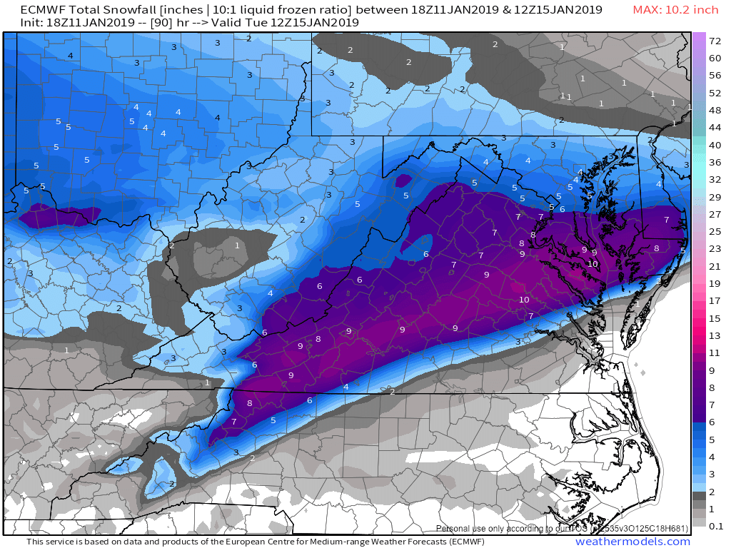
The Kuchera maps are good too
-
I like the latest HRRR. RAP isn’t bad either
-
Don’t know if it’s right but HRRR and HRDPS is colder for Richmond.
-
2 minutes ago, Freshies said:
On to the next...lol

Only a week away!!!
-
1
-
-
Crossing fingers we stay frozen longer. Ice storm is looking very real at this time. Have a hard time believing we see plain rain, south and east of Richmond yes. Hope we get a nice thumping before the changeover and maybe get some bands on the backside. Will be interesting to see what happens.
-
16 minutes ago, Freshies said:
Looks great but doesn't mean much given the aforementioned issues with mid-levels/mixing etc....

There a Kuchera for this?
-
1
-
-
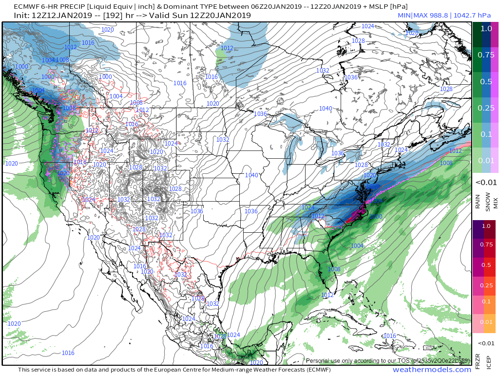
18z EURO is wetter but no idea how much of it is snow
-
1
-
-
Zach with CBS6 seems kind of bullish on snow totals but I hope he’s right
-
Don't know if it's right but GFS is A LOT better
-
RGEM is better, not great but better
-
18Z NAM looks like an ice fest.
-
2 minutes ago, Hyphnx said:
Going to be another classic nowcasting storm
Going to be interesting to see where that line is. Following short range models until then.
-
4 minutes ago, eaglesin2011 said:
def going to really depend on where the heavy bands set up. we could get lucky and not turn over and get blasted again.. .. or have a sleet/frz rain fest.. ha (gonna come in a few waves too) so maybe snow early then mix then snow again late
Agree. I think the biggest reason why we didn't see a changeover in RVA with the December storm was that we saw heavy bands come through which kept the atmosphere cold enough. Need the same again.
-
3 minutes ago, Hyphnx said:
It's been so cold, hard to believe it won't be cold enough for an all snow event. But then again, it's not even here, yet
Possible the models don't have a good handle on the cold air. Models are known for downplaying CAD. We'll see.
-
EURO goes North. Not looking good here.
-
HRDPS is intriguing. Mix line runs right through RVA. Massive drop off! Western Henrico gets anywhere between 6-8 while Eastern half gets 1-3
-
According to short range models, ice is looking more like a threat now than snow in RVA
Richmond Metro/Hampton Roads Discussion
in Mid Atlantic
Posted
Here's to hoping we get about an half inch