

Cobalt
-
Posts
4,908 -
Joined
-
Last visited
Content Type
Profiles
Blogs
Forums
American Weather
Media Demo
Store
Gallery
Posts posted by Cobalt
-
-
RGEM made a pretty substantial shift as well
.thumb.png.82ae92cb3f5aa3bae408a7ffc74ba33c.png)
-
 2
2
-
-
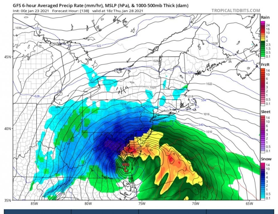
Hey friends, I've been in a coma since January 23rd, 2021, and just woke up. I'm curious, did the storm depicted on the GFS work out? It seemed like a really huge bomb! I don't think it had much consensus, but the model seemed insistent on developing a storm that bombed out over the mouth of the Potomac.
-
2
-
 5
5
-
-
14 minutes ago, WxWatcher007 said:
Congrats OCMD

What a time to be living in the ocean
-
1
-
2
-
-
One of the first cases of me understanding model bias was when I was told that the NAVGEM had an apparent "suppression" bias. This was back in 2017, but in every single instance where an image of the model has been posted, the storm is depicted more AMPED than other guidance. Is this me misremembering, or is this not a continuous occurrence?

-
6 minutes ago, WinterWxLuvr said:
^^^ this usually ends well
Still waiting for his "1996" pattern from this time one year ago to come to fruition.
-
3
-
-
8 minutes ago, nj2va said:
I miss seeing bowling ball tracks like these and confluence north of us….results in blue pixels over us!

I like seeing that initial D5 system trending towards scooting out of here faster, it allows confluence to build ahead of that intriguing system..
-
2
-
-
Obviously it's entering LR territory, but 0z GFS drops a 1045hp into the Great Plains through hr 180.. some serious cold entering the central tier of the country after that D8 storm system. Seeds of change?
-
4
-
-
The Euro weeklies are.. not exactly the most enticing. Somewhat serviceable for the first week of January I suppose, but coupled with the incredibly persistent -PNA, it looks like the waning neg NAO results in the SE ridge really flexing its muscles after that point. Looks like a less favorable Atlantic has been the trend for the past few days in the LR.
-
1
-
-
8 minutes ago, jaydreb said:
Yep, today’s EPS also transitions into a pretty good looking pattern.

Nice to see that pretty stout 50/50 signal too..
-
27 minutes ago, jaydreb said:
12z GEFS starts dumping cold air into the eastern US after the New Year. Stout -NAO all the way through the run.
Pretty amazing anomaly for a 16-day mean.

Pretty decent agreement among the Canadian, GFS, and Euro ensembles for the timeframe into very early Jan. Much like with the fabled D10-15 blocking pattern presented on the models in early Jan of last year, it seems like we'll have to wait a while for those effects to show up in the medium range, only this time we're looking at that pattern shift 2 weeks earlier.
-
-
RGEM holds steady

-
4
-
 1
1
-
-
1 hour ago, SomeguyfromTakomaPark said:
You guys ever wonder what would be happening if we had global cooling instead of global warming? Imagine if the waste product of industrial civilization happened to make things cooler instead of warmer. Imagine if summer was getting shorter and the ice caps were growing. I betcha we’d take it more seriously.
For a time.. that'd be cool, and we'd be chilling. Eventually though, we'd have to face the cold hard facts.
-
1
-
-
41 minutes ago, psuhoffman said:
I just realized since moving up here March is the month most likely to produce a warning level snowfall. Probably why I get annoyed when people start talking about spring in February.
I recall you saying that you hadn't gone a winter without a warning level snowfall since 01-02 and that you were overdue..

-
5 minutes ago, WxWatcher007 said:
Watch list or…
Wait, I’m retired.
Carry on, Deb. Carry on.
Reaper watch > winter storm watch
-
2
-
-
1 hour ago, MJO812 said:
Gfs changes every run
18z agrees
-
35 minutes ago, Guest RIC Airport said:
BWI reached freezing before midnight 11/4. The CLI is based on standard time, not daylight savings time.
Meanwhile, RIC should reach it by sunrise as it currently 35 with plenty of time left.
If anyone had BWI for 11/4, they would've.. guest correctly
-
1
-
-
The Braves winning the World Series for the first time since October 1995 gives us a clear top analog for this upcoming winter #itshappening
-
3
-
1
-
2
-
-
2 hours ago, psuhoffman said:
We can probably handle the rare case of someone acting out with mute/remove. But if we want to add an additional layer of security we could create a forum email list and send the code that way to avoid imposters.
I think anyone who has made significant contributions to our region should be invited. Just my 2 cents.
It's all fun and games until DT comes in and gets in an all-out brawl with Ji
-
2
-
3
-
-
5 minutes ago, WxUSAF said:
Persistent cloud cover is probably going to sink my chances of a freeze tonight.
The mesos have been pretty bearish about sub-freezing cold at the surface tonight, but suggest tomorrow night might have a better chance
-
5 minutes ago, midatlanticweather said:
Would be cool. Moderating it could be a huge challenge!
Yeah, I'm not too familiar, how would moderation/verification go for those calls? It would be a shame if someone joined pretending to be someone else, only to end up being deliberately disruptful.
-
1
-
-
2 hours ago, Kmlwx said:
Generalizing here - but that would all but eliminate having the older folks on the forum join a video call. Discord is weighted so heavily towards the younger gaming crowd. Again...I am generalizing and I know some older people who do use it and game. Discord would be best for the 30 and under crowd. At this point with COVID and such - you'd be hard pressed to find people who have never heard of Zoom. Even the park police volunteers I work with outside of work (most of them are 60+) have been able to join Zoom calls and be totally fine.
This is entirely true, Zoom does seem like the best option.
-
1
-
-
Discord is always an option, as it has built in video calls, but it might be a bit tougher to set up/facilitate.
-
4
-
-
1 hour ago, NorthArlington101 said:
It's hardly going to be a perfect test but the EPS/Euro is almost totally out on the storm existing while the GFS/GEFS is still toying around with the idea -- not necessarily for snow, just for it's literal existence. Curious to see which suite takes the early lead in accuracy.
the ICON is insistent that we get some cold rain from the #snoreaster
.png.9630c528e7e12c0d3db0e98ee0724bb5.png)
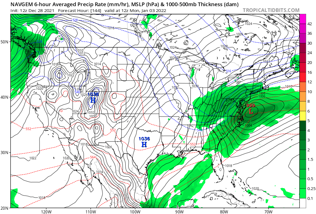


January 3 CAPE Storm
in Mid Atlantic
Posted