

Cobalt
-
Posts
4,908 -
Joined
-
Last visited
Content Type
Profiles
Blogs
Forums
American Weather
Media Demo
Store
Gallery
Posts posted by Cobalt
-
-
5 minutes ago, Warm Nose said:
Can we get them all to phase?
A septuple phased system might be so amped that it loops around the globe a full time.. would still clip NW Virginia though
-
 1
1
-
 6
6
-
-
-
Hmmm...
-
3
-
 1
1
-
-
1 minute ago, NorthArlington101 said:
if this is truly a non-event and the EURO is showing 20" 5 days out we need to write a protest letter to the EU, or whoever is in charge of it.
The differences in h5 are already incredibly apparent at hr 84. Check out GFS vs Euro for that timeframe. Those differences amplify very quickly afterwards
-
1
-
-
Just now, WinterWxLuvr said:
WB snow maps are ridiculously bad
While that is inflated due to Kuchera, precip is pretty hefty too. If this falls in the low 20s with 850s well below freezing as depicted? Could definitely see ratios better than 10:1.

-
1
-
2
-
-
2.6" as of 5:45pm, right before sleet took over. All in all the storm definitely met expectations with several hours of SN/SN+. Feels like it's been ages since we've had a cold temps Colorado powder type event, and this definitely delivered.
Oh, and that makes 12.9" of snow so far on the winter. Snowiest through Jan 16th since.. 09/10

-
4
-
-
1.0” as of 4pm. This marks the earliest that this location has had three separate 1” snow events since the 2013/2014 winter. Impressive stretch around these parts.
.-
5
-
1
-
-
0.6" as of 3:30. Nothing like watching cold powder fall at home with some
badfootball alongside it.-
1
-
-
-
6 years to the day...
-
1
-
-
Just now, Amped said:
Impressive snowstorm in the SE. Another closed low 500 low moving across the gulf coast
Looks pretty enticing. NAO goes from - to + during this timeframe, so there's decent HA storm signal. Would probably also help offset how far east the trough is. Ensembles should be fun.
-
2
-
-
1 hour ago, CAPE said:
Check out the 12z CMC for the upcoming period. Imagine this place if it played out like that lol.
Euro looking to do something similar near hr 150.
-
14 hours ago, psuhoffman said:
Just have to lol. This is where the actual snowstorm ended up.

I think I mentioned 12/16/20 as having stark similarities, but this really reminded me of the 2016 President's Day storm

I'll do my best to find sfc/upper level maps from that storm, but it was a similar situation. On Feb 14th it was 25/13 at DCA! We hardly can even manage that high temp for a low nowadays. It didn't matter though, as the track and screaming SE winds eroded what little cold remained, all the way up to upstate NY. Temps spiked to 53 at DCA on the 16th. As for that random small snow max south of DCA, I don't fully remember. One thing I've noticed about these WAA dependent events is that they tend to max on an unsuspecting area, depending on the onset of precip. Whatever max this produces will likely be oriented to the west and be wayyy different, but it's an interesting anecdote, these events tend to be full of surprises.
-
2 hours ago, jaydreb said:
Still a small signal around 1/22-23.

GEFS is holding onto that signal as well. Still showing up a bit on the OP runs, like with what the Canadian tried to do at hr 180. Pretty suppressive look up top, but as we learned with this recent system, that can easily change.
-
1
-
-
18z GFS tries to do something akin to the D7 storm the Canadian has
One door closes, another opens..
-
2
-
1
-
-
52 minutes ago, psuhoffman said:
It did...but that storm the low tracked up into the delmarva and the warm layer blasted some sleet and a dry slot into south central PA to places like Harrisburg. That was significantly further NW than thinking...but I've seen that before, especially with a bad upper level track in that case. But here the upper and mid level track is through VA just south of DC. The surface track is up just west of the bay. And the NAM is mixing with sleet and freezing rain all the way to Lake Erie. That seems a bit off. Ive never seen THAT!
The 2016 President's day storm might be a better analog in this situation. That was a truly arctic airmass going into it.. but the cold air was scoured away incredibly quickly with a rather intrusive LP track. Single digits to 50s in just a day.
-
1
-
-
Just now, yoda said:
Arctic cold and not much
It did make a baby step towards what the Canadian is trying to hint at for our D7 storm. Had a weak LP system bringing light snow to costal SC. Kinda reminiscent for what this weekend's system showed at the same timeframe, but man that is some brutal cold pressing down during the same timeframe. Negatives for the far western burbs.
-
1 minute ago, Sernest14 said:
curious on how well the HRRR generally does?
Posted this for the Jan 3rd storm. This typically seems to be the bias, let's see how it holds up once the storm enters the 48hr HRRR run range.
On 1/2/2022 at 2:32 PM, Cobalt said:At this time during storms where we're on the SE fringe, we look to the HRRR to have a colder and more SE solution compared to general guidance (and it ends up being wrong)
-
Wraparound precip from the 12z Euro

-
1
-
 2
2
-
5
-
-
8 minutes ago, LP08 said:
GFS sure is trying to for next weekend.
Our cold air source is wrecked by the lakes low, but it definitely was a step to something more interesting (edit: more like a leap). Hoping ensembles pick up on it a bit.
-

850s seem to be subfreezing for the entirety of this panel. Definitely something to watch once the mesos get into range.
-
3
-
1
-
-
4 minutes ago, Ji said:
the 12z gfs ticked something somewhere
Yeah.. it ticked people off considering that it is just now catching on to the warm nose
-
1
-
-
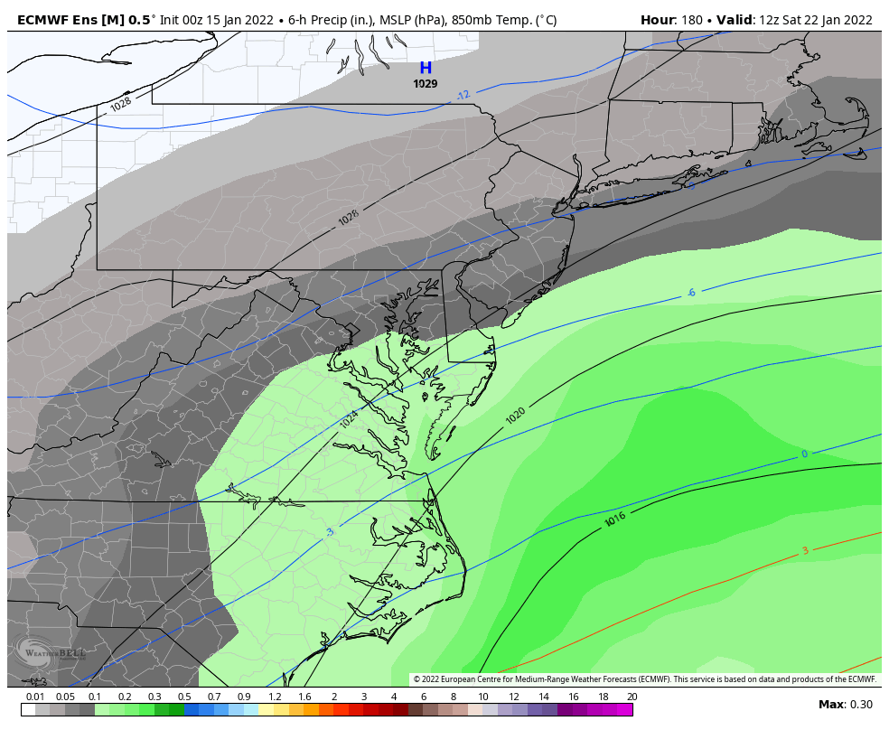
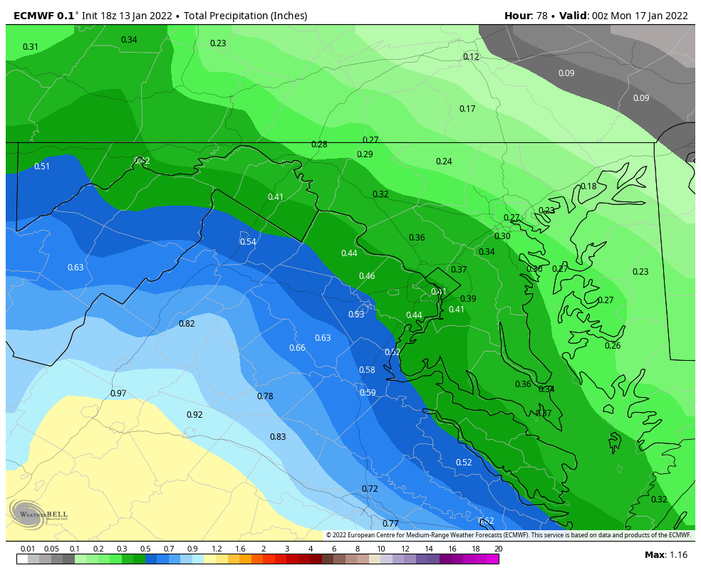
Here's precip through 0z Monday

And 850s at that timeframe. Still holding on
.thumb.png.3b1e4451b2ab927df3190323a5c90812.png)
-
1
-
-
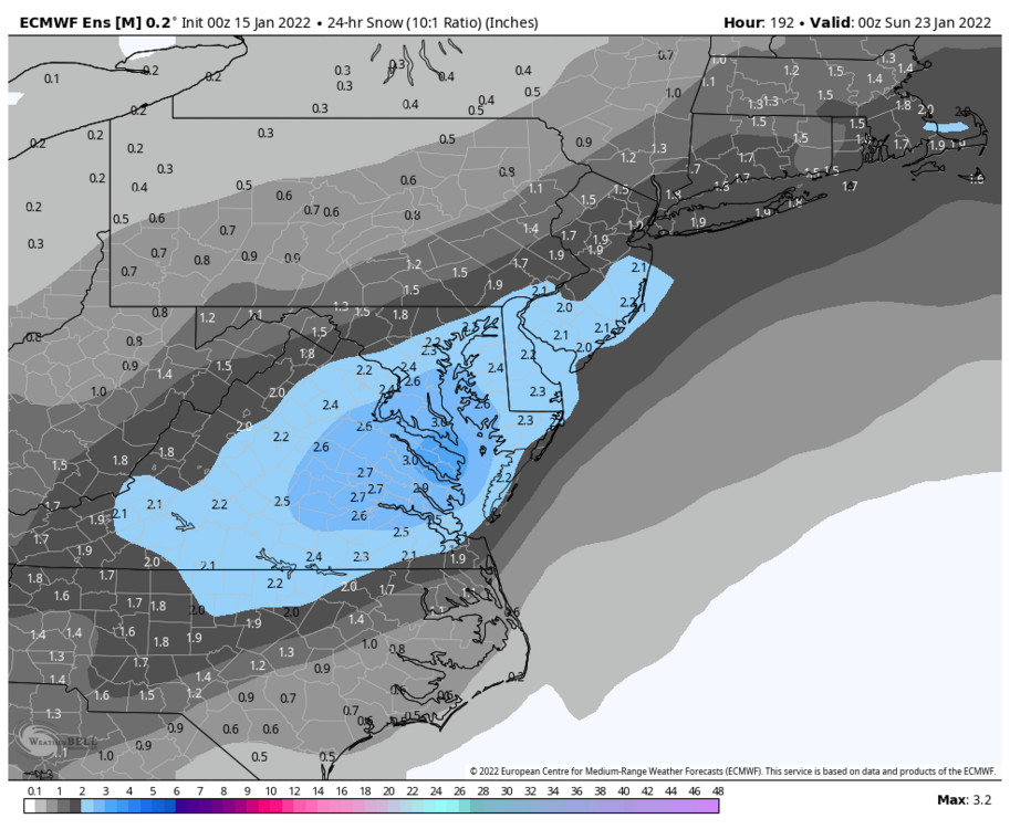
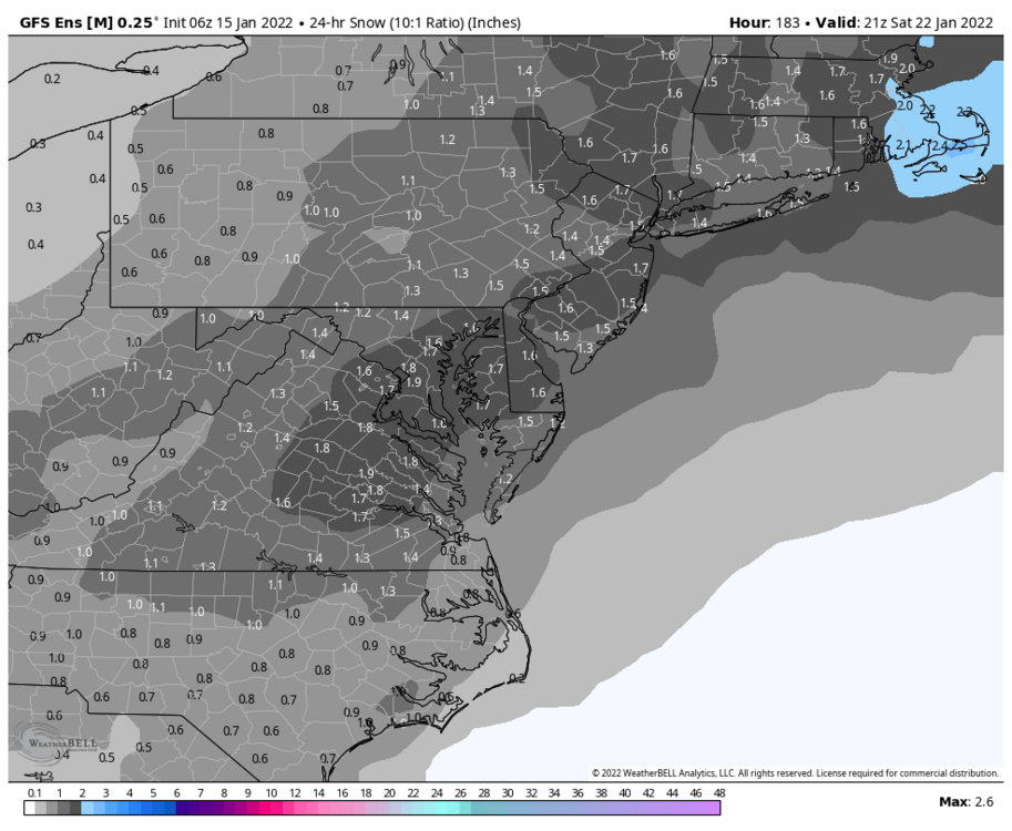
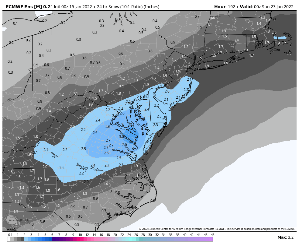
Will the 22F DCA saga finally come to an end with this?


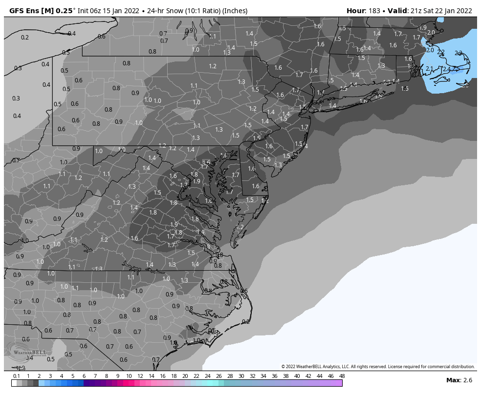


.png.e67c1db7be32274257f833c4b7e6151a.png)
January Medium/Long Range Discussion
in Mid Atlantic
Posted
Just a tiny difference..