

Cobalt
-
Posts
4,866 -
Joined
-
Last visited
Content Type
Profiles
Blogs
Forums
American Weather
Media Demo
Store
Gallery
Posts posted by Cobalt
-
-
1 minute ago, CntrTim85 said:
I'm in Corolla til' next week. Chesapeake should get an inch or so. Will sure look nice for them! Chesapeake has almost gotten more snow than you over recent years! Good luck! LOL
lol i'm sure they have. Thank you for making snow measuring a competitive sport!
-
5 minutes ago, CntrTim85 said:
I said this earlier and got burned at the stake. Dry air will destroy the back edge of this thing. It already happened in Tuscaloosa, AL tonight. Combine that with temps and possible rain/sleet and the bust potential is HIGH.
How's the event holding up for you in Chesapeake?
-
 1
1
-
-
Winter storms bring out some of the most interesting characters on this board.
-
 5
5
-
-
1 minute ago, Natester said:
I'm from the midwest but I've been watching this thread. I have a question, when was DC's last big snowstorm? Was it 2018?
Jan 12-14 2019 produced 10" at DCA, it was long duration storm, albeit with light rates for most of the event.
-
1 minute ago, Ji said:
last time it was this warm before a major snowstorm...was March 2001.....
March 2014 for sure, that was upper 60s in mid march sun. Cooled down pretty handily with dews crashing shortly after sunset...
-
1 minute ago, nj2va said:
Yes.
Long range HRRR is not reliable, don’t bother with it.
Might be the weenie in me, but at this time during storms where we're on the SE fringe, we look to the HRRR to have a colder and more SE solution compared to general guidance. I definitely remember this for our sleet bomb last February.
-
 1
1
-
-
4 minutes ago, mappy said:
I’m only looking at precip totals, 00z had me at .7, now it’s .4
in fact it’s drier area wide, eastern shore was over 2 qpf, now it’s closer to 1
Part of this could be due to the fact that 0z still had some rain from overnight impacting totals
Ninja'd
-
1
-
-
15 minutes ago, Amped said:
NWS actually gives us a good chance for an over-performer.
Add it to the list:
1/30/2010
1/6/2015
1/12/2019
Pending: 1/3/2022
3/17/2014 as well. The environment leading into the event is pretty similar to this, as temps peaked in the 60s the day before with precip onset after nightfall. Fairly different setup overall but that definitely surprised some.
-
17 minutes ago, stormtracker said:
6z NAM continues the northwest bump
3k NAM agrees
-
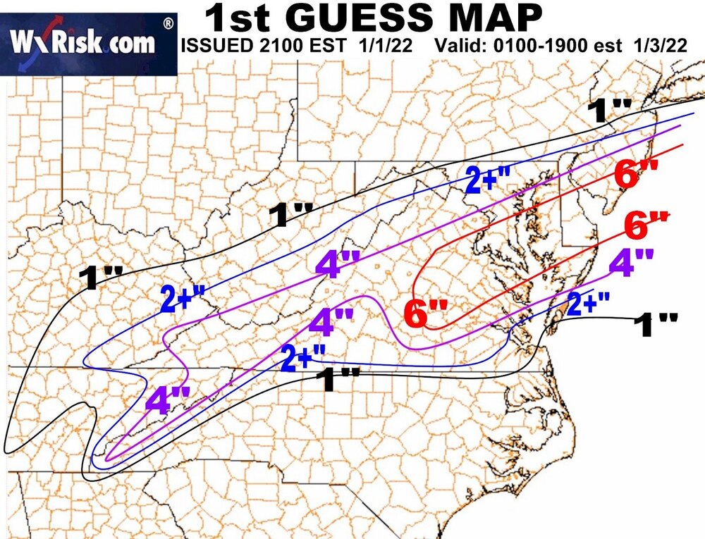
DT's first guess map. Bit of a banterish observation, but this seems to resemble some of the medium-sized events from Feb 1996, no? I recall seeing a few that bullseyed SE of DC in this fashion.
-
2
-
-
Here's a quick visual comparing the 0z Euro to the 0z EPS. It's hard to tell since it's overlayed on top of the EPS, but the big L represents the operational. A fair bit of lps NW of the mean, and of course there's the cluster well offshore, but that scenario seems to be dwindling with every model cycle.

-
5
-
-
6 minutes ago, nj2va said:
On the Meteocentre maps only (not the ‘prettier’ maps yet), but UKMET took a big jump NW as well.

Probably the most significant shift out of any non-meso compared to its 12z counterpart. Still not as amped as others, but takes the 1" snow line into DC.
-
4
-
-
Just now, Bob Chill said:
You lookin for me?

-
3
-
 4
4
-
-
RGEM made a pretty substantial shift as well
.thumb.png.82ae92cb3f5aa3bae408a7ffc74ba33c.png)
-
2
-
-
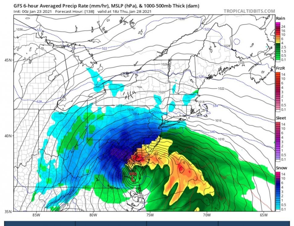
Hey friends, I've been in a coma since January 23rd, 2021, and just woke up. I'm curious, did the storm depicted on the GFS work out? It seemed like a really huge bomb! I don't think it had much consensus, but the model seemed insistent on developing a storm that bombed out over the mouth of the Potomac.
-
2
-
5
-
-
14 minutes ago, WxWatcher007 said:
Congrats OCMD

What a time to be living in the ocean
-
1
-
2
-
-
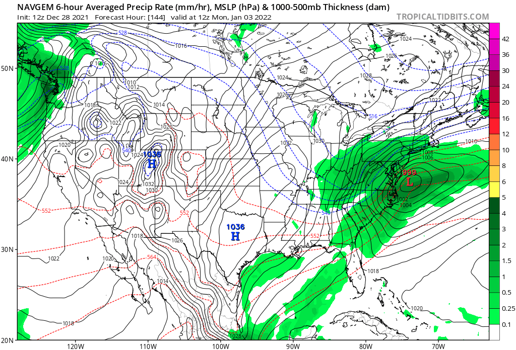
One of the first cases of me understanding model bias was when I was told that the NAVGEM had an apparent "suppression" bias. This was back in 2017, but in every single instance where an image of the model has been posted, the storm is depicted more AMPED than other guidance. Is this me misremembering, or is this not a continuous occurrence?

-
6 minutes ago, WinterWxLuvr said:
^^^ this usually ends well
Still waiting for his "1996" pattern from this time one year ago to come to fruition.
-
3
-
-
8 minutes ago, nj2va said:
I miss seeing bowling ball tracks like these and confluence north of us….results in blue pixels over us!

I like seeing that initial D5 system trending towards scooting out of here faster, it allows confluence to build ahead of that intriguing system..
-
2
-
-
Obviously it's entering LR territory, but 0z GFS drops a 1045hp into the Great Plains through hr 180.. some serious cold entering the central tier of the country after that D8 storm system. Seeds of change?
-
4
-
-
The Euro weeklies are.. not exactly the most enticing. Somewhat serviceable for the first week of January I suppose, but coupled with the incredibly persistent -PNA, it looks like the waning neg NAO results in the SE ridge really flexing its muscles after that point. Looks like a less favorable Atlantic has been the trend for the past few days in the LR.
-
1
-
-
8 minutes ago, jaydreb said:
Yep, today’s EPS also transitions into a pretty good looking pattern.

Nice to see that pretty stout 50/50 signal too..
-
27 minutes ago, jaydreb said:
12z GEFS starts dumping cold air into the eastern US after the New Year. Stout -NAO all the way through the run.
Pretty amazing anomaly for a 16-day mean.

Pretty decent agreement among the Canadian, GFS, and Euro ensembles for the timeframe into very early Jan. Much like with the fabled D10-15 blocking pattern presented on the models in early Jan of last year, it seems like we'll have to wait a while for those effects to show up in the medium range, only this time we're looking at that pattern shift 2 weeks earlier.
-
.png.9630c528e7e12c0d3db0e98ee0724bb5.png)


January 3, 2022 CAPE Storm Obs/Nowcast
in Mid Atlantic
Posted
2.8” in McLean as of 9am. Would not be surprised to be exceeding 4” within the hour, heavy snow with yellows on the doorstep. 1.3” from 8 to 9.
.